http-equiv="content-type">
Forum Hadriani - Voorburg
Forum
Hadriani – Voorburg. A capital for the Cananefates
Establishment
of town and granting of city charter
The town in Voorburg probably started
life in the mid-first century AD as a small population centre beside
Corbulo’s
Canal. After the formation of the civitates (administrative regions) in
the
province of Germania Inferior between AD 82 and 90, the town was
designated a
civitas capital. Somewhere between AD 120 and 151 it was granted a city
charter, which meant it could call itself a ‘municipium’. From that
point on,
its new name was Municipium Aelium Cananefat(i)um (abbreviated to MAC).
It is
not clear whether the name Forum Hadriani predates MAC. Indeed it is
quite
possible that both names were used simultaneously. We do however know
that the
name Forum Hadriani was used for longer. It appears on a Late-Roman
road map,
and was eventually handed down to us via a Medieval copy of this map.
Building
phases in the town
A
settlement beside the canal
There are several phases to the Roman
town in Voorburg, best known by the name Forum Hadriani. First, a small
population centre was built on the site of an indigenous settlement,
quite
possibly because of its position beside Corbulo’s Canal. Traces of this
early
phase are very rare. In fact the history of the town can only really be
properly traced from the end of the first century.
The
town grows
 During
the reign of Domitianus (c. AD
80-90) the core of the town probably lay at the site of the later bath
house. A
building made completely or partially of stone probably stood here,
indicating
that it had a special function. The orientation of buildings and
streets would
later change. The small town stood on a main road that had recently
been laid,
transecting the traces of the old indigenous settlement. The early town
straddled both sides of the road. Three adjacent rectangular houses
from this
phase have been found. The plots were an average of around six metres
wide and
fifteen metres deep, with their short side to the street. Behind the
houses was
a yard containing a well. The inhabitants also buried their waste
behind their
homes, as evidenced by a number of waste pits. The exact size of the
early town
is not known, as only sporadic traces from this period have been found.
However, finds from the site suggest that it grew in importance during
this
period. Since the town lay beside Corbulo’s Canal, it might also have
housed a
small base for the Roman fleet. If there was a harbour, however, it
cannot have
lasted long. Recent research has shown that Corbulo’s Canal had silted
up by AD
200, making navigation impossible.
During
the reign of Domitianus (c. AD
80-90) the core of the town probably lay at the site of the later bath
house. A
building made completely or partially of stone probably stood here,
indicating
that it had a special function. The orientation of buildings and
streets would
later change. The small town stood on a main road that had recently
been laid,
transecting the traces of the old indigenous settlement. The early town
straddled both sides of the road. Three adjacent rectangular houses
from this
phase have been found. The plots were an average of around six metres
wide and
fifteen metres deep, with their short side to the street. Behind the
houses was
a yard containing a well. The inhabitants also buried their waste
behind their
homes, as evidenced by a number of waste pits. The exact size of the
early town
is not known, as only sporadic traces from this period have been found.
However, finds from the site suggest that it grew in importance during
this
period. Since the town lay beside Corbulo’s Canal, it might also have
housed a
small base for the Roman fleet. If there was a harbour, however, it
cannot have
lasted long. Recent research has shown that Corbulo’s Canal had silted
up by AD
200, making navigation impossible.
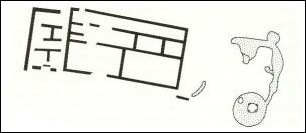
Blocks
of houses in a large town
 The
town did not really begin to
flourish until after it had been granted a city charter (somewhere
between AD
120 and 151). It had a classic rectangular grid pattern, the hallmark
of a true
Roman town. For a long time, archaeologists thought they had found a
military
site. The town consisted of blocks of houses (insulae) and a number of
public
buildings. One of the blocks has been almost completely excavated. Long
narrow
houses stood on two sides. The houses were adjacent to each other, with
their
short side facing the street. An arcade
running in front of all the houses gave the appearance of a single
façade. Behind the houses were yards surrounded by fencing,
which met at the
back. At the end of the yards, against the fencing, many waste pits
have been
found. Recent excavations have also revealed wells in the back yards.
Most of
them used an old wine barrel as facing, but in one of the wells the
walls were
made of parts of a recycled dugout canoe. In some streets remains of a
wooden
road surface that must have been laid around the mid-second century
have been
found.
The
town did not really begin to
flourish until after it had been granted a city charter (somewhere
between AD
120 and 151). It had a classic rectangular grid pattern, the hallmark
of a true
Roman town. For a long time, archaeologists thought they had found a
military
site. The town consisted of blocks of houses (insulae) and a number of
public
buildings. One of the blocks has been almost completely excavated. Long
narrow
houses stood on two sides. The houses were adjacent to each other, with
their
short side facing the street. An arcade
running in front of all the houses gave the appearance of a single
façade. Behind the houses were yards surrounded by fencing,
which met at the
back. At the end of the yards, against the fencing, many waste pits
have been
found. Recent excavations have also revealed wells in the back yards.
Most of
them used an old wine barrel as facing, but in one of the wells the
walls were
made of parts of a recycled dugout canoe. In some streets remains of a
wooden
road surface that must have been laid around the mid-second century
have been
found.
In
the second half of the second century the town was surrounded by a
stone wall.
About a century later, around AD 270, the town appears to have been
almost
entirely abandoned.
|
Phases
at Forum Hadriani – Voorburg
|
|
To c. AD 47
|
Indigenous settlement
|
|
c. AD 47
|
Corbulo’s Canal dug. Construction
of a
(small?) population centre beside the canal at the site of the later
town
|
|
c. AD 90
|
Voorburg becomes the official
civitas
capital of the Cananefates
|
|
from c. AD 121/122
|
Final layout with rectangular grid
pattern and blocks of housing. At initiative of emperor Hadrian?
|
|
between AD 121 and 151
|
City charter granted: new name
Municipium Aelium Cananefatium. Also known as Forum Hadriani
|
|
AD 138-161
|
Major construction work
|
|
c. AD 275
|
Town abandoned
|
Public
buildings
We currently have too little
information for an extensive discussion of the public buildings in
Forum Hadriani.
We do however know about the bath house and the town wall.
The
bath house
The bath house at Forum Hadriani in
Voorburg was excavated in the early 19th century by the world’s first
professor
of archaeology, C.J.C. Reuvens. He meticulously recorded his finds and
even
measured the height of the features, which was very unusual for that
time.
Since he had so little material for comparison, it was difficult for
him to
interpret the features. But his precise records and beautiful drawings
have
allowed them to be interpreted more recently. The bath house was
probably built
between AD 120 and 150. The remains consist mainly of stone
foundations,
fragments of wall paintings and other finds. Little remained of the
standing
walls. It appears to have been a bath house of the ‘row type’, like the
bath
house in Heerlen. On leaving the changing room one would first enter
the
frigidarium, the cold plunge pool. Beyond that lay the tepidarium,
where the
temperature was more pleasant. The final pool in the row was the
caldarium, the
hot water bath. The water in this room was heated by a furnace behind
the
caldarium. The bathing rooms were along one side of an inner courtyard.
On the
other side there was probably a water tower. The walls of this
structure have
heavier foundations, and buttresses were even added at a later stage to
support
the great weight of the water. There was also a large public toilet in
the
building, which was probably also used by people entering from outside
the bath
house.
The
town wall
In the second half of the second
century a stone wall was built around the town. Prior to this the town
had been
surrounded by an embankment and a moat. A second moat was dug next to
the first
when the stone wall was built. There were also stone gateways in the
wall, one
small and one large example of which have been excavated to date. The
style of
the gates supports the dating in the second half of the second century.
From
the end of the second century, gateways protruded from the outside of
the wall.
However, the two gates in Voorburg barely protrude, if at all,
suggesting that
they were constructed before the end of the second century.
Homes
Houses
and yards
Throughout the Roman period, the main
material used for building in the Netherlands was wood. Walls consisted
of
wattle covered with daub. Buildings in town were often rectangular,
with their
short side facing the street. The same type of houses are also found in
smaller
rural towns. Traces found in Forum Hadriani show a row of rectangular wooden
houses and their internal layout. There were wells in the yards
behind the
houses. Along the front of the houses ran an arcade forming a single
roof.
Stone
buildings
The use of stone for building really
only took off in the second century. Natural stone had to be imported
from far
away, as there was no stone suitable for building in the Netherlands.
Wooden
houses were only gradually replaced by stone structures, so wooden and
stone
buildings would have stood alongside each other.
Houses
of the rich
There will most probably have been
larger houses in Forum Hadriani. Unfortunately, we do not know what
they looked
like, as the traces found give us too little information.
Museum
For more information about Forum Hadriani, visit Museum Swaensteyn in Voorburg or Museon in The Hague.
References
Bazelmans, J.G.A. en D.H. de Jager,
2006, Forum Hadriani. De Verloren stadVan Romeinse stad tot monument.
Utrecht
Buijtendorp, T., 1982, Een Romeinse stad bij
Voorburg-Arentsburg. Een interpretatie. Westerheem 31, 142-163
Buijtendorp, T., 1984, Nieuw onderzoek naar Forum Hadriani.
Westerheem 33, 1984, p. 116-124
Buijtendorp, T., 1987, Periodisering van Romeins Voorburg. Westerheem 37, 1988, 107-117
MUST &
B. Colenbrander (red), 2005, Limes Atlas. Rotterdam.
Waasdorp, J.A. 2003, IIII M. P. naar M. A. C. Romeinse
mijlpalen en wegen. (Haagse oudheidkundige publicaties nr. 8) Den Haag.