See this text in ![]()
The oldest Roman architectural remains, such as a two-roomed wooden structure beneath the public baths, are dated to the mid-1st c. B.C., that is, still during the period of the freien regnum Noricum. The first stone buildings seem already to have existed in the early- to mid-Augustan period. Here, a trading vicus consequently grew up at the site of an important intersection of the Drau valley with a route leading to the gold deposits in the Hohe Tauern. What is today East Tyrol was once the homeland of the Laianci tribes, while the neighbouring Saevates (cf. Sabiona/Säben in the Pustertal) equally fell under the administration of the city. Celtic hilltop settlements around Aguntum are known on many of the hills (for example Lavant, Breitegg near Nussdorf), but have hardly been investigated. The Claudian city rights are attested by Pliny the Elder, and its status as a municipium is supported by inscriptions, including those orginating from a funerary association (cultores Genii municipii Agunti). A military camp seems never to have existed in this region.
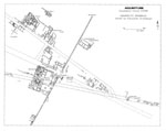
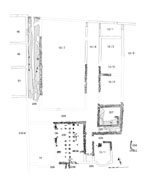
Only a very small section of the built-up area, buried under meters of gravel associated with the Debant rivulet, has been brought to light to date. The settlement developed at the forked intersection of the east-west running route in the Drau valley and a branch leading north over the Großglockner (Hochtor) towards Iuvavum (the Tauernstraße). The Drau valley route would have functioned within the city as the decumanus maximus. This road led through an impressive gate in the city walls; inside the city on its north side it was bordered with a 3.5 m. wide portico with columns spaced at a distance of ca. 4 m. In the north the Tauern route formed the next decumanus, while traces of two additional streets, running roughly parallel, can be recognised. Only very little is known regarding the north-south connections between these through-routes and their parallel streets; there seem to have been no cardines running through the town.
The overall size of the city is still uncertain. To the east of the city wall, in the wedge created between the long-distance routes, suburban residential buildings and workshops have been excavated, while the extent of the town to the west, north and south is not known. The demonstrable length of the built-up district along the Drau valley road extends more than 450 m., and the known length of the city wall in a north-south direction measures approximately 320 m.
 |
 |
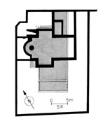
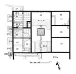
The oldest known bathing establishment was installed into a pre-existing apsidal hall building dating to the Augustan period, the bath complex perhaps already constructed during the early years of the reign of Tiberius according to numismatic finds, long before the settlement attained civic rights. The apsidal hall (inner diameter 13 x 6 m.) was furnished with surface heating and received at least one annex with a bathing pool. After a fire in the late 1st c. A.D., a bath complex of the Row Type was established, with the following series of surface-heated rooms: Apodyterium (changing room, R 113) – Frigidarium (cold baths, R 105), Tepidarium (lukewarm heated room, R 104) – Caldarium (warm baths, R 100). The praefurnium was located outside the caldarium to the east. Both the caldarium and the frigidarium possessed annexes at the north and south with bathing pools. In the course of the 2nd and 3rd centuries, additional heated rooms were added at the north, and an entrance corridor or portico was added along the street in front of the apodyterium. At the south, a room with its own separate heating system might have been a sudatorium (sweat room, R 106). The baths were equipped with an extensive drainage system.
 |
 |
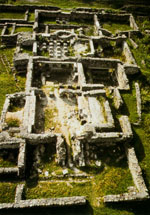 |
Within the insula to the south of the public baths, a so-called ‘ostentatious building’ has been discovered, with a hall with an interior area of 300 m² and a row of additional rooms; so far more than 1,000 m² of constructed area is known. The interior furnishings with marble floors, polychrome wall paintings and the remains of a bronze statue of an emperor are suggestive of a public building in the vicinity of the as-yet unidentified Forum.
 The so-called city wall remains completely
puzzling. It is a matter of a double wall (total width 2.54 m.) running in
a straight line, with connecting cross-bridges every 14.8 m., and with earth
fill in the empty spaces in between the wall faces. A gate flanked by towers
was located on the decumanus maximus; at first this only had a simple single passage, later a double one. Additional
side passages served in part other streets passing through, in part also optical
symmetry. The southern end of the city wall was cleanly finished off, while
the northern end has disappeared under mud and gravel. The gateway has windows
on the east side, but all of the important buildings known so far lie to the
west of the city wall. According to archaeological finds in the filling material
between the wall faces, a construction date at the earliest in the Hadrianic
period is possible; currently, however, a construction date in the 3rd c. is favoured. In addition to fortification needs (Marcomanni wars of ca. 170,
attack by the Alemanni in the 3rd c.), pure ostentation, or protection against flooding and landslides have also
been considered as reasons for the wall’s erection.
The so-called city wall remains completely
puzzling. It is a matter of a double wall (total width 2.54 m.) running in
a straight line, with connecting cross-bridges every 14.8 m., and with earth
fill in the empty spaces in between the wall faces. A gate flanked by towers
was located on the decumanus maximus; at first this only had a simple single passage, later a double one. Additional
side passages served in part other streets passing through, in part also optical
symmetry. The southern end of the city wall was cleanly finished off, while
the northern end has disappeared under mud and gravel. The gateway has windows
on the east side, but all of the important buildings known so far lie to the
west of the city wall. According to archaeological finds in the filling material
between the wall faces, a construction date at the earliest in the Hadrianic
period is possible; currently, however, a construction date in the 3rd c. is favoured. In addition to fortification needs (Marcomanni wars of ca. 170,
attack by the Alemanni in the 3rd c.), pure ostentation, or protection against flooding and landslides have also
been considered as reasons for the wall’s erection.
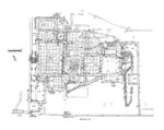
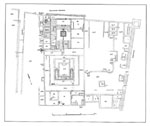
The so-called Atrium House of Aguntum represents one of the most important residential complexes from the northern provinces overall. It lies directly to the west of the city wall, to the south of the decumanus maximus; its area encompasses ca. 3,000 m² of built space, and additional court- and garden areas to the west and south, the dimensions of which have not yet been completely recorded.
The main tract (ca. 61 x 30.5 m.) was oriented north-south, and possessed three large individual units: at the north, during building phase 1 (mid- to second-half of the 1st c. A.D.), a central rectangular atrium with impluvium was flanked at each side by three living rooms, each having an inner area of 50-70 m². In the 2nd c. A.D., an entrance room was separated off from the atrium and the western row of rooms was rebuilt for a different purpose: a heated passage now led past four markedly smaller rooms, the northernmost one now fitted with a hypocaust heating system.
In the central section of the house, a roughly square garden peristyle covered the entire width of the house; this had a central water basin (15.5 x 17 m.) with watertight floor and walls of marble slabs. An additional row of rooms containing a triclinium constituted the southern termination.
Connected to the east, and with approximately the same area as the imposing residential tract, additional heated rooms lay to the north, one of which had an apsis and which has until now been identified as a private bath. New investigations which have revealed absolutely no installations for water make this interpretation doubtful. The excavations in this area have not yet been completed.
 |
 |
 |
 Of the remaining houses of the early and
high imperial period, only House 1 has been closely studied and published.
This house is situated at an intersection or fork of the northernmost known decumanus, and reveals a correspondingly distorted ground plan. Two heated rooms, each
with in inner area of ca. 5 x 6 m. and with three parallel chambers existing
on the street side, formed the core of the house. After a seemingly open passage
area of ca. 2 m., an additional row of rooms and a large courtyard area followed
to the west, apparently having a commercial function. Based on archaeological
finds, the house was used from the beginning of the 1st c. until the late 3rd c. A.D., and underwent numerous construction phases.
Of the remaining houses of the early and
high imperial period, only House 1 has been closely studied and published.
This house is situated at an intersection or fork of the northernmost known decumanus, and reveals a correspondingly distorted ground plan. Two heated rooms, each
with in inner area of ca. 5 x 6 m. and with three parallel chambers existing
on the street side, formed the core of the house. After a seemingly open passage
area of ca. 2 m., an additional row of rooms and a large courtyard area followed
to the west, apparently having a commercial function. Based on archaeological
finds, the house was used from the beginning of the 1st c. until the late 3rd c. A.D., and underwent numerous construction phases.
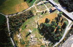
The excavations in Aguntum may be visited during the summer months as an open-air museum; a new excavation museum has been constructed above sections of the Atrium House.
W. Alzinger, Das Municipium Claudium Aguntum. Vom keltischen Oppidum zum frühchristlichen Bischofssitz, ANRW II 6 (1977) 380–413.
W. Alzinger, Aguntum und Lavant. Führer durch die römerzeitlichen Ruinen Osttirols (1995).
V. Gassner, Zur Funktion und Datierung der Stadtmauer von Aguntum, Römisches Österreich 13/14, 1985–1986, 77–100.
N. Heger, Die Skulpturen der Stadtgebiete von Aguntum und Brigantium, CSIR Österreich III 4 (1987).
S. Karwiese, Aguntum – das Ende einer Stadt im Spiegel der Münzfunde. Eine numismatisch-archäologisch-historische Untersuchung, Beiträge zur römerzeitlichen Bodenforschung in Österreich 2 (1974).
W. Klimesch, Haus I. Funde aus einem Aguntiner Wohngebäude, Grabungskampagnen 1991 und 1992 (1995).
M. Tschurtschenthaler, Die Forschungen des Instituts für Klassische Archäologie in Aguntum im Jahr 2002, in: ArchaeoTirol Kleine Schriften 4, hrsg. v. J. Zeisler und G. Tomedi (2002) 211–215.
M. Tschurtschenthaler, Municipium Claudium Aguntum. Das Atriumhaus im Licht der aktuellen Forschungen, in: L. Dal Ri – S. di Stefano (Hrsg.), Archeologia Romana in alto Adige – Studi e contributi. Archäologie der Römerzeit in Südtirol – Beiträge und Forschungen (2002) 1070–1089.
M. Tschurtschenthaler, Municipium Claudium Aguntum: Die Ausgrabungen der Jahre 1999 bis 2001, in: Akten des 9. Österreichischen Archäologentages am Institut für Klassische Archäologie der Paris-Lodron-Universität Salzburg vom 6. bis 8. Dezember 2001, hrsg. v. B. Asamer – W. Wohlmayr (2003) 231–236.
M. Tschurtschenthaler, Übernahme und Transformation mediterraner Wohnkultur im Alpenraum, in: Synergia, Festschrift für Friedrich Krinzinger. Hrsg. V. B. Brandt – V. Gassner – S. Ladstätter, II (2005) 467–473.
E. Walde, Begleitheft für den Besuch der Ausgrabung von Aguntum (1998).
E. Walde, Aguntum, in: M. Šašel Kos – P. Scherrer (Hrsg.), The Autonomous Towns in Noricum and Pannonia – Die autonomen Städte in Noricum und Pannonien: Noricum, Situla 40 (2002) 149–163.
E. Walde – D. Feil, Funde aus Aguntum (1995).