Siehe diesen Text auf xxx
Virunum, as the successor of the city settled on the Magdalensberg in the mid-1st c. B.C. by Roman traders, was founded under Emperor Claudius (41-54 A.D.) as a planned municipium in the plain of Zollfeld on the Glan, which afforded much more favourable communication routes. Therefore, from the city’s foundation, ca. 3,000 Roman or strongly romanised inhabitants were immediately available. From the organisation of the province of Noricum until the Marcomanni wars of ca. 170 A.D., the city served as the seat of the praesidial procurator of Noricum, and was therefore at the same time the provincial capital. The imperial fiscal procurator, who was responsible for tax collection for the province and who assisted the new governor and legionary commander who resided in Lauriacum, also had his official seat in Virunum.
There are only scarce traces of an Augustan-period trading settlement in the region of the later city. An important trading settlement of the early imperial period, however, appears to have developed only about 2 km. further to the north, at St. Michael am Zollfeld. The fact that a large temple precinct was set up here in the Hadrianic period, however, indicates that this settlement was not abandoned in favour of the new city.
|
|
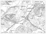
| Virunum surroundings | Construction exten |
A military camp which has been identified on the basis of aerial photography at the eastern extension of Virunum might have already existed prior to the foundation of the city.
No Celtic settlement of any importance has been identified to date either in the region of the city on the Magdalensberg or in the region of the Zollfeld settlement. The location of the central settlement and the hilltop royal seat of the Norici, whose tribal lands were located in the territory of Virunum, are not known.
The city was developed in monumental fashion under Trajan and Hadrian (Forum and main temple, amphitheatre), suffered during the Marcomanni wars, and attained its largest and most impressive architectural embellishment during the reigns of the Severan emperors.
An area which is interpreted as a military camp is only known to date from aerial photography and surface survey. It lay in relatively close proximity to a building identified as the palace (praetorium) of the procurator Augusti provinciae Norici, that is, the provincial governor, and to larger structures which have not yet been more closely investigated in the hilly land at the eastern perimeter of the city. At present it is assumed that on the one hand the camp accommodated soldiers on the staff of the governor and a small engagement troop, while on the other hand troops who protected the transport of gold en route to the Imperial treasuries in Rome were garrisoned here. Based on the military inscriptions which have been found thus far in the surroundings of Virunum, it can be assumed that no regular unit was stationed here; instead, only particularly reliable soldiers from the various auxiliary units distributed throughout Noricum were assigned to duty here. According to patterns of growth in the landscape, an additional settlement area, thickly settled and regularly organised, extended between the camp and the praetorium; dependents of the soldiers, or tradesmen who enjoyed business relations with the gubernatorial authorities or the military, may possibly have lived here.
 |
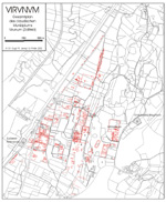
| Military camp and praetorium |
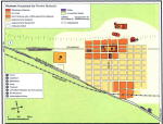
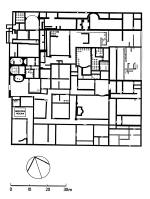
The city plan of Virunum, on the Zollfeld near Maria Saal, can still be partially identified today on the basis of streets, field pathways, and land parcel borders, since the area of the city was never built over by larger structures after the end of the Roman period. Almost 1 km. to the north of the densely built up city core, which was equipped with a regular street grid and which covered an area of ca. 1 km², the long-distance routes which ran through here divided; one branch ran past the city tangentially to the west. The other branch led axially to the area sacra with its main temple next to the Forum and served as the decumanus maximus of the inner urban land survey system. This street divided the insulae to the north and south of the Forum region into two narrow strips. The cardo maximus ran between the temple precinct and the Forum in an east-west direction. The residential quarters lay for the most part between the Forum and the tangential street; the majority of the city blocks of roughly square form measured between 66 to 72 or almost 100 m. to a side, while a few insulae were notably smaller or laid out in rectangular fashion. The width of the gravelled roads was between 10 and 15 m. The precise interpretation of the surveying system and the inner-urban city grid is frustrated by the fact that the plans stemming from the pre-World War I excavations can be fitted into the current land survey plan only very approximately.
 |
 |
| City plan Virunum | Virunum grid system |
To the east of the Forum only one more insula row was located; after this the land rises and becomes hilly. At the edge of the ascent were located the only stage theatre in Noricum, and an amphitheatre; further up the slope lay a building complex interpreted as the palace of the governor but which has not been more closely investigated, and a military camp recently discovered through aerial photography and land survey.
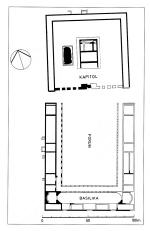
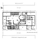
The Forum (ca. 120 x 95.5 m.), partially excavated already in 1909-1911 and later filled in again, lay almost at the eastern margin of the city on the axis of the decumanus maximus which ran into the city from the north. The open courtyard was paved with stone slabs. The northern side, oriented towards the area sacra, was open, while on the remaining three sides a single-aisled portico surrounded the court. Behind these porticoes on the long sides offices of civic officials and shops were situated; on the west side, according to an inscription found here, there was apparently also a sanctuary dedicated to the Genius Noricorum. The south side was the location of a single-aisled basilica (58 x 12 m.) with an apse at each of its ends; the basilica formed the entrance to another apsidal room lying behind it. At its southern façade, the basilica had three monumental entrances, between which four laterally-disposed narrow rooms were laid out. Of these rooms, the second (seen from the west) was fitted with a hypocaust heating system throughout, suggesting a function as a tabularium or archive room.
 |
 |
 |
| Forum and temple | Forum with basilic | Forum and temple |
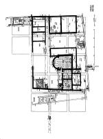
Excavations in around 1910 revealed the central area sacra in Virunum, enframed by a U-form colonnade with cryptoporticus and extending over an entire insula (almost 90 m. long per side) on an artificially elevated piazza (1.8 m. height) adjoining the Forum to the north. The erection of the sanctuary in its known form ought to have taken place during the reign of Emperor Hadrian (117-138), based on the remains of architectural decoration. In the centre of this plaza stood a podium temple (35.6 x 24.6 m.) with a deep pronaos formed only by columns, and with a tripartite cella (proportions 1:2:1), which is indentified in the scholarship as a Capitolium. Almost directly to the west of this main temple an additional platform measuring 22.35 x 11.1 m. was uncovered; this was for a long time interpreted as a basis for a monument, but more recently it has been proposed that this formed the substructure of yet another temple.
A further unidentified temple on the northern boundary of the city of Virunum is only comprehensible from its substructure. Even further out towards the edge of the city, in the angle at the junction of the main road running past Virunum (the tangential route) and that of the road branching off from it and leading to the so-called Capitolium and Forum, the decumanus maximus, is located an unenclosed area, recognised only from aerial photographs, extending roughly over 130 - 150 m., and with a single structure located almost in its centre. Based on the similarity of this area with one known from Cambodunum in Raetia, it has been interpreted as an ara Noricum, an assembly area for the Norican provincial government complete with Imperial altar.
At the northern perimeter of the city, a four-roomed structure (17.7 x 11.6 m.) was excavated in 1913; based on the inventory of cultic objects found here, and a building inscription dating to 189 found in the area, this complex has been identified as a cult building for Jupiter Dolichenus. Various inscriptions – including a bronze tablet found in a pit in the west of the city and naming the members of a society of Mithras – and the fragments of a marble cult image with reliefs of the legend of Mithras, indicate that there were at least two Mithraea in Virunum in the late 2nd century. Furthermore, the building inscription from a temple of Isis has also been discovered.
 |
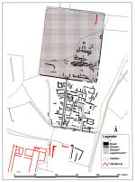
| Dolichenum |
About 2.7 km. north of the Forum of Virunum, at the junction of the north-south road leading into the city and an east-west connecting road leading into the Glan valley, a temple precinct built at the vicus which grew up at this intersection has been investigated since 2001. On top of the remains of earlier buildings, which are not necessarily to be identified as having a cultic function, an irregularly formed, enclosed plaza, paved with paving stones and with a total area of 60 x 52 m., was laid out, most probably in the Hadrianic period. The surrounding colonnades in the east and west were fitted with two large exedrae located opposite each other, to which were adjoined taberna-form chambers open to the outside. The two-roomed podium temple (16.8 x 9.6 m.) oriented to the south, possessed an axially-located altar with socle dimensions of 3.6 x 2.7 m. Fragments of two votive altars, a votive column, and a bronze statue of the type of Hercules bibax (drunken Hercules) indicate that this temple was dedicated to Hercules.
The theatre building with a stage, excavated between 1926-1930, is the only one of its kind known to date in Noricum; it had a semi-circular area for spectators, with a radius of 35 m. The structure was completed at the top by a covered walkway with a roof supported by piers. The stage was 32.5 wide and 5.8 deep. Behind it lay a 4.5 m. wide colonnade with seven chambers and a two-storey elaborate façade decorated with niches and facing the city. Lower down the hill slope lay two colonnades staggered above one other. A supplementary structure built on to the theatre building at the north is interpreted as a temple.
 |
| Theatre ground plan |
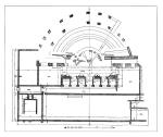
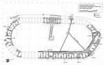
In spite of its form which resembles a circus, the amphitheatre in Virunum, described as such many times in inscriptions, was erected at the earliest after 131 (date of the felling of the trees), and renovated under Emperor Commodus. A building inscription, which is probably datable to 183, mentions plastered walls, main entrance, and gateways. During the co-reign of Septimius Severus and his sons (building inscription from the period 198-211), the amphitheatre was further embellished with wall paintings (picturae). Additional restorations and renovations after fires were frequently necessary in the 3rd century (building inscription from 15th May 237). Under Emperor Constantine I (309-337), shortly after 315 A.D., the operation of gladiatorial games seems to have come to an end here: the altars and reliefs dedicated by the gladiators and patrons of the games to their goddess Nemesis were deliberately buried, along with a number of contemporary coins, and the sanctuary of the goddess at the eastern apex of the amphitheatre was closed.
 |
 |
| Excavation plan | Aerial photograph |
The construction of the amphitheatre in general took the form of a double oval of 108.10 x 46.5 m. maximum dimensions, with ca. 4.5 – 4.7 m. distance between the walls which were constructed of quarry stone and lime mortar. The tribunes for the spectators must have been built of wood and were erected on top of these ground walls. Seven rows of seats probably provided a total seating capacity for ca. 3,000 people.
During the excavation of the amphitheatre, in addition to diverse drainage channels, a wooden piping system and a spring source running underneath the building came to light; these contributed to the drinking water supply for the city.
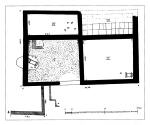
Already at the beginning of the 20th century the Insulae I (so-called Bathing district) and IV, neighbouring the Forum at the west, were excavated. Two additional city blocks at the far west of the city were uncovered a few years ago. As far as can be established from these excavations, surface survey, and additional observations, the residential insulae possessed closed exterior walls, although questions regarding the standardised interior division and the size of the land parcels have not been sufficiently clarified.
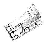
Insula I, which was square and measured ca. 72 m. per side, preserves evidence in its north-west of a bath of the Ring Type with courtyards and heated additional rooms covering a total surface area of 1060m²; this bath has given the name ‘Bathing district’ to the entire building complex. It appears to have constituted the private bathing facility of the residential unit, whose large peristyle court is identifiable adjacent to the east. The dating that has until now been proposed for the bath, in the 4th century, is certainly too late. Further details concerning the ground plan of this house, which underwent four building phases from the 1st to the 4th centuries, cannot be stated with certainty.
 |
| Bathing district |
Another residential unit with a bathing tract appears to have taken up the south-eastern third of this insula, if indeed these did not constitute numerous separate houses. In the south-west of the insula lay an additional unit with an apsidal hall (13. x 8 m.), whose southern vestibule was decorated with an almost perfectly intact mosaic floor covering 30 m² depicting Dionysiac motifs. Two additional rooms, one of which was heated, were attached at the south, while a long corridor lay to the east. The adjacent courtyard tract at the east with its numerous rooms can only have belonged to the same residential unit. Widely dispersed here were found the almost life-size marble statues belonging to an ensemble of divinities (Aphrodite, Fortuna/Noreia, Mars, the Dioscouri, Satyr, Dionysos), broken up in the 4th century. According to the current interpretation, this area is to be identified as a schola, the meeting premises of an organisation; it could, however, also have been a large private house with peristyle courtyard and impressive reception hall.
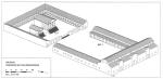
The adjacent insula IV (ca. 70 x 37 m.) to the north probably only contained one residential unit with a peristyle court; two apsidal heated rooms lay on its east side. These functioned, at least in building period 2, as a bath. In the eastern third of the insula were situated impressive living and reception rooms; a row of rooms at the south probably contained shops.
 |
| Insula IV |
At the western perimeter of Virunum, at Cardo V-West, parts of two insulae have been investigated since 1992. Houses were built here at the earliest after the mid-2nd century, but the insula was only fully developed during the Severan period. As far as can be determined in spite of the heavy damage caused by modern agricultural development, the so-called ‘North-east Building Complex’ (44 x 29 m.) consisted of two tracts of land separated by a courtyard. To the north lay a number of commercial rooms with simple loam floors; to the south, an ensemble (260 m²) consisting of three rooms, each with its own heating, one with an apse, and corridors. The ‘South-east Building Complex’ is even more poorly preserved, although preserves yet again evidence of a heated group of rooms containing an apsidal room. The reports published to date have identified these heated room ensembles, with their polychrome wall paintings and relatively large apsidal main room, as a residential tract; a utilisation as a bathing complex has also been considered.
 |
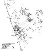
| North-east Building Complex |
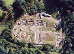
The amphitheatre has been conserved since 2003 and made accessible to visitors. The remaining finds are only recognisable as features in the landscape, built over or filled in. In the neighbouring vicinity of Virunum, many stone monuments are visible, built into the walls of churches (in particular in Maria Saal and St. Donat) and castles. On the Zollfeld itself stands the so-called Prunnerkreuz, a small chapel erected from ancient stone monuments by Johann Dominikus Prunner, a scholar of antiquity, in 1692.
The finds, amongst them the sculpture group from the so-called Bathing district and the bronze Mithras tablets, are displayed in the Landesmuseum Kärnten in Klagenfurt.
Carinthia Romana und die Römische Welt. Festschrift für Gernot Piccottini zum 60. Geburtstag, hrsg. von F.W. Leitner, Aus Forschung und Kunst 34 (2001).
M. Doneus – Ch. Gugl – R. Jernej, Ein neu entdecktes römisches Militärlager in Virunum (Noricum). Erste Ergebnisse der Luftbildauswertung, Archäolog. Korrespondenzblatt 33, 2003, 393–402.
M. Doneus – Ch. Gugl – R. Jernej, Luftbildarchäologie in Virunum: Ein römisches Militärlager östlich der Stadt, Forum Archaeologiae 29/XII/2003 (http://farch.net).
M. Doneus – Ch. Gugl – R. Jernej, Neue Ergebnisse zur Siedlungstopographie von Virunum: ein neu entdecktes römisches Militärlager, in: Die norisch-pannonischen Städte und das römische Heer im Lichte der neuesten archäologischen Forschungen. II: Internationale Konferenz über norisch-pannonische Städte, Budapest-Aquincum 11.–14. September 2002, Aquincum Nostrum II.3 (2005) 217–231.
Ch. Gugl – R. Jernej (Hrsg.), Virunum. Das Römische Amphitheater. Die Grabungen 1998–2001 (2004).
O. Harl, Der Stadtplan von Virunum, Jahrbuch Zentralmuseum Mainz 36, 1989, 521–598.
O. Harl, Zum gallorömischen Umgangstempel in Österreich, Archäolog. Korrespondenzblatt 15, 1985, 217–234.
E.M. Luschin, Das Stadtzentrum von Virunum, Jahreshefte Österr. Archäolog. Inst. 72, 2003, 149–175.
G. Piccottini, Virunum (mit Beiträgen von H. Dolenz, F. Glaser und R. Jernej), in: M. Šašel Kos – P. Scherrer (Hrsg.), The Autonomous Towns in Noricum and Pannonia – Die autonomen Städte in Noricum und Pannonien: Noricum, Situla 40 (2002) 103–134.
G. Piccottini, Mithrastempel in Virunum, Aus Forschung und Kunst 28, 1994
C. Praschniker – H. Kenner, Der Bäderbezirk von Virunum (1947).
H. Vetters, Virunum, ANRW II 6 (1977) 302–354.
Wege nach Virunum, Archäologieland Kärnten 1 (1999).
Excavation Reports and individual studies regularly appear in: Carinthia; Rudolphinum. Jahrbuch des Landesmuseums Kärnten; Fundberichte aus Österreich