Виж този текст на български език ![]()
Political structures before the Romans
Cities from the pre-Roman period
Roman Colonies
Basilica
Theatres
Thermae
 The first
mention of Thracia and the Thracians can be found in Homer. Later on, the Father
of History Herodotus writes (V, 64) about the Thracians that they are one of
the most numerous of peoples, after the Indian and the Scythian. The Thracians
were a combination of many tribes with close language and culture. They were
of Indo-European origin and populated the eastern part of the Balkans from
3000 BC on. A significant number of scientific studies have been written on
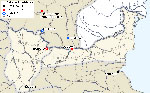
their origin and territorial scope. The lands between the Lower Danube and
Moesians, Krobyzoi and Gaetae. The latter lived on the territory of present-day
north-east Bulgaria and the northern part of Dobrudja mountain in Romania.
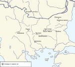
The earliest data on Gaetae political union date back to 4th c. BC. Helis is marked as the centre of this union.
The first
mention of Thracia and the Thracians can be found in Homer. Later on, the Father
of History Herodotus writes (V, 64) about the Thracians that they are one of
the most numerous of peoples, after the Indian and the Scythian. The Thracians
were a combination of many tribes with close language and culture. They were
of Indo-European origin and populated the eastern part of the Balkans from
3000 BC on. A significant number of scientific studies have been written on
their origin and territorial scope. The lands between the Lower Danube and
Moesians, Krobyzoi and Gaetae. The latter lived on the territory of present-day
north-east Bulgaria and the northern part of Dobrudja mountain in Romania.
The earliest data on Gaetae political union date back to 4th c. BC. Helis is marked as the centre of this union. 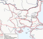 Some scholars assume that
this Gaetae political centre, which is mentioned repeatedly in historical sources,
was located near the present-day village of Sboryanovo (northeast Bulgaria). The territory which was under the political control of
the Gaetae changed borders during the Hellenistic period. Generally, this territory
bordered to the east
with the Black Sea, to the west – with the rivers Yantra and Rossitsa, to the
south it reached Haemus and to the north it was crossed by the Lower Danube.
The western border was quite mobile, and especially in the decades before the
Roman conquest it even reached the Iskar River valley. Sources provide little
information about the political structures on the territory of present-day
northwest Bulgaria. This zone, especially during the period 3rd – 2nd c. BC was home to active migration processes and its dynamics influenced the
study of the region. The Triballi settled here in 4th c. BC, to be pushed east by the Autariati and the Scordisci. In the next two
centuries the region was also settled by Celtic tribes, but the migration processes
probably continued. Thus, despite the large number of Thracian treasures from
the northwest Thracian territories, not one tribal or city centre is known
from there to this date.
Some scholars assume that
this Gaetae political centre, which is mentioned repeatedly in historical sources,
was located near the present-day village of Sboryanovo (northeast Bulgaria). The territory which was under the political control of
the Gaetae changed borders during the Hellenistic period. Generally, this territory
bordered to the east
with the Black Sea, to the west – with the rivers Yantra and Rossitsa, to the
south it reached Haemus and to the north it was crossed by the Lower Danube.
The western border was quite mobile, and especially in the decades before the
Roman conquest it even reached the Iskar River valley. Sources provide little
information about the political structures on the territory of present-day
northwest Bulgaria. This zone, especially during the period 3rd – 2nd c. BC was home to active migration processes and its dynamics influenced the
study of the region. The Triballi settled here in 4th c. BC, to be pushed east by the Autariati and the Scordisci. In the next two
centuries the region was also settled by Celtic tribes, but the migration processes
probably continued. Thus, despite the large number of Thracian treasures from
the northwest Thracian territories, not one tribal or city centre is known
from there to this date. 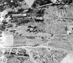
 The state system in Thracia was established by the Odrysai who established a
powerful ruling dynasty and founded a state – the Odrysian kingdom - at the beginning of 5th c. BC. The head of the state was a king (or a great basileus)
and he held the political, military and religious powers, or he was a one-man
ruler in the kingdom. The throne was hereditary. The king ruled together with
a family council (Thracians – aristocrats, direct relatives) and close ones
(other dynasties and strategists). The whole political, legal and financial
power was concentrated in the hands of the king and his council. Characteristic
of the Thracians, especially in the period of the maturing of their state system,
was that their kings – rulers resided in different places. With time, however,
the tribal centres acquired elements of city culture. They were constructed
on naturally protected terrains and most often, on a terrain which was dominant
in relation to the surroundings. The lands between the Lower Danube and Haemus and especially those in the eastern
part of the region were periodically and partially included in the Odrysian
kingdom, since the Gaetae were a very strong tribal formation. In 1982 a unique
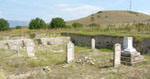
in terms of its relief decoration with caryatids royal tomb was found near
the village of Sveshtari, next to the village of Sboryanovo, Isperih municipality . It has been declared a monument under the protection
of UNESCO. The tomb is an important indicator for the localization of a large tribal centre in the region . The latter has already been found at the archaeological
site "Water station" and is systematically sudied.
The state system in Thracia was established by the Odrysai who established a
powerful ruling dynasty and founded a state – the Odrysian kingdom - at the beginning of 5th c. BC. The head of the state was a king (or a great basileus)
and he held the political, military and religious powers, or he was a one-man
ruler in the kingdom. The throne was hereditary. The king ruled together with
a family council (Thracians – aristocrats, direct relatives) and close ones
(other dynasties and strategists). The whole political, legal and financial
power was concentrated in the hands of the king and his council. Characteristic
of the Thracians, especially in the period of the maturing of their state system,
was that their kings – rulers resided in different places. With time, however,
the tribal centres acquired elements of city culture. They were constructed
on naturally protected terrains and most often, on a terrain which was dominant
in relation to the surroundings. The lands between the Lower Danube and Haemus and especially those in the eastern
part of the region were periodically and partially included in the Odrysian
kingdom, since the Gaetae were a very strong tribal formation. In 1982 a unique
in terms of its relief decoration with caryatids royal tomb was found near
the village of Sveshtari, next to the village of Sboryanovo, Isperih municipality . It has been declared a monument under the protection
of UNESCO. The tomb is an important indicator for the localization of a large tribal centre in the region . The latter has already been found at the archaeological
site "Water station" and is systematically sudied.
Gergana Kabakchieva
Chichikova, M. – Чичикова, М. Свещарската гробница - архитектура и декорация. – Terra Antiqua Balcanica III. София, 1988, 125 – 143.
Danov, Hr. – Данов, Хр. Древна Тракия. София, 1968.
Fol, Al. – Фол, Ал. Политическа история на траките от края на II хил. до V в.пр.н.е. София, 1972.
Fol, Al. – Фол Ал., Политика и култура в древна Тракия. София, 1990.
Fol, Al. – Фол. Ал., История на българските земи през Античността до края на III в.пр.н.е. София, 1997.
Fol, Al., Chicikova, M., Ivanov, Т., Teofilov, T. – The Thracian Tomb Near the Village of Sveshtari. Sofia, 1986.
Fol, Al., K.Jordanov, K.Poroyhanov, V.Fol. – Ancient Thrace, Sofia, 2000.
Gergova, D. – Гергова, Д. Сборяново. Свещената земя на гетите. София, 2004
History of Bulgaria ( edt. D.Kosev and o. ) - История на България, т. I, София, 1979.
Jordanov K. - Entstehung und Charakter des Staates bei den Thrakern. – Thracia 9, 31 – 52.
Marazov, I. – Маразов, И. За семантиката на изображенията в гробницата от Свещари. Изкуство, 1984, 4, 28 – 38.
Marazov, I. - Маразов, И. Древна Тракия, изд. ”Летера”, Пловдив, 2005.
Popov, Hr. – Попов, Хр. Урбанизация във вътрешните райони на Тракия и Илирия през VI - I век преди Христа. София, 2002.
Stoyanov, T. – Стоянов, Т. Тракийският град в Сборяново, София, 2000.
Velkov, V. – Велков, В. Античният живот в тракийските селища – Klio, 62, 1980, p. 5 sq.
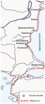 In the first millennium BC, on the territories
between Lower Danube and Haemus, a number of ancient Greek colonies developed along the west coast of the Black Sea, together with a certain number
of cities in the interior of Thracia.l. We can call
the western part of the Black Sea coast "the Thracian coast of Pontus Euxinus", since the region coincides with the concept Thracian coast of Ponta. The Thracians
were a significant part of the population in the territories of the ancient
Greek colonies and their territory. During the Hellenistic age, this region
was often under the political control of the Odrysian kingdom.
In the first millennium BC, on the territories
between Lower Danube and Haemus, a number of ancient Greek colonies developed along the west coast of the Black Sea, together with a certain number
of cities in the interior of Thracia.l. We can call
the western part of the Black Sea coast "the Thracian coast of Pontus Euxinus", since the region coincides with the concept Thracian coast of Ponta. The Thracians
were a significant part of the population in the territories of the ancient
Greek colonies and their territory. During the Hellenistic age, this region
was often under the political control of the Odrysian kingdom.
 The earliest Greek colonies were founded
in the last quarter of 7th c. BC from the city of Millet on the Asia Inferior coast of the Aegean Sea.
These are Histria (present-day ruins at the mouth of the Danube river, Romania). Tomis (Constanca,
Romania), Odessos (Varna, Bulgaria) and Apollonia (present-day Sozopol, Bulgaria).
The other colonies are Mesambria (Nessebar, Bulgaria), Anchialos (Pomorie), Dionisopolis (Balchik), Callatis
(Mangalia, Romania). These were Ionic colonies with the status of cities-poleis.
It is important to mention
that the Thracian king Teres, the first ruler from the Odrysian dynasty included
in the territories of the Odrysian kingdom the whole west Pontian coast from
the mouth of the Danube to Abdera at the Aegean shore. As the Greek historian
Thucydides writes (II, 29, 1; 29, 5), the colonies along the Aegean coast and
those along the west coast of the Black Sea were dependent on the Thracian
kings and paid them tribute. During the Hellenistic period these relations
periodically fell into crisis but until the Roman Age the region remained in
close economic relations with the interior of Thracia. The Odrysian kingdom
was the one that provided different supplies of cattle, timber, salted fish,
wax, honey, wheat and slaves for Greece and the East Mediterranean kingdoms
through the ports of the west Pontian and Aegean cities. It covered a huge territory from the mouth
of the Mesta river (Nestos) at Abdera to the northeast up to the mouth of the
Danube river (Thucydides, II, 97,1).
The earliest Greek colonies were founded
in the last quarter of 7th c. BC from the city of Millet on the Asia Inferior coast of the Aegean Sea.
These are Histria (present-day ruins at the mouth of the Danube river, Romania). Tomis (Constanca,
Romania), Odessos (Varna, Bulgaria) and Apollonia (present-day Sozopol, Bulgaria).
The other colonies are Mesambria (Nessebar, Bulgaria), Anchialos (Pomorie), Dionisopolis (Balchik), Callatis
(Mangalia, Romania). These were Ionic colonies with the status of cities-poleis.
It is important to mention
that the Thracian king Teres, the first ruler from the Odrysian dynasty included
in the territories of the Odrysian kingdom the whole west Pontian coast from
the mouth of the Danube to Abdera at the Aegean shore. As the Greek historian
Thucydides writes (II, 29, 1; 29, 5), the colonies along the Aegean coast and
those along the west coast of the Black Sea were dependent on the Thracian
kings and paid them tribute. During the Hellenistic period these relations
periodically fell into crisis but until the Roman Age the region remained in
close economic relations with the interior of Thracia. The Odrysian kingdom
was the one that provided different supplies of cattle, timber, salted fish,
wax, honey, wheat and slaves for Greece and the East Mediterranean kingdoms
through the ports of the west Pontian and Aegean cities. It covered a huge territory from the mouth
of the Mesta river (Nestos) at Abdera to the northeast up to the mouth of the
Danube river (Thucydides, II, 97,1).
 One of the most impressive among the west
Pontian cities is the ancient Greek colony Odessos. The city was founded by citizens from Millet in Asia Inferior in 6th c. BC.
It was ruled by a city council (gr. βουλη) and a National Assembly (gr. δημος).
It expanded quickly and developed into a large city centre. In 6th – 5th c. BC it traded actively with Millet, Rodos, Hios, Samos, Tassos, and Athens.
In 4th c. BC Odessos prospered economically and culturally. Coins were minted here from the middle of 4th c. BC on ( Fig. 5 ) Phf02BG-html. The Odessos coins can be found far to the west in the interior of the Thracian
lands between the Lower Danube and Haemus and this clearly shows the trade
and exchange routes within the region in question. The Romans appeared in Odessos
in 72/71 BC when Marcus Lucullus, the ruler of province Macedonia undertook his campaign to the west coast of
the Black Sea and ravaged the Greek colony Apolonia (Sozopol). There is no
direct evidence about Odessos’s fate from those times but probably the city
was not affected by the Roman attacks. A little later the Roman armies attacked
another Greek colony, Histria, at the mouth of the Danube River. Thus, the
settlement of the Romans in the region of the west Black Sea dates back to
the middle or second half of 1st c. BC, most probably after the campaigns of Marcus Lucinius Crassus in 29 and 28 BC. Initially the west Pontian cities were attached to province
Macedonia and had the status of civitates föderatä, which meant that these economically important centres preserved their independent
internal city government and no Roman military units were located there. When
the Moesia province was founded in 12 – 15 AD, the Black Sea city union was
transferred administratively to the Moesia province and remained within it
until the end of 3rd c. AD.
One of the most impressive among the west
Pontian cities is the ancient Greek colony Odessos. The city was founded by citizens from Millet in Asia Inferior in 6th c. BC.
It was ruled by a city council (gr. βουλη) and a National Assembly (gr. δημος).
It expanded quickly and developed into a large city centre. In 6th – 5th c. BC it traded actively with Millet, Rodos, Hios, Samos, Tassos, and Athens.
In 4th c. BC Odessos prospered economically and culturally. Coins were minted here from the middle of 4th c. BC on ( Fig. 5 ) Phf02BG-html. The Odessos coins can be found far to the west in the interior of the Thracian
lands between the Lower Danube and Haemus and this clearly shows the trade
and exchange routes within the region in question. The Romans appeared in Odessos
in 72/71 BC when Marcus Lucullus, the ruler of province Macedonia undertook his campaign to the west coast of
the Black Sea and ravaged the Greek colony Apolonia (Sozopol). There is no
direct evidence about Odessos’s fate from those times but probably the city
was not affected by the Roman attacks. A little later the Roman armies attacked
another Greek colony, Histria, at the mouth of the Danube River. Thus, the
settlement of the Romans in the region of the west Black Sea dates back to
the middle or second half of 1st c. BC, most probably after the campaigns of Marcus Lucinius Crassus in 29 and 28 BC. Initially the west Pontian cities were attached to province
Macedonia and had the status of civitates föderatä, which meant that these economically important centres preserved their independent
internal city government and no Roman military units were located there. When
the Moesia province was founded in 12 – 15 AD, the Black Sea city union was
transferred administratively to the Moesia province and remained within it
until the end of 3rd c. AD.
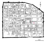
 A limited number of cities have been studied
archaeologically in the interior of pre-Roman Thracia, which was later included
in the provinces Moesia Superior and Moesia Inferior. This does not mean that
there were no such cities. Some of the centres of the local population had
urban elements as early as 6th c. BC. They occupied a central location among the other forms of settlements.
No city functions can be found in the other settlements. They are distinguished
from the surrounding settled areas in terms of their structure of construction,
architecture and principles of organization of life. In addition, they had
a leading government role with regard to the other forms of settlement. From
the map it becomes clear that the number of cities in pre-Roman Thracia is far from small. (Fig. 6) MapIIBG01 – html. Many more of them are known in the southern Thracian territories than in the
region between the Carpathians and Haemus (Stara planina), where there are
archaeological data only about three settlements with indications of a city.
These are Cotofeni din Dos, in Romania, the Thracian Gaetae centre near Sboryanovo
village in northeast Bulgaria and the Shumen fortress
A limited number of cities have been studied
archaeologically in the interior of pre-Roman Thracia, which was later included
in the provinces Moesia Superior and Moesia Inferior. This does not mean that
there were no such cities. Some of the centres of the local population had
urban elements as early as 6th c. BC. They occupied a central location among the other forms of settlements.
No city functions can be found in the other settlements. They are distinguished
from the surrounding settled areas in terms of their structure of construction,
architecture and principles of organization of life. In addition, they had
a leading government role with regard to the other forms of settlement. From
the map it becomes clear that the number of cities in pre-Roman Thracia is far from small. (Fig. 6) MapIIBG01 – html. Many more of them are known in the southern Thracian territories than in the
region between the Carpathians and Haemus (Stara planina), where there are
archaeological data only about three settlements with indications of a city.
These are Cotofeni din Dos, in Romania, the Thracian Gaetae centre near Sboryanovo
village in northeast Bulgaria and the Shumen fortress
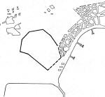
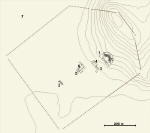
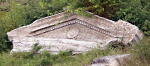
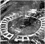
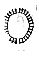
 As an example of a Thracian city we will
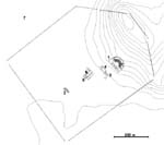
review the one from the site "Water station" near Sboryanovo village, with the probable name of Helis or Dausdava. It is assumed that this was the Gaetae capital of Dromichaetes, the victor of
Lizimah. It was located on a plateau, naturally protected on three sides by
a river and steep shores. During the second half of 4th c. BC the city was fortified with a massive wall. Its territory was about 10 hectares and it enclosed a triangular space. Walls
were built across the fortress wall and along the slope, which blocked the
hill from the valley. The construction was implemented with coarsely processed
stones kept together with clay. According to the researchers, the clay was
baked during its sequential laying in layers. This construction technique is
defined as local and is significantly different from the construction of the
fortifications in the ancient Greek colonies along the Black Sea coast. Near
the southern gate there was a temple of the goddess Artemis-Phosphorus, protector
of the cities. The central part of the fortified area was occupied by streets
and houses. Different crafts developed in the city: metal working, pottery,
bone items. Helis maintained trade relations with the cities along the west
coast of the Black Sea, as well as with many of the centres in the East Mediterranean
and Greece – the islands of Tassos, Rhodos, Koss, and Attica. There was a mint for making coin imitations. The biggest Gaetae cult centre was
near the city. It was about 40km to the south of the Danube River and 120km
away from the Black Sea. It was located in a very beautiful area and united
a number of cult sites, fenced with walls, as well as sanctuaries. Some of
them were cut into the rock reefs of the hilly plain. The city was destroyed
by a strong earthquake around the middle of 3rd c. BC. Probably the earthquake also marks the fall of many of the west-Pontian
cities-poleis, as well as of other Thracian cities.
As an example of a Thracian city we will
review the one from the site "Water station" near Sboryanovo village, with the probable name of Helis or Dausdava. It is assumed that this was the Gaetae capital of Dromichaetes, the victor of
Lizimah. It was located on a plateau, naturally protected on three sides by
a river and steep shores. During the second half of 4th c. BC the city was fortified with a massive wall. Its territory was about 10 hectares and it enclosed a triangular space. Walls
were built across the fortress wall and along the slope, which blocked the
hill from the valley. The construction was implemented with coarsely processed
stones kept together with clay. According to the researchers, the clay was
baked during its sequential laying in layers. This construction technique is
defined as local and is significantly different from the construction of the
fortifications in the ancient Greek colonies along the Black Sea coast. Near
the southern gate there was a temple of the goddess Artemis-Phosphorus, protector
of the cities. The central part of the fortified area was occupied by streets
and houses. Different crafts developed in the city: metal working, pottery,
bone items. Helis maintained trade relations with the cities along the west
coast of the Black Sea, as well as with many of the centres in the East Mediterranean
and Greece – the islands of Tassos, Rhodos, Koss, and Attica. There was a mint for making coin imitations. The biggest Gaetae cult centre was
near the city. It was about 40km to the south of the Danube River and 120km
away from the Black Sea. It was located in a very beautiful area and united
a number of cult sites, fenced with walls, as well as sanctuaries. Some of
them were cut into the rock reefs of the hilly plain. The city was destroyed
by a strong earthquake around the middle of 3rd c. BC. Probably the earthquake also marks the fall of many of the west-Pontian
cities-poleis, as well as of other Thracian cities.
There are still no certain archaeological data about the cities in the interior of Thracia between the Danube and Haemus. The reason for this is not only the limited archaeological studies, but also the great dynamics of migration in the region in the period between 3rd and 1st c. BC.
Thus, when the Romans arrived in the eastern part of the Balkan Peninsula, they found cities along the west coast of the Black Sea and in the interior of Thracia. Two types of cities can be distinguished in terms of their architecture and structure – the Greek colonies and the cities-centres of the local population – but both fell into decline at the beginning of the Roman conquest of the Balkans and the formation of the Roman provinces.
Gergana Kabakchieva
Chichikova, M. – Чичикова, М. Свещарската гробница - архитектура и декорация. – Terra Antiqua Balcanica III. София, 1988, 125 – 143.
Danov, Hr. – Данов, Хр. Древна Тракия. София, 1968.
Fol, Al. – Фол, Ал. Политическа история на траките от края на II хил. до V в.пр.н.е. София, 1972.
Fol, Al. – Фол Ал., Политика и култура в древна Тракия. София, 1990.
Fol, Al. – Фол. Ал., История на българските земи през Античността до края на III в.пр.н.е. София, 1997.
Fol, Al., Chicikova, M., Ivanov, Т., Teofilov, T. – The Thracian Tomb Near the Village of Sveshtari. Sofia, 1986.
Fol, Al., K.Jordanov, K.Poroyhanov, V.Fol. – Ancient Thrace, Sofia, 2000.
Gergova, D. – Гергова, Д. Сборяново. Свещената земя на гетите. София, 2004
History of Bulgaria ( edt. D.Kosev and o. ) - История на България, т. I, София, 1979.
Isaak, B. – The Greek Settlements in Thrace until the MacedinianConquest. Brill. Leiden, 1986.
Jordanov K. - Entstehung und Charakter des Staates bei den Thrakern. – Thracia 9, 31 – 52.
Marazov, I. – Маразов, И. За семантиката на изображенията в гробницата от
Свещари. Изкуство, 1984, 4, 28 – 38.
Marazov, I. - Маразов, И. Древна Тракия, изд. ”Летера”, Пловдив, 2005.
Popov, Hr. – Попов, Хр. Урбанизация във вътрешните райони на Тракия и Илирия през VI - I век преди Христа. София, 2002.
Stoyanov, T. – Стоянов, Т. Тракийският град в Сборяново, София, 2000.
Velkov, V. – Велков, В. Античният живот в тракийските селища – Klio, 62, 1980, p. 5 sq.
 In
the province of Moesia, settlements with the status of Roman colonies appeared in the 1st c. - beginning of 2nd c. AD. They were not secceeded the older thracian capital of civitas. The colonies
were built of the Romans as a type of "deductive colonies", i.e. founded by veterans from the Roman army. The civil founders were the settlers
from other regions of the Roman Empire and a smaller number of native people.
The citizens of the colonies Scupi/CF Scupi, Ratiaria/CU Ratiaria and Oescus/CU
Oescensium played an important role in the establishing of the Roman culture
in the provinces Moesia Superior and Moesia Inferior.
In
the province of Moesia, settlements with the status of Roman colonies appeared in the 1st c. - beginning of 2nd c. AD. They were not secceeded the older thracian capital of civitas. The colonies
were built of the Romans as a type of "deductive colonies", i.e. founded by veterans from the Roman army. The civil founders were the settlers
from other regions of the Roman Empire and a smaller number of native people.
The citizens of the colonies Scupi/CF Scupi, Ratiaria/CU Ratiaria and Oescus/CU
Oescensium played an important role in the establishing of the Roman culture
in the provinces Moesia Superior and Moesia Inferior.
 Colony
Scupi/ Scupinorum, Colonia Flavia Scupi (Scupinorum) (at the city of Skopje, Republic of Macedonia) is founded during the rule of
the Flavius dynasty, around 75 AD. The full name of the city has been
preserved on a inscription from the time of Emperor Domitian: Col(oniae) F(laviae) f(elix) D(omitiana). The colony was organized by veterans from the following legions: first, from legio VII Claudia, legio V Macedonica, legio I Italica, legio IV Macedonica,
legio IV Flavia, i.e. it is "deductive".
Colony
Scupi/ Scupinorum, Colonia Flavia Scupi (Scupinorum) (at the city of Skopje, Republic of Macedonia) is founded during the rule of
the Flavius dynasty, around 75 AD. The full name of the city has been
preserved on a inscription from the time of Emperor Domitian: Col(oniae) F(laviae) f(elix) D(omitiana). The colony was organized by veterans from the following legions: first, from legio VII Claudia, legio V Macedonica, legio I Italica, legio IV Macedonica,
legio IV Flavia, i.e. it is "deductive".
After the Romans conquered Macedonia
(146 BC), this was the location of the permanent camp of the two Roman
legions legio V Macedonica and legio IV Schytica. As a result of the latest studies at the Lower Danube Limes, where the results
of the newest archaeological excavations show that in late Augustian times
these two legions were already dislocated at Lower Danube: legio V Macedonica with a permanent camp in Oescus (at the village of Gigen, Bulgaria) and legio IV Schytica with a permanent camp in Viminatium (Kostolac, Republic of Serbia) or in Ratiaria (village of Archar, Republic of
Bulgaria). The exact location of the camp in Scupi has not been located
yet. It is also not known which military units resided here after the two
legions were moved to Lower Danube.
 The
Roman colony Scupi is located in the northwestern periphery of the city of Skopje (Republic Macedonia),
on the slightly inclined terrain of the hill “Zaychi Rid“. The Vardar River
is to its east. The city covers 42 hectares of fortified area. Its shape is that of an irregular hexagon. It has been found that the longitudinal axis of the city is in the direction
northeast - southwest. The first archaelogical studies here were carried
out by the famous English archaeologist А.Evans at the end of 19th c. Although there have been different periods of interruption, studies of the
colony continue to this day .
The
Roman colony Scupi is located in the northwestern periphery of the city of Skopje (Republic Macedonia),
on the slightly inclined terrain of the hill “Zaychi Rid“. The Vardar River
is to its east. The city covers 42 hectares of fortified area. Its shape is that of an irregular hexagon. It has been found that the longitudinal axis of the city is in the direction
northeast - southwest. The first archaelogical studies here were carried
out by the famous English archaeologist А.Evans at the end of 19th c. Although there have been different periods of interruption, studies of the
colony continue to this day .
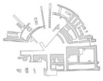
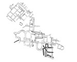
 From
the internal buildings, the following have been studied: an ancient theatre,
a civil basilica, a city villa, thermae, a storehouse for grain, early Christian basilica. The main street is in the direction north - south. During the period from the end of 1st c. AD until the beginning of the 3rd c. the city was flourishing. One of the best preserved ruins in the city are
these of ancient theatre. The eastern and western necropolises of the ancient city have been partially investigated.
From
the internal buildings, the following have been studied: an ancient theatre,
a civil basilica, a city villa, thermae, a storehouse for grain, early Christian basilica. The main street is in the direction north - south. During the period from the end of 1st c. AD until the beginning of the 3rd c. the city was flourishing. One of the best preserved ruins in the city are
these of ancient theatre. The eastern and western necropolises of the ancient city have been partially investigated.
 |
 |
The defences walls are made of
stone, constructed in the opus quadratum emplectum technique, and 3.20 m wide. The fossa is 6,0 m wide and runs in front of the wall.
The location of the colony on
the crossroad of important trade routes from the Danube to the Aegean and
from the provinces Moesia and Thracia to Brindisi and Italy was contributed
for its prosperity. The Vardar River was been an other transport way for
the city.
Monuments from Scupi can be seen in the National Museum in Skopje.´
The
roman colony Ratiaria, Colonia Ulpia Traiana Ratiaria (at the village of Archar, Republic of Bulgaria) of the province Moesia Superior was founded in 106 AD, probably of the vicus of the military camp. It was being after the victorious Second Dacian War of
Emperor Trajan, when the northeast border of the Roman Empire was moved
from Lower Danube to the Carpathian mountains. The full name of the city
is Colonia Ulpia Traiana Ratiaria. It is witnessed for the first time on an inscription from 125 AD. The common
belief for the etymology of the name is that comes from the Latin word
for a type of river boats - ratis. It is a deductive colony which was founded by veterans, and did not inherit
an older Thracian settlement. In addition to the veterans, among the founders
of Ratiaria were settlers from Italy and other Roman provinces.
In the 1st c. AD different subdivisions of the Roman army had their permanent camp here. The earliest information about Roman military presence date back to the rule of Emperor Tiberius, when cohors I Gallorum camped to the mouth of the Archaritza River. Probably there was the permanent camp of some units of legio IV Flavica and legio VII Claudia also.
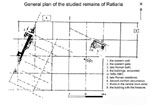
 The
colony Ratiaria is located on the high right bank of the Danube River,
west of the village of Archar (Republic Bulgaria). The terrain is inclined
to the south; east-southeast The territory of Ratiaria colony covered a
significant area from Timok River to Tsibritsa River and from the Danube
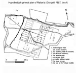
River to the Balkan mountains. The area of the city is approximately defined at 850 х 450 m /according to G. Giorgetti, 1987. In
2nd and 3rd centuries the city developed as one of the most prosperous at the Lower Danube
with a rather Romanized population due to the fertile land and the presence
of ore. It had an autonomous government following the Italic model. Ratiaria
was an important customs point and the biggest production and trade centre
in the province Moesia Superior as well. There was a station of portorium Illyrici here.
The
colony Ratiaria is located on the high right bank of the Danube River,
west of the village of Archar (Republic Bulgaria). The terrain is inclined
to the south; east-southeast The territory of Ratiaria colony covered a
significant area from Timok River to Tsibritsa River and from the Danube
River to the Balkan mountains. The area of the city is approximately defined at 850 х 450 m /according to G. Giorgetti, 1987. In
2nd and 3rd centuries the city developed as one of the most prosperous at the Lower Danube
with a rather Romanized population due to the fertile land and the presence
of ore. It had an autonomous government following the Italic model. Ratiaria
was an important customs point and the biggest production and trade centre
in the province Moesia Superior as well. There was a station of portorium Illyrici here.
 The
building materials used for construction in Ratiaria, which was promoted
to colony in the beginning of the 2nd c. AD, are stone and bricks. The systematic excavations began in the 1950s.
From 1978 to 1991, Bulgarian-Italian excavations were carried out at Ratiaria.
The team included archaeologists from the Institute of Archaeology with
a Museum at Bulgarian Academy of Sciences and Bologna University (Italy).
The
building materials used for construction in Ratiaria, which was promoted
to colony in the beginning of the 2nd c. AD, are stone and bricks. The systematic excavations began in the 1950s.
From 1978 to 1991, Bulgarian-Italian excavations were carried out at Ratiaria.
The team included archaeologists from the Institute of Archaeology with
a Museum at Bulgarian Academy of Sciences and Bologna University (Italy).
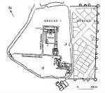
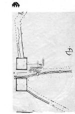
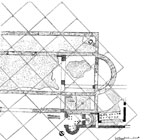
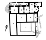
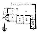
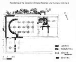 In
the south-western part of the city, a large building with mosaics and murals
has been studied. That was probably the palace of one of the provincial governors from 4th c. AD (Fig. 10) Pln05En-html From the earliest city plan, part of the main street
has been partially discovered - decumanus maximus at the west gate. To the northwest of the city, part of a suburb villa with mosaics
(domus suburbana) and an early Christian basilica have been studied. South of the town is located
one large thermae. Excavations at the necropolises of the colony have not
been carried out. The information on them comes from accidental finds.
In
the south-western part of the city, a large building with mosaics and murals
has been studied. That was probably the palace of one of the provincial governors from 4th c. AD (Fig. 10) Pln05En-html From the earliest city plan, part of the main street
has been partially discovered - decumanus maximus at the west gate. To the northwest of the city, part of a suburb villa with mosaics
(domus suburbana) and an early Christian basilica have been studied. South of the town is located
one large thermae. Excavations at the necropolises of the colony have not
been carried out. The information on them comes from accidental finds.
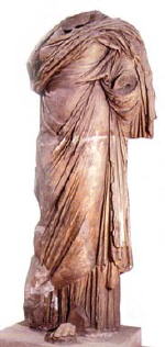
A number of monuments from the city and the surrounding area provide evidence for the prosperity of the citizens of Ratiaria during the Roman Age. There were found remarkable achievements of the ancient marble and bronze sculpture, as well as sarcophagi, some of which with a rich plastic decoration. During the Roman Age Ratiaria developed as one of the biggest centres of arts and crafts and other industries in the area of the East Balkans. It was a trade centre with closer and more remote regions in the Roman Empire. The presence of precious metals within the territory of Ratiaria colony contributed to the development of big jewelry workshops.
 |
 |
 |
 |
During the administrative-territorial reform in 272 Ratiaria was proclaimed the capital of the province Dacia Ripensis and remained one of the most prospering cities until the end of Antiquity. As a result of the devastating treasure-hunters’ destruction in the last ten years, only a little can be seen on site from the Roman colony.
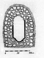
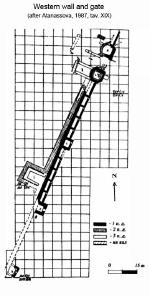 Parts
of the western fortification system and the west gate have been studied. That was the main city gate with dimensions 7.60 х 5.00 m
and the width of its passage is 5.40 m. The gate-towers are sevensides.
They are projected to in- and outside of the wall.
Parts
of the western fortification system and the west gate have been studied. That was the main city gate with dimensions 7.60 х 5.00 m
and the width of its passage is 5.40 m. The gate-towers are sevensides.
They are projected to in- and outside of the wall.
The primary town defences has been built of stone blocks in opus quadratum empletum and opus vitatum..It was being of two parts with a common wight of 3,85 m. The towers were projected to inside of it and their shape is rectangular. Each of them has been built of 31,0 to 33,50 m one of other.The stone defence system of Ratiaria was being build in the beginning of 2 c.AD. At the end of the 3.c. AD it has been reconstructed and the new wall with a width of 2,00 m was built at the front of the older in opus mixtum.
The cult of the main Roman god Iupiter Optimus Maximus was wide-spread in the city and its territory. Other cults were also common here: such as those of Hercules, Mithras, Venus, Fortuna, and Fortuna-Isis, Diana, Appolo. In the region of fore mountain of the Balkan mountains became a wide-spread the cult of a god Silvanus, the defender of the forests, the herdsmen and the woodcutters.In this region were found more votive monuments of the Thracian horseman, too.
Monuments and finds from Ratiaria are kept in the Historical Museum in the city of Vidin, in the National Archaelogical Museum and the National Museum of History in Sofia.
 Oescus/
Colonia Ulpia Oescensium ( Gradishte area, west of the village of Gigen, Republic of Bulgaria) a Roman
deductive colony in the province Lower Moesia (Moesia Inferior).It was
founded in 106 AD by veterans of legio V Macedonica and legio I Italica,
as the colonists from different Roman provinces. The full name of the
city is Colonia Ulpia Oescus. The name of the colony is mentioned for
the first time in an inscription from the times of Emperor Hadrian. The
fortified city has the shape of an irregular pentagon, with an initial
area of 18 hectares, and after 271 it was extended with 10 ha in the
east direction. The first archaeological excavations in Oescus were carried
out by Vaclav Dobruski in 1904 – 1905 and with the different breaks continue
till now.
Oescus/
Colonia Ulpia Oescensium ( Gradishte area, west of the village of Gigen, Republic of Bulgaria) a Roman
deductive colony in the province Lower Moesia (Moesia Inferior).It was
founded in 106 AD by veterans of legio V Macedonica and legio I Italica,
as the colonists from different Roman provinces. The full name of the
city is Colonia Ulpia Oescus. The name of the colony is mentioned for
the first time in an inscription from the times of Emperor Hadrian. The
fortified city has the shape of an irregular pentagon, with an initial
area of 18 hectares, and after 271 it was extended with 10 ha in the
east direction. The first archaeological excavations in Oescus were carried
out by Vaclav Dobruski in 1904 – 1905 and with the different breaks continue
till now.
The city was established on the place of the early Roman legionary camp of legio V Macedonica, which was positioned here 9 AD, i.e. in late Augustan times. The legion camped out at the mouth of the River Iskar (ancient Oescus) till the end of the First Dacian War of the Emperor Trajan in 102 AD. The legionary camp is with the shape of a irregular pentagon. The remains of the earliest defence system are not yet discovered (earth-wooden). The preserved part of the second fortification wall of the legionary camp of Oescus is found in the southern area. It is of stone-earth erected and date back of the beginning of the rule of the Flavian Dynasty (71-72 AD). Some parts of the soldier’s wood-houses from first and second half of 1.c. AD are studied.
In 271 legio V Macedonica returned to camp in Oescus and this leaves its mark on the further history and culture of the city, which existed until the end of 6th c. AD.
The Roman colony Oescus is located at 3 km southern of the mouth of the River Iskar (Oescus) in the Danube.It was built in the most fertile region of the Danube plain.The territory of the colony stretches to the west from Tsibrica River (Ciabrus) to Ossam River (Assamus) to the east and from the Danube River to the fore-mountain range of the Balkan mountains by the epigraphical data, which is not much. The western borders of the territory are defined with a fair approach to accuracy.
 |
 |
 |
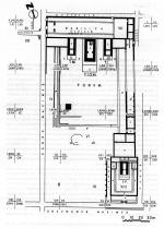
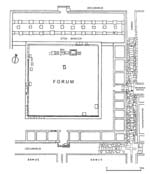
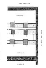
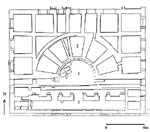
As a result of the long excavations, the following have been discovered: large parts of the fortification walls, the west main gate of the city, towers, streets, the forum, thermae, shops, and workshops. 2/3 of the Forum area have been studied. Its area is 100 х60 m and a longitudinal axis in the direction north - south. To the north it was flanked by a civil basilica of impressive dimensions 100 х 27.0 m and a temple complex of three temples of the Capitolian Trinity (Iupiter, Iuno and Minerva). The construction of the forum began during the rule of Emperor Trajan and continued under Hadrian. Famous architects and civil engineers from the eastern Roman provinces took part in it. The architectural decoration of the forum is in the Roman-Corinthian order and is very close to that of the cities Ephessos in Asia Minor. East of it is excavated a building for walking during the winter, which is written on the gable of it To its south, a building with a black and white mosaic has been studied. In the southeast part of the forum, a temple of the goddess Fortuna has been entirely discovered. It was constructed in 190-193, in the Roman-Corinthian order. A large building, discovered south of the forum and the main street - decumanus maximus can be determined as belonging to the construction of 2nd c. During the 3rd century, the floor of one of its rooms was decorated with a multi-coloured mosaic, with a scene from “Ahaioi“ by the Greek play-writer Menander.
 |
 |
 |
 During
the Roman Age the colony Ulpia Oescus developed as a large production,
trade and cultural centre in the region of the Lower Danube. It was also
one of the biggest trade distribution centres for the inside of the province
Moesia Inferior.
During
the Roman Age the colony Ulpia Oescus developed as a large production,
trade and cultural centre in the region of the Lower Danube. It was also
one of the biggest trade distribution centres for the inside of the province
Moesia Inferior.
One of the biggest sculpture workshops in Moesia Inferior developed in Oescus. The only colossal statue that one can see in present-day Bulgaria was discovered here. It is a temple statue of the goddess Fortuna. In Oescus the following were manufactured: jewelry, bronze statuettes bronze brooches and other metal objects and vessels, glass, ceramics (terra sigillata, red slip pottery and other). The production of metal and bone articles was also developed.
 The
stone defensive wall was constructed during the rule of Emperor Trajan.
The technique used is opus quadratrum emplectum, and its original width
was 2.80 m. The remains of the west city gate, which is the main gate is
fully discovered. It is at the south-western corner of Oescus and it’s
dimensions are 21,45 x 6,85 m. On both sides of it there are a rectangular
tower. The passage between them is 7,00 m long and with 5,35 m width. The
fortification walls make turn after some distance after the gate. The full
width of them is 3,25 m. Except the towers by the west gate there are no
other which are discovered.
The
stone defensive wall was constructed during the rule of Emperor Trajan.
The technique used is opus quadratrum emplectum, and its original width
was 2.80 m. The remains of the west city gate, which is the main gate is
fully discovered. It is at the south-western corner of Oescus and it’s
dimensions are 21,45 x 6,85 m. On both sides of it there are a rectangular
tower. The passage between them is 7,00 m long and with 5,35 m width. The
fortification walls make turn after some distance after the gate. The full
width of them is 3,25 m. Except the towers by the west gate there are no
other which are discovered.
 An
important part of the city life was been the water-supply. The main water-reservoirs
have been made at 20 km southern of the colony by the village Orjachovitza.The
water has reached the town with the canal, built of stone and bricks(aqueduct).Some
part of it is preserved near the roman colony, but till now it is not found
a control-reservoir (castellum aquae).The water has run through the clay-pipes
and only by the entering in the city of a lead. At the different places
in Oescus have been discovered a control water-shaft. In Oescus there is
an other water-spring at the place"Dobroshina", which is 3 km south-eastern.
An
important part of the city life was been the water-supply. The main water-reservoirs
have been made at 20 km southern of the colony by the village Orjachovitza.The
water has reached the town with the canal, built of stone and bricks(aqueduct).Some
part of it is preserved near the roman colony, but till now it is not found
a control-reservoir (castellum aquae).The water has run through the clay-pipes
and only by the entering in the city of a lead. At the different places
in Oescus have been discovered a control water-shaft. In Oescus there is
an other water-spring at the place"Dobroshina", which is 3 km south-eastern.
In some of the public and private buildings there were found the wells, which are other water-supply of the living..
The main cult of Oescus was being the cult of the Capitolian Trinity Iupiter Optimus Maximus,Iuno and Minerva."The Capitolium" in Oescus consists of three separate temples with the yards between them. The goddess Fortuna was being recognized as a goddess-protectress of the colony and for her has been built a big and rich decorated temple on the south-eastern part of the forum. The worship of Mercurius, Mithras, Venus, Dyonissos, Appolo, Hekata, Isis and other gods, are registred by different finds. Very limited are the votive monuments of Thracian Horseman, except the southern part of the territory of the colony, where mainly lived a thracian population.
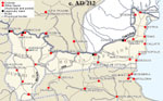
The city was situated on the cross road of several important roads: the Danube road from Singidunum (Belgrade) through Viminatium (Costolac) and Ratiaria to the Oescus. After the colony this road goes through Novae (Staklen by Svistov) and Durostorum (Silistra) to the mouth of the Danube River. The remains of this road by Oescus are registrated west of the city. Its width is 6,0 m.
Another important road is this from Oescus to Philippopolis (Plovdiv) in the province of Thracia. This road is one of the earliest, which is constructed in the province Moesia of the Romans in the time of the Emperor Nero (61 AD) of the soldiers of legio V Macedonica.
The transport connection to the south and Italy has been completed with the road from Oescus to Serdica (Sofia) and Scupi.Through the valley of the Strymon River the way goes to the Thessaloniki in Greece and Aegea. Another very important road was the one from Oescus to the province Dacia. It passes through the valley of Olt River to the north and reaches the Carpathian mountains.
To the excavations at Oescus there is a little exhibition. Mainly, the monuments of Oescus are in the Historical Museum in Pleven, in the National Archaeological Museum and National Historical Museum in Sofia. Oescus is one of the biggest and most continuously studied ancient cities of Lower Danube and is a place often visited by Bulgarian and foreign tourists.
Gergana Kabakchieva
Atanasova, J., A.Popova- Asenova , Il muro di cinta di Ratiaria,
lato occidentale. Ricerche archeologiche 1976-1985 .
Ratiariensia, 3-4 (Bologna) 1987, 85 - 96.
Dinchev, V. - Динчев, В. Рациария. – В: Римски и ранновизантийски градове вБългария, том I, (ред. Р. Иванов), София, 2002, 13-31.
Dragojeviae-Josifovska, B. Inscriptions de la Mesie superieure, vol. VI, Scupi et la region de Kumanovo. Beograd, 1982.
Georgetti, D. Colonia Ulpia Traiana Ratiaria: Analecta geographica ethistorica. –In: Ratiarensia 1, Bologna, 1980, 14-34;
Ivanov, T. Der Fortuna - Tempel in der Colonia Ulpia Oescensium in Moesia Inferior. – Известия на Археологическия институт XXXVII, 1987, 7-60.
Ivanov, T. Das Forum der Colonia Ulpia Oescensium (1980 - 1987). Die Architektur. – Roman Limes on the Middle and Lower Danube, Belgrade, 1996, 183-186.
Ivanov, T., Ivanov, R. - Иванов Т., Р. Иванов. Улпия Ескус. Римски и ранновизантийски град. т. I, София, 1998.
Ivanov, T. - Иванов, Т. Улпия Ескус. Римски, късноримски и ранновизантийски град. т. II, София, 2005 (= Разкопки и проучвания XXXIV).
Kabakchieva, G. - Кабакчиева, Г. Към въпроса за стратиграфията на Улпия Ескус по данни от археологическите разкопки през 1989 г. – Годишник на Националния археологически музей IX, 1993, 85-94.
Kabakchieva, G. - Кабакчиева, Г. Археологически данни за историята на Ескус. – В: III Международен симпозиум Кабиле. Поселищен живот в древна Тракия. Ямбол, 1994, 148-170.
Kabakchieva, G. - Кабакчиева, Г. Oescus I. Castra Oescensia. Ранноримският военен лагер при устието на р. Искър, София, 2000.
Kabakchieva, G. Frührömische Militärlager in Oescus (Nordbulgarien). Ergebnisse und Ausgrabungen (1989- 1993). -Germania 74, 1996, 1, 95-117.
Coracevic, D. - Коракевик. Д. Скупи. Градска територия. Скопjе, 2002.
Miculcic, I. - Микулчик, И. Скопje цо околните тврдини. Скопje, 1982.
Mocsy, А. Gesellschaft und Romanisation in der Römischen Provinz Moesia Superior. Budapest, 1970, 62-75.
Mocsy, A.. Pannonia and Upper Moesia, A History of the Middle Danube Provinces of the Roman Empire, London, 1974.
Tabula Imperi Romani K34 (Naissus-Dyrrhachion-Scupi-Serdica-Tessalonike), Ljubljana, 1976.
Velkov, V. Ratiaria, eine roemische Stadt in Bulgarien. – Eirene 5, 1966, 155-172.
 One
of the most characteristic forms of Roman construction in the central city
part is the basilica civilis. This type of buildings usually has an elongated plan. It was imposed by their
functions - buildings for public, trade and legal contacts. The earliest
basilicas in the province Moesia (Moesia Superior and Moesia Inferior) which have been studied date back to the first half of 2nd century AD. In the province Moesia Superior was researched the basilica in roman colony Skupi. Such buildings from Moesia Inferior which have been studied are also few. They
were known from roman colony Ulpia Oescus by Gigen and from Nicopolis ad Istrum in Bulgaria and from Tropaeum Traiani in Romania. The civil basilica in Ulpia Oescus is not only completely studied, it is the most decorated in the province. This
is why it will be presented as an example of this type of construction
in Moesia Inferior.
One
of the most characteristic forms of Roman construction in the central city
part is the basilica civilis. This type of buildings usually has an elongated plan. It was imposed by their
functions - buildings for public, trade and legal contacts. The earliest
basilicas in the province Moesia (Moesia Superior and Moesia Inferior) which have been studied date back to the first half of 2nd century AD. In the province Moesia Superior was researched the basilica in roman colony Skupi. Such buildings from Moesia Inferior which have been studied are also few. They
were known from roman colony Ulpia Oescus by Gigen and from Nicopolis ad Istrum in Bulgaria and from Tropaeum Traiani in Romania. The civil basilica in Ulpia Oescus is not only completely studied, it is the most decorated in the province. This
is why it will be presented as an example of this type of construction
in Moesia Inferior.

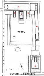
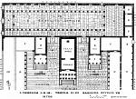
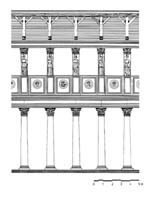
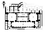
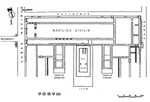 The
civil basilica in Ulpia Oescus is in the northern part of the forum. It was studied archaeologically during the 1970s. The civil basilica in Oescus is the longest public building from Antiquity which has been discovered of the
province Moesia. Its dimensions are: length - 97.60 m and width - 23.5
m. The basilica is a three-nave one and its official entrance is from the west, where one of
the main city streets passes - cardo maximus. Each of its naves had a separate entrance. In the northeast part of the building
there was a smaller service entrance. The building was constructed from
limestone small blocks. On the inside and outside the walls were covered
with a fine plaster. Along the northern internal wall there are semi-round
and rectangular bays, where bronze and marble statues of Roman emperors,
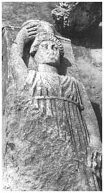
province governors, eminent citizens of Oescus and different deities were placed. During the excavations of the terrain of
the basilica and next to it, a marble statue of Apollo and a marble head
from a statue of the goddess Venus were found. These two are exceptional
pieces of ancient art from 2nd century AD. The north fence of the temple complex of the Capitolian Triad was
used as the south wall of the building. The widest is the middle nave of
the basilica - 11.60 m, the others are 3.60 m wide. It is entered through
a two-wing door and an antechamber. Only this nave had two floors and its
upper part provided light to the interior of the basilica. On the first
floor there were tall limestone columns with roman-corinthian capitals
and richly decorated frieze-architraves. An inscription was engraved on
part of the frieze in honor of Emperor Hadrian (117-138), the time when
the basilica was constructed. A small but very significant in terms of
dating part survived from it [I]MP.II.C = IMP(eratori) II C[O(n)S(uli). The construction of the basilica has thus been dated between 135 and 138 AD.
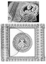
The gallery of the second floor was decorated with figures of young women, bearing baskets with fruits on their heads in high relief (caryatids). Their
figures played the role of pilaster columns. Under them, also serving as
railing, were large rectangular panels with medallions in the middle. The images in the medallions are diverse Silenus, a male head, a female head, an actor with a mask in his
hand or the images of the famous citizens and roman imperators
The
civil basilica in Ulpia Oescus is in the northern part of the forum. It was studied archaeologically during the 1970s. The civil basilica in Oescus is the longest public building from Antiquity which has been discovered of the
province Moesia. Its dimensions are: length - 97.60 m and width - 23.5
m. The basilica is a three-nave one and its official entrance is from the west, where one of
the main city streets passes - cardo maximus. Each of its naves had a separate entrance. In the northeast part of the building
there was a smaller service entrance. The building was constructed from
limestone small blocks. On the inside and outside the walls were covered
with a fine plaster. Along the northern internal wall there are semi-round
and rectangular bays, where bronze and marble statues of Roman emperors,
province governors, eminent citizens of Oescus and different deities were placed. During the excavations of the terrain of
the basilica and next to it, a marble statue of Apollo and a marble head
from a statue of the goddess Venus were found. These two are exceptional
pieces of ancient art from 2nd century AD. The north fence of the temple complex of the Capitolian Triad was
used as the south wall of the building. The widest is the middle nave of
the basilica - 11.60 m, the others are 3.60 m wide. It is entered through
a two-wing door and an antechamber. Only this nave had two floors and its
upper part provided light to the interior of the basilica. On the first
floor there were tall limestone columns with roman-corinthian capitals
and richly decorated frieze-architraves. An inscription was engraved on
part of the frieze in honor of Emperor Hadrian (117-138), the time when
the basilica was constructed. A small but very significant in terms of
dating part survived from it [I]MP.II.C = IMP(eratori) II C[O(n)S(uli). The construction of the basilica has thus been dated between 135 and 138 AD.
The gallery of the second floor was decorated with figures of young women, bearing baskets with fruits on their heads in high relief (caryatids). Their
figures played the role of pilaster columns. Under them, also serving as
railing, were large rectangular panels with medallions in the middle. The images in the medallions are diverse Silenus, a male head, a female head, an actor with a mask in his
hand or the images of the famous citizens and roman imperators
 |
 |
 |
The civil basilica in Ulpia Oescus survived for more than two centuries. It underwent a number of reconstructions and repairs during this long period. It was destroyed by a fire during the Goths invasion in 376-378.
 The
other civil basilica from the province Moesia Inferior was the basilica
from the city of Nicopolis ad Istrum. This city was administratively included in the province as late as 193 AD.
Initially the basilica in Nicopolis ad Istrum was constructed as a portico or stoa, following those in the Roman cities in Asia Minor - Ephessus, Smirna, etc. Most probably its reconstruction into a civil three-nave basilica took
place when the city became part of the territory of province Moesia Inferior
at the end of the second century AD.
The
other civil basilica from the province Moesia Inferior was the basilica
from the city of Nicopolis ad Istrum. This city was administratively included in the province as late as 193 AD.
Initially the basilica in Nicopolis ad Istrum was constructed as a portico or stoa, following those in the Roman cities in Asia Minor - Ephessus, Smirna, etc. Most probably its reconstruction into a civil three-nave basilica took
place when the city became part of the territory of province Moesia Inferior
at the end of the second century AD.
 It
is situated in the north part of the forum of the Roman town . Its dimensions are 67.40 х19.45 m. Few of the elements of the building’s architectural
decoration have been preserved. The building had a thick wall only on the
north side. On the south one it was open towards the open air square (area). Like the other part of the forum, the basilica is decorated in the Roman-Ionic
style. The frieze-architrave blocks have a relief decoration of acanthus
leaves with different images between them. On one of the blocks has been
partially preserved a building inscription of the forum in Greek language,
because it was the official in the province Thracia. It shows that the construction
of the centre of Nicopolis ad Istrum took place in the period between 117 and 138, i.e. during the rule of Emperor
Hadrian (117-138). According to the researchers of the basilica, it was rebuilt into a three-nave one in the third construction period, which means in the last quarter of the 2nd century AD. However, as a stoa it also had the functions of a civil basilica.
It
is situated in the north part of the forum of the Roman town . Its dimensions are 67.40 х19.45 m. Few of the elements of the building’s architectural
decoration have been preserved. The building had a thick wall only on the
north side. On the south one it was open towards the open air square (area). Like the other part of the forum, the basilica is decorated in the Roman-Ionic
style. The frieze-architrave blocks have a relief decoration of acanthus
leaves with different images between them. On one of the blocks has been
partially preserved a building inscription of the forum in Greek language,
because it was the official in the province Thracia. It shows that the construction
of the centre of Nicopolis ad Istrum took place in the period between 117 and 138, i.e. during the rule of Emperor
Hadrian (117-138). According to the researchers of the basilica, it was rebuilt into a three-nave one in the third construction period, which means in the last quarter of the 2nd century AD. However, as a stoa it also had the functions of a civil basilica.
It was discovered and researched the civil basilica (basilica
forensis) in Tropaeum Traiani in Romania. The town was founded in the period of 106-109 AD. And it has prospered during
the 2nd - 3rd century as a settlement near the famous memorial monument "Tropaeum Traiani". The basilica is located at the main street (via principalis). Probably it was built in the first period of the establishment of the town, and later in the 4th century was been rebuilt and used till end of the 6th century AD.
 |
 |
 |
 |
There were civil basilicas in the other cities of the provinces Moesia Superior and Moesia Inferior, but there are still not archaeological data about them.
Gergana Kabakchieva
Ivanov, T., Ivanov, R. - Иванов, T., Р.Иванов. Никополис ад Иструм (Nicopolis ad Istrum, vol. I, Sofia 1994, 70-73) Т. I, София, 1994, 70-73.
Kabakchieva, G. - Кабакчиева, Г. Към въпроса за стратиграфията на Улпия Ескус по данни от археологическите проучвания през 1989 г. - Годишник на Националния Археологически музей, IX, 1993, 85-94. (About the stratigraphy of Ulpia Oescus of the excavation’s date from 1989. - Annuary of the National Museum of Archaeology, vol. IX, 1993, 85-94).
Kabakchieva, G. - Кабакчиева, Г. Археологически данни за римската история на Ескус. - В: III Международен симпозиум Кабиле. Поселишен живот в древна Тракия. Ямбол, 1994, 148-170 (Archaeological Evidence about the roman history of Oescus. – In: III International Conference Cabyle. The Settlement’s Life in the Ancient Thrace, Yambol, 1994, 148-170).
Slokoska, L., Vladkova, P., Carov, I., Boyadgiev, S., Ivanov, R. - Л.Слокоска, П.Владкова, И.Църов, Ст. Бояджиев, Р.Иванов. Никополис ад Иструм. – В: Римски и ранновизантийски градове в България (ред. Р.Иванов), т. I, София, 2002, 83-104 (Nicopolis ad Istrum. – In: Roman and Early Byzantine Cities in Bulgaria, vol. I, Sofia, 2002, 83-104).
Al.Barnea, I.Barnea, I.B.Cataniciu, M.Margineanu-Carstoiu, G. Papuc, Tropeum Traiani I. Cetatea, Bucuresti, 1979.
T.Ivanov, Untersuchungen des Forumkomplexes in der Colonia Ulpia Oescensium (1975 – 1979). – Roman Frontier Studies (BAR –International Series 71), Oxford 1980, 775 sqq.
T. Ivanov, La cita di Ulpia Oescus in epoha romana e nel primo periodo bizantino. – Ratiariensia III – IV (Bologna) 1987, 159 – 170.
Miculcic, I. - Микулчик, И. Скопje цо околните тврдини. Скопje, 1982 ( Skopie and the ancient fortress in its suroundings. Skopie, 1982).
Miculcic, I. - Микулчик, И. Антички градови во Македониjа, Скопиje, 1999 ( Ancient cities in Macedonia. Skopie, 1999).
The
territories which the two provinces are spread to in the preasent-day states of Roumania, Bulgaria, Serbia and FYROM, have not
preroman theatrical tradition. Exceptions are the Greek colonies on the
western coast of the Black Sea, which are included later in the province
of Moesia Inferior - for example Odessos (now Varna in Bulgaria), Kallatis
(now Mangalia in Roumania). Mostly epigraphical evidences show us that
in the West Pontic Greek cities during the hellenistic period theatrical
shows were carried out.
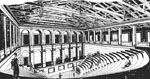
The imposing of the Roman rule in the region of Middle and Low Danube and the concomitant urbanization create the prerequisite condition for carriing out shows of Graeco-Roman type. Epigraphical data, jettons, theatrical masks and a bronze figurine reveal their popularity in the cities of the two provinces. However, just two such compounds are studied out.
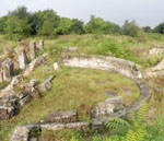
 1. A
theatre in Scupi (now Skopje, FYROM) in Moesia Superior
1. A
theatre in Scupi (now Skopje, FYROM) in Moesia Superior
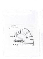
It is set near the village of Zlokuchene at 4 km from the capital city Skopje, which have very interesting cultural-historical sites. In situ are preserved substructions and architectural details from the theatre building. The design is of the Roman type theatre. Very rich architectural marble decoration is discovered. Built in the second quarter of the 2 century AD, it was able to seat more than 7000 people. The main cause for its destruction was an earthquake in the 518 AD.
 2. An
odeon in Nicopolis ad Istrum (near present village of Nikyup, Veliko Tarnovo region, Bulgaria) in Moesia Inferior.
2. An
odeon in Nicopolis ad Istrum (near present village of Nikyup, Veliko Tarnovo region, Bulgaria) in Moesia Inferior.
The odeon is a small theatre with
roof meant for musical performances. It is set just next to the city market
square in the West. The city is founded by emperor Trajan in the beginning
of the 2 century AD and until 193 AD administratively belongs to the province
of Thrace.
 The
odeon was built in the middle of the 2 century AD and was seated for near 400 people. The orchestra, part of the cavea and some shops looking at the surrounding streets are preserved. The central area of the Roman
city is exposed.
The
odeon was built in the middle of the 2 century AD and was seated for near 400 people. The orchestra, part of the cavea and some shops looking at the surrounding streets are preserved. The central area of the Roman
city is exposed.
The gladiators and bestiarii shows are among the most popular shows in the Roman Empire. Based on epigraphical and palaiographical data Moesia Superior and Moesia Inferior does not make an exception. However, only one amphitheatre is studied out.
 The
amphitheatre in Marcianopolis (now Devnya, Bulgaria) in Moesia Inferior.
The
amphitheatre in Marcianopolis (now Devnya, Bulgaria) in Moesia Inferior.
Marcianopolis is founded by emperor Trajan in honour of his sister Marciana. The city obtain great importance during 4 century AD, when it was promoted capital of the province of Moesia Inferior. The amphitheatre was built around 200 AD and was seated for 4000 people. The arena, parts of the cavea and some architectural decoration are preserved.
The Museum of the mosaics in modern Devnya offers magnificent examples of the late Roman and early Christian art of mosaics.
Lyudmil Vagalinski
Dimitrijević, D., Gabričević, D., Rnjak, D., Todorović, J. (eds.). Antički teatar na tlu Jugoslavije, Novi Sad, 1979.
Vagalinski, L. Sport and Gladiators in Ancient Thrace (Bulgaria), Sofia, 2005.
The Roman thermae are a phenomenal complex in technical, social, architectural and typological terms. By visiting the thermae daily, usually in the afternoon, after work and before dinner, or by spending their day there bathing, in entertainment, training practice, music, art, literary activities and others, the citizens participated actively and defined the social life of the settlements (cities) of the Roman Empire.
According to Krenker’s classification from 1929, in relation with his publication of the emperor thermae in Trir, the Roman thermae are divided into three types: linear (chain) type, circle type and emperor type. In the linear thermae the bathing people follow a successive route. In the circle type they go in circles in order to return to where they started. The emperor type is the type of the double ring (circle), ordered systematically around a common central space with common rooms, tepidarium, frigidarium and caldarium (axial type). The other type – semi-axial was defined by Krenker as a „semi-axial mixed type“. The round axial type (with an axis line which divides the bath complex in two symmetrical parts) is with an angle and parallel subtype, axial symmetrical or semi-symmetrical sub-type and finally, double axial symmetrical subtype. The classification is valid in the ordering of the rooms in connection with each other, namely from the vestibulum-dressing room, through the cold to the warm and hot rooms of the thermae (vestibulum, apoditerium, palaestra, frigidarium, tepidarium, caldarium, laconicum).
The bath structures in the provinces Moesia Inferior and Moesia Superior belong to two main categories – thermae and balneae. Often the literature does not discriminate between thermae and balneae buildings. The collective „thermae“ represents baths where the wealthy Roman citizens spend the day and their free time, engaged in discussion on politics, art, etc. Balneae for the ancient Greeks were buildings whose main purpose was to help build up the health of the citizens through various exercises and mineral water treatment.
In the architecture of the Roman provinces Moesia Inferior and Moesia Superior up to 212 several thermae buildings have been observed. Their construction began after the end of 1st c. AD – the beginning of 2nd c. and during their use each of them underwent several reconstructions. The remains of several civilian balneae constructions have been preserved.
Four thermae buildings are known from the province Moesia Inferior, the construction of which took place at the beginning of 2nd c. – in Istrus, the thermae in Varna (Odessus) and those in Silistra (Durostorum).
 In
the ancient Istria, (Republic of Romania), two thermae buildings have been
uncovered. Bathhouse No.1 belongs to the category of public bathhouses. It is of the circle type and an
area of 1 180 square metres. It was built in opus incertum and opus mixtum.
It is relatively well-preserved and it was later partially destroyed by the
city walls. It was built at the beginning of 2nd c., restored after the rule of Marc Aurelius. The city walls which partially
destroy it were built in the first half of 3rd c. In the 4th c. The bathhouse was used once more for a short period.
In
the ancient Istria, (Republic of Romania), two thermae buildings have been
uncovered. Bathhouse No.1 belongs to the category of public bathhouses. It is of the circle type and an
area of 1 180 square metres. It was built in opus incertum and opus mixtum.
It is relatively well-preserved and it was later partially destroyed by the
city walls. It was built at the beginning of 2nd c., restored after the rule of Marc Aurelius. The city walls which partially
destroy it were built in the first half of 3rd c. In the 4th c. The bathhouse was used once more for a short period.
 Bathhouse
No. 2 is of the category public thermae. Probably it was also of the circle
type. It has an area of 660 to 880 square metres. It was built in stone masonry
and mixed masonry. It was preserved to some extent but only the foundations
are visible now. It was mainly used in the second century and destroyed about
170 – 180, restored about 250.The thermae in Odessos (Varna, Republic of Bulgaria)
show us a bathhouse-gymnasium. They are monumental public thermae of the emperor
type, built on about 7 000 square metres in opus vittatum. They are well-preserved
and parts of them have still not been uncovered and studied. They were built
about 150 AD. The thermae have sections – for men and for women. This gives
the architectural plan a complete symmetry – separate halls situated on one
axis with a direction north – south and two monumental entrances on the north
side introducing the visitors into the rooms. In the apse part schola labri, which has not been uncovered yet, a laconicum with a hot water pool was probably situated. The thermae are marked by a rich
architectural decoration of imported sparkling white marble and a marble cover
on the floor in the so called opus alexandrinum. The walls were also covered
with thin marble plates. The thermae ceased to function at the end of 3rd – beginning of 4th c. After the architectural decoration was plundered, many small and bigger houses
were built on the terrain. After an earthquake in 544, as a result of big sea
waves rising, the roof construction of the thermae was destroyed, after which
their systematic destruction began.
Bathhouse
No. 2 is of the category public thermae. Probably it was also of the circle
type. It has an area of 660 to 880 square metres. It was built in stone masonry
and mixed masonry. It was preserved to some extent but only the foundations
are visible now. It was mainly used in the second century and destroyed about
170 – 180, restored about 250.The thermae in Odessos (Varna, Republic of Bulgaria)
show us a bathhouse-gymnasium. They are monumental public thermae of the emperor
type, built on about 7 000 square metres in opus vittatum. They are well-preserved
and parts of them have still not been uncovered and studied. They were built
about 150 AD. The thermae have sections – for men and for women. This gives
the architectural plan a complete symmetry – separate halls situated on one
axis with a direction north – south and two monumental entrances on the north
side introducing the visitors into the rooms. In the apse part schola labri, which has not been uncovered yet, a laconicum with a hot water pool was probably situated. The thermae are marked by a rich
architectural decoration of imported sparkling white marble and a marble cover
on the floor in the so called opus alexandrinum. The walls were also covered
with thin marble plates. The thermae ceased to function at the end of 3rd – beginning of 4th c. After the architectural decoration was plundered, many small and bigger houses
were built on the terrain. After an earthquake in 544, as a result of big sea
waves rising, the roof construction of the thermae was destroyed, after which
their systematic destruction began.
 One
of the most imposing buildings of the public architecture in Durostorum were
the thermae (Silistra, Republic of Bulgaria). They were built in the first
half of 2nd c. They are of the bathhouse type with a linear (chain) plan, facing southwest.
There are three warm rooms with three pools and a cold water pool. With time
the bathhouse underwent a number of reconstructions, new rooms were added,
canals and new floor levels were built. The last clearly expressed construction
period is from the first half of 4th c.
One
of the most imposing buildings of the public architecture in Durostorum were
the thermae (Silistra, Republic of Bulgaria). They were built in the first
half of 2nd c. They are of the bathhouse type with a linear (chain) plan, facing southwest.
There are three warm rooms with three pools and a cold water pool. With time
the bathhouse underwent a number of reconstructions, new rooms were added,
canals and new floor levels were built. The last clearly expressed construction
period is from the first half of 4th c.
 The
public thermae discovered in Moesia Inferior were built mainly after 3rd c. Most of them belong to the late antique age – Nicopolis as Istrum, Oescus,
Serdica, Pautalia. From the region of Scupi (modern-day Skopje, FYR Macedonia),
under the foundations of a basilica building, part of a bathhouse built in
opus incertum was discovered. An apsidal wall with a northwest-southeast orientation
has been discovered, with remains of a hypocaust system at the east side of
which the tepidarium was discovered and at the west – the prefurnium and caldarium,
and under the south aisle of the basilica a third thermae room is partially
uncovered, probably the apoditerium. The thermae, according to their researchers,
were built on a building from the early Roman times. In the early Christian
age a basilica was built on the thermae.
The
public thermae discovered in Moesia Inferior were built mainly after 3rd c. Most of them belong to the late antique age – Nicopolis as Istrum, Oescus,
Serdica, Pautalia. From the region of Scupi (modern-day Skopje, FYR Macedonia),
under the foundations of a basilica building, part of a bathhouse built in
opus incertum was discovered. An apsidal wall with a northwest-southeast orientation
has been discovered, with remains of a hypocaust system at the east side of
which the tepidarium was discovered and at the west – the prefurnium and caldarium,
and under the south aisle of the basilica a third thermae room is partially
uncovered, probably the apoditerium. The thermae, according to their researchers,
were built on a building from the early Roman times. In the early Christian
age a basilica was built on the thermae.
Svetla Petrova
Boetger, B. Die roemische Thermen in Varna, Altertum, 1977, 23, 29-36
Georgiev, P. Architectural and archaeological problems of the Roman thermae of Odessos. - In: Ancient Bulgaria. Papers Presented to the International Symposium on the Ancient History and Archaeology in Bulgaria, 1981, II. University of Nottingham, Nottingham, 1983,155-164.
Manderscheid, H. Bibliographie zum roemischen Badewesen unter besonderer Beruecksichtigung der oeffentlichen Thermen. Muenchen, 1988.
Mirchev, M. The Roman Thermae of Varna. (Russian with summary of English) – In: Actes du Premier Congres International des Etudes Balkaniques et Sud-est Europees. Sofia, 1969, 455-477.
Suceveanu, A. Histria, VI. Les Thermes romains. Bucarest, 1982.
Vacheva, K. Les Entrees dans les thermes romains d’Odessos (summary in French), Archeologija, 1986, 1, 1-8.
Donevski, P. - П. Доневски. Археологически разкопки на лагера и канабето на ХІ Клавдиев легион в Дуросторум. – В: Дуросторум, Дръстър, Силистра. Силистра 1988, 90.
Garashanin, M., Koracević, D. - М. Гарашанин, Д. Корачевич. Археоложки искупуваньа во Скупи од 1978 - 1981 година, Macedoniae Acta Archaeologica, 7-8, 1987, 79-92.