See this text in ![]()
Origin of the vici
Relation
to traffic routes
Function of the
places
Typical building
structures
Changes in
construction methods
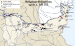
Religious cults
Summary
 In the first centuries AD the Latin term vicus
was probably used in Moesian provinces both for the co called semi-urban settlement
(without the status of a city but with significant population, well-developed
industrial and/or commercial activity and /or other specific functions) and
the small farming community (rural village, such as Fântânele). In the regions
away from the Danube, where Greek was more popular than Latin, the respective
term was usually kome. Very little archaeological research has been carried
out in the late Iron Age settlements in Serbia and in northern Bulgaria. The
scant information about local population settlements in the last centuries
BC
hinders defining precisely the changes or continuity of the settlement pattern
after the establishment of the Roman rule. We do not know either if such
pre-Roman
settlements as Troesmis and Aegyssus in Dobrogea, mentioned by Ovid for AD
12 and 15, and other unidentified settlements near residences of Getic rulers,
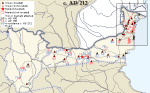
continued to prosper under the Romans. Many vici in existence in the Roman period
have been attested only by epigraphy (see
map) and about twenty only surveyed or sampled archaeologically, mostly
by rescue digs (see map). The only village
of the Roman period which has been excavated systematically to a large extent
is a possible vicus around the villa at Pavlikeni
podpis in northern Bulgaria.
In the first centuries AD the Latin term vicus
was probably used in Moesian provinces both for the co called semi-urban settlement
(without the status of a city but with significant population, well-developed
industrial and/or commercial activity and /or other specific functions) and
the small farming community (rural village, such as Fântânele). In the regions
away from the Danube, where Greek was more popular than Latin, the respective
term was usually kome. Very little archaeological research has been carried
out in the late Iron Age settlements in Serbia and in northern Bulgaria. The
scant information about local population settlements in the last centuries
BC
hinders defining precisely the changes or continuity of the settlement pattern
after the establishment of the Roman rule. We do not know either if such
pre-Roman
settlements as Troesmis and Aegyssus in Dobrogea, mentioned by Ovid for AD
12 and 15, and other unidentified settlements near residences of Getic rulers,
continued to prosper under the Romans. Many vici in existence in the Roman period
have been attested only by epigraphy (see
map) and about twenty only surveyed or sampled archaeologically, mostly
by rescue digs (see map). The only village
of the Roman period which has been excavated systematically to a large extent
is a possible vicus around the villa at Pavlikeni
podpis in northern Bulgaria.
 |
 |
 |
 More
than a dozen sites in Dardania (central and southern part of Upper Moesia) and
barely a few in Lower Moesia, e.g. Straja in Dobrogea and probably also Prisovo
in northern Bulgaria, however, have yielded modest evidence of opposite trends
operating in the province at the time: important changes in the native, pre-Roman
settlement pattern in the former case, and the survival of a certain number
of the original villages in their original locations in the latter. The komai
on the Black Sea coast, occupied mostly by hellenized Thracian or Getic rural
communities, also remained unaffected by the Romans. Some of the native hill-forts
(refugium-like settlements) in Dardania (e.g. Lopate near statio Lamud) and
possibly also in the tribal territories (cf.
map), such as that of Celtic Scordisci (e.g. Singidunum), were abandoned
following the Roman conquest. The resettled population took upresidence probably
in new villages situated in the valleys or plains where it was easier to control.
More
than a dozen sites in Dardania (central and southern part of Upper Moesia) and
barely a few in Lower Moesia, e.g. Straja in Dobrogea and probably also Prisovo
in northern Bulgaria, however, have yielded modest evidence of opposite trends
operating in the province at the time: important changes in the native, pre-Roman
settlement pattern in the former case, and the survival of a certain number
of the original villages in their original locations in the latter. The komai
on the Black Sea coast, occupied mostly by hellenized Thracian or Getic rural
communities, also remained unaffected by the Romans. Some of the native hill-forts
(refugium-like settlements) in Dardania (e.g. Lopate near statio Lamud) and
possibly also in the tribal territories (cf.
map), such as that of Celtic Scordisci (e.g. Singidunum), were abandoned
following the Roman conquest. The resettled population took upresidence probably
in new villages situated in the valleys or plains where it was easier to control.
 In Lower Moesia, the pre-Roman origin of at least some small rural communities
is indicated by the vici and komai bearing native, Thracian, Daco-Getic or
Celtic
names, attested epigraphically, however, not earlier than for the period of
integration in the 2nd to first half of the 3rd century AD. From the very beginning
of Roman military presence on the Lower Danube, extramural
settlements were established near military
sites: canabae around the legionary bases
as in Novae and vici next to auxiliary forts. Auxiliary townships, such
as Ravna (Timacum Minus), Sexaginta Prista
(Rousse), attested around AD 100, and the not much later Vicus Classicorum (Murighiol
in Dobrogea), attracted enterprising civilians, first from outside Moesia, then
also the natives, ready to provide for the soldiers’ needs. There is no information
on the evolution of auxiliary vici located on the Daco-Moesian provincial boundary
after the partial demilitarization of the Danube bank following the conquest
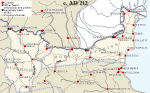
of Dacia (AD 106 - cf. map). Some of these
settlements certainly continued to exist, e.g. the semi-urban villages near
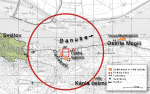
still operating auxiliary forts in the region of the Iron Gate in Karata? (Diana
Cataractarum), Donji Milanovac (Taliata) and Pontes opposite Drobeta (cf.
reconstruction). None of these vici has yet been excavated to such an extent
that we would be able to show its plan.
In Lower Moesia, the pre-Roman origin of at least some small rural communities
is indicated by the vici and komai bearing native, Thracian, Daco-Getic or
Celtic
names, attested epigraphically, however, not earlier than for the period of
integration in the 2nd to first half of the 3rd century AD. From the very beginning
of Roman military presence on the Lower Danube, extramural
settlements were established near military
sites: canabae around the legionary bases
as in Novae and vici next to auxiliary forts. Auxiliary townships, such
as Ravna (Timacum Minus), Sexaginta Prista
(Rousse), attested around AD 100, and the not much later Vicus Classicorum (Murighiol
in Dobrogea), attracted enterprising civilians, first from outside Moesia, then
also the natives, ready to provide for the soldiers’ needs. There is no information
on the evolution of auxiliary vici located on the Daco-Moesian provincial boundary
after the partial demilitarization of the Danube bank following the conquest
of Dacia (AD 106 - cf. map). Some of these
settlements certainly continued to exist, e.g. the semi-urban villages near
still operating auxiliary forts in the region of the Iron Gate in Karata? (Diana
Cataractarum), Donji Milanovac (Taliata) and Pontes opposite Drobeta (cf.
reconstruction). None of these vici has yet been excavated to such an extent
that we would be able to show its plan.
 |
 |
 |
A
substantial number of the rural communities in Dobrogea (cf.
map), particularly those bearing Roman names, like Ulmetum and vicus Novus,
and occupied in the 2nd century by veterans and other Roman citizens, as well
as the Lai and Bessi resettled from Thrace, must have been established by the
Romans within the framework of a considered colonizing operation, probably shortly
after the conquest of Dacia (AD 106). 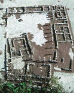 The
purpose of the colonization, as also of the earlier resettlement actions from
beyond the Danube, was undoubtedly to populate the hinterland of the limes and
provide a taxable source of income, and in the longer perspective, to create
a stable source of supplies and native recruits for troops stationing on the
Dobrogean section of the Danubian border, as well as an efficient maintenance
system for the newly-built road network. Finally,
there is an important group of rural villages in Dobrogea with toponyms formed
from personal names, e.g. vicus Quintionis. One is led to assume that these
settlements were established on private estates, taking their names after the
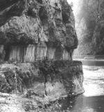
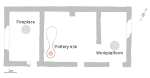
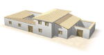
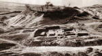
landowners. The 3rd century vicus at Pavlikeni in the territory of Nicopolis
ad Istrum owed its origin to a private villa (see
photo) with well developed, market oriented pottery production. There is
reason to suspect that some Moesian vici in existence in the Roman period and
depending upon their specialized functions as religious centres or spa-resorts
(e.g. Vrban and Vicus Casianum) originated from pre-Roman cult places stuated
sometimes near healing waters.
The
purpose of the colonization, as also of the earlier resettlement actions from
beyond the Danube, was undoubtedly to populate the hinterland of the limes and
provide a taxable source of income, and in the longer perspective, to create
a stable source of supplies and native recruits for troops stationing on the
Dobrogean section of the Danubian border, as well as an efficient maintenance
system for the newly-built road network. Finally,
there is an important group of rural villages in Dobrogea with toponyms formed
from personal names, e.g. vicus Quintionis. One is led to assume that these
settlements were established on private estates, taking their names after the
landowners. The 3rd century vicus at Pavlikeni in the territory of Nicopolis
ad Istrum owed its origin to a private villa (see
photo) with well developed, market oriented pottery production. There is
reason to suspect that some Moesian vici in existence in the Roman period and
depending upon their specialized functions as religious centres or spa-resorts
(e.g. Vrban and Vicus Casianum) originated from pre-Roman cult places stuated
sometimes near healing waters.
V. Dintchev (AIM-BAS), T. Sarnowski (IAUW)
V.H. Baumann, Aşezări rurale antice în zona gurilor Dunării. Contribuţii arheologice la cunoaştera habitatului rural (sec. I-IV p. Chr.), Tulcea 1995
V.H. Baumann, Noi săpături de salvare în aşezarea rurală antică de la Teliţa-Amza, jud. Tulcea, Peuce (NS) 1, 2003, 160 - 221
E. Čerškov, Rimljani na Kosovu i Metohiji, Beograd 1969
E. Condurachi, Beiträge zur Frage der ländlichen Bevölkerung in der römischen Dobrudscha, Corolla memoriae E. Swoboda dedicata, Graz-Köln, 95 -104
V.N. Dinčev, Polugradskite neukrepeni selišta prez rimskata, kâsnorimskata i rannovizantijskata epocha (I - načaloto na VII v.) v dnešnite bâlgarski zemi, Istorija 3-4, 1996, 99 -104
V.N. Dinčev, Selata v dnešnata bâlgarska teritorija prez rimskata epocha (I – kraja na III vek), Izvestija na Nacionalnija Istoričeski Muzej 11, 2000, 185 -218
S. Dušanić, Aspects of Roman Mining in Noricum, Pannonia, Dalmatia and Moesia Superior, Aufstieg und Niedergang der römischen Welt II 6, Berlin-New York 1977, 55 -94
B. Gerov, Zemevladenieto v Rimska Trakija i Mizija (I-III v.), Sofia 1980
Z. Gočeva, Der thrakische Festungsbau und sein Fortleben im spätantiken Fortifikationssystem in Thrakien, in: J. Hermann et al. (eds), Griechenland-Byzanz-Europa. Ein Studienband, Berlin 1988, 97-107
M. Irimia, Nouvelles données concernant les habitats gétiques en Dobroudja pendant la seconde époque du fer, Pontica 13, 1980, 100 -118
M. Mirković, Einheimische Bevölkerung und römische Städte in der Provinz Obermösien, Aufstieg und Niedergang der römischen Welt II 6, Berlin-New York 1977, 811 - 848
M. Mirković, Rimsko selo Bube kod Singidunuma, Starinar 39, 1988, 99 -104
A.G. Poulter, Rural Communities (Vici and komai) and Their Role in the Organization of the Limes of Moesia Inferior, in: Roman Frontier Studies 1979 (= British Archaeological Reports. Intern. Series 71 III), Oxford 1980, 729 -743
A.G. Poulter, Cataclysm on the Lower Danube: The Destruction of a Complex Roman Landscape, in: N. Christie (ed.), Landscapes of Change. Rural Evolutions in Late Antiquity and the Early Middle Ages, Aldorshot 2004
A. Suceveanu, Viaţa economică în Dobrogea romană secolele I - III e.n., Bucureşti 1977
A. Suceveanu, Fântânele. Contribuţii la studiul vieţii rurale în Dobrogea romană, Bucureşti 1998
A. Suceveanu, Al. Zahariade, Un nouveau vicus sur le territoire de la Dobroudja romaine, Dacia 30, 1986, 109-120
V. Velkov, Kâm vâprosa za agrarnite otnošenija v Mizija prez II v. na n.e., Archeologija 4, 1962, 31-35
V. Velkov, Die Stadt und das Dorf in Südosteuropa, Actes du IIe Congrès Intern. des Études du Sud-Est Européen, Athènes 1970, 147-166
V. Velkov, Dobrudža v perioda na rimskoto vladičestvo (I-III v.), in: A. Fol,
S. Dimitrov (eds), Istorija na Dobrudža, I, Sofia 1984, 124-155
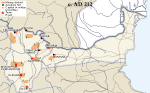
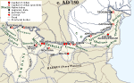
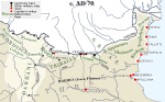
The growth and pattern of semi-urban and rural settlement in both Moesian provinces in the second century AD is clearly associated with the establishment of the Roman road network and the process of its extending. This concerns especially the Danubian Plain (Lower Moesia after AD 86), which was underpopulated in the first century. The creation of the first military lines of communication (viae militares) was accompanied, no later than in Nero’s reign (AD 54-68), by the establishment of numerous road and posting stations (mansiones) with all necessary buildings such as tabernae and praetoria mentioned in a contemporary inscription from Thrace.To believe later sources, such as the fourth-century Tabula Peutingeriana, there were as many as 10 posting stations operating on just one, hardly the longest road from Oescus to Philippopolis in Thrace. These stations (e.g. Storgosia, Melta, Sostra) have been located in the field and in the vicinity of each there is very fragmentary evidence of settlement; future research will presumably qualify this settlements as semi-urban villages (cf. map). On the important limes road along the Danube with its difficult section in the region of Iron Gate (Djerdap) the posting stations were probably located in the vici near still functioning or evacuated after the conquest of Dacia auxiliary forts.
 |
 |
 |
|
the
numerous rural villages in Dobrogea (cf. map)
owed their development largely to their location near the Roman roads, although
the situation had also its weaknesses. An inscription, now in the Museum of
Constan?, refers to some burdensome duties imposed on the inhabitants of Chora
Dagei and Laikos Pyrgos in connection with the villages’ location near a public
road (via publica). The duties, which were required of the inhabitants several
times in a year by the liturgiai and angareiai systems, were connected with
supplying the public post (cursus publicus). Abuses by the provincial administration
with regard to villages lying on the roads, and especially on the road crossings,
could have been prevented sometimes by the beneficiarii consularis, soldiers
detached from the legions for policing the roads. Their stations have been confirmed
epigraphically in some semi-urban (Sočanica - cf.
plan, Pavlikeni - cf. plan, Storgosia)
as well as rural villages (Râmnicu de Jos - Vicus V... and Mihai Bravu - Vicus
Bad...).
 |
|
E. Čerškov, Rimljani na Kosovu i Metohiji, Beograd 1969
V.N. Dinčev, Polugradskite neukrepeni selišta prez rimskata, kâsnorimskata i rannovizantijskata epocha (I - načaloto na VII v.) v dnešnite bâlgarski zemi, Istorija 3-4, 1996, 99-104
V.N. Dinčev, Selata v dnešnata bâlgarska teritorija prez rimskata epocha (I – kraja na III vek), Izvestija na Nacionalnija Istoričeski Muzej 11, 2000, 185 -218
K. Dočev, Stari rimski pâtišta v Centralna Dolna Mizija (II-IV v. sl. Chr.), Sbornik Rjahovec. Veliko Târnovo-G. Orjahovica 1994, 61 -76
B. Gerov, Zemevladenieto v Rimska Trakija i Mizija (I - III v.), Sofia 1980
M. Madžarov, Rimskijat pât Eskus-Filipopol. Pâtni stancii i selišta, Plovdiv 2004
M. Mirković, Einheimische Bevölkerung und römische Städte in der Provinz Obermösien, Aufstieg und Niedergang der römischen Welt II 6, Berlin-New York 1977, 811-848
M. Mirković, Vom obermösischen Limes nach dem Süden: Via Nova von Viminacium nach Dardanien, in: Roman Frontier Studies 1979 (= British Archaeological Reports. Intern. Series 71 III), Oxford 1980, 745-755
A.G. Poulter, Rural Communities (Vici and komai) and Their Role in the Organization of the Limes of Moesia Inferior, in: Roman Frontier Studies 1979 (= British Archaeological Reports. Intern. Series 71 III), Oxford 1980, 729 -743
A. Suceveanu, Viaţa economică în Dobrogea romană secolele I-III e.n., Bucureşti 1977
Y. Todorov, Le grandi strade romane in Bulgaria, Roma 1937
S. Torbatov, The Roman Road Durostorum – Marcianopolis, Archaeologia Bulgarica 4, 2000, 59-72
M. Vasić, G. Milošević, Mansio Idimum. Roman Post Station near Medveđa, Belgrade 2000
V. Velkov, Dobrudža v perioda na rimskoto vladičestvo (I-III v.), in: A. Fol, S. Dimitrov (eds), Istorija na Dobrudža, I, Sofia 1984, 124-155
|
|
|
Considering that few Moesian vici have so far been "sampled" either
by field walking or rescue digs (cf.
map), and none has yet been excavated in full (cf. Pavlikeni as one possible
exception - see plan), we are forced to
draw conclusions on their function and role in the life of the province mainly
on the grounds of analyses of the following data: location and geographical
distribution - see map; social,
ethnic and professional make-up of the population ; practiced religious
cults; toponymy; evidence of various agricultural and industrial activities;
finds of tools and the presence of structures of special purpose.
Most Moesian vici were relatively small
rural communities, which regardless of origin were usually dependent on the agricultural
exploitation of their territories (terrae vici). They usually operated a mixed
agricultural and pastoral economy (e.g. Fântânele in Dobrogea - cf.
plan). While in the fertile farming lowlands defining for the economy of
villages was grain production, in the semi-mountainous and mountainous regions
cattle breeding played a very significant role. Other agricultural activities,
such as cultivation of vines and fruit trees or growing vegetables have left
less archaeological traces. Traditional occupations of farming, often enough
with grain cultivation on a medium scale, are signaled not only by finds of
agricultural implements; some villages had small substantial granaries (Mihai
Bravu, Kurt Baiîr), others have yielded
religious dedications to "agricultural" deities (Silvanus Sator,
Ceres, Liber Pater), and the gravestone of
one of the inhabitants of Vicus Ulmetum in Dobrogea depicts the ploughing
of fields and the tending of a flock of sheep.
|
 |
 |
Fântânele in Dobrogea |
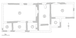
Kurt Baiîr | Gravestone Ulmetum in Dobrogea |
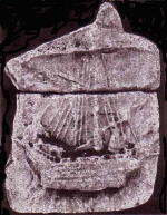 The inhabitants of at least some of the vici on the Danube
or Black Sea coast understandably must have been involved in fishing, shipping
and commerce; testifying to this, for example, are the name of a settlement
in
Dobrogea (Vicus Classicorum - cf. photo),
a ship representation from Vicus Celeris
and the presence of a sailing corporation (nautae universi Danuvii) in another
village (Axiopolis). The Histrian custom documents allow to assume that the
villagers
at the mouth of the Danube were deriving some income from production and trading
salted fish and wood, probably with neighbouring villages and through Histria
also with more distant cities on the Black Sea littoral. Meaningful in this
respect are also two religious dedications from a vicus near Durostorum: one
was to Mercury,
the Roman deity of trade, and the other to the Winds (Flattoribus Ventis) and
the Good Gust of Wind (Bono Flanti). It is likely that some of these unexcavated
villages were semi-urban in character and occasionally fully deserved to be
styled as small towns or townships.
The inhabitants of at least some of the vici on the Danube
or Black Sea coast understandably must have been involved in fishing, shipping
and commerce; testifying to this, for example, are the name of a settlement
in
Dobrogea (Vicus Classicorum - cf. photo),
a ship representation from Vicus Celeris
and the presence of a sailing corporation (nautae universi Danuvii) in another
village (Axiopolis). The Histrian custom documents allow to assume that the
villagers
at the mouth of the Danube were deriving some income from production and trading
salted fish and wood, probably with neighbouring villages and through Histria
also with more distant cities on the Black Sea littoral. Meaningful in this
respect are also two religious dedications from a vicus near Durostorum: one
was to Mercury,
the Roman deity of trade, and the other to the Winds (Flattoribus Ventis) and
the Good Gust of Wind (Bono Flanti). It is likely that some of these unexcavated
villages were semi-urban in character and occasionally fully deserved to be
styled as small towns or townships.
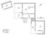
The inhabitants of a few rural villages (e.g. Kamen - see
plan), Credin?, Niculi?l, Vicus Ulmetum, Gura Canliei) engaged in industrial
activity, usually conducted on a small scale, course pottery and sun-dried bricks
production, ore smelting, iron, copper and bone working, blacksmithing; weaving
was also an important domestic industry. An additional source of income was probably
for the villagers from some Moesian rural vici work at burning limestone and in
stonepits situated in the countryside near such settlements as for instance Hotnica
in the territory of Nicopolis ad Istrum, ?rnavoda, Dobromir and Dervent in Dobrogea.
A very important group of Moesian settlements was composed
of the vici situated in the Upper Moesian mining districts - see
map (e.g. vici metalli at Socanica, Jezero, Stojnik) and the vici functioning
in Lower Moesia as production and/or market centres (e.g. Butovo-Emporium Piretensium,
Pavlikeni, Hotnica). The latter ones, lying in the territory of Nicopolis ad Istrum,
played an important role as places for large local and regional pottery industry,
including fine, high quality table ware. The pottery industry at Pavlikeni, dependent
first (2nd century AD) upon a private villa (see
photo) and then (3rd century AD) upon a later vicus (see
plan) was operated not only by the inhabitants, but presumably also by slaves.
 |
 |
|
|
Kamen |
Pavlikeni private villa |
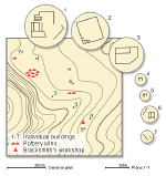
The vessels produced in Butovo are to be found not only on civilian and military sites in Lower Moesia but also in Lower Dacia and in the Crimea beyond the frontiers of the Roman Empire. To judge by the better investigated examples, such as Socanica in Dardania (cf. plan) and Pavlikeni in Lower Moesia (see plan), most vici which can be qualified as mining, industry or market settlements had a physical appearance of semi-urban settlements with workshops, pottery kilns, buildings accommodating the workers or for the storage of goods for sale and a variety of additional amenities, such as e.g. basilical halls and other public buildings. With due caution the same can be said probably about the vici by road stations (e.g. Storgosia, Graničak) even if at the moment no plans of such settlements from the period of Principate are available. The Serbian archaeologists suppose that at Metvedja on the road Viminacium – Horreum Margi (cf. map) a vicus with shops, inns and private workshops servicing the travellors existed already before the erection of the well studied buildings of the official posting station (Mansio Idimum), dated to the 4th century AD. In keeping with a practice known from other provinces, not only the inhabitants of the rural vici but also the occupants of the semi-urban settlements by road stations had to fill duties connected with road maintenance and the operation of the public post (cursus publicus). Epigraphic documentation of this phenomenon in the mid second century AD in Lower Moesia refers to the Dobrogean villages of Chora Dagei and Laikos Pyrgos.
|
|
 |
Very little can be said about the Moesian vici situated near hot-water springs, sometimes developed into spa-resorts (e.g. Vrban in Dardania) and about the settlements near native religious sites (e.g. Vicus Casianum in Dobrogea). The vicus Storgosia formed near the official station on the road Oescus – Philippopolis performed its function probably also as the religious centre of the territorium Dianensium. Because of unsufficient state of archaeological research (no plans available) we can only guess that like in other frontier provinces of the Roman Empire these settlements that derived considerable income from healing properties of the springs or as regional centres of pilgrimage showed the characteristics that distinguished them from usual rural vici; it has been suggested that they sometimes merited the description of "small towns" or "townships".
|
|
 |
While
discussing the function of the Moesian vici one has to take into account
an important role played especially in the period of occupation
and early in the period of integration by the extramural vici near existing
or
evacuated auxiliary forts (ex. Timacum Minus - cf. map,
Taliata, Sexaginta Prista) or vici situated about 2 km = 1 leuga (cf.
plan) from legionary fortresses (ex. Ostrite
Mogili municipalized as Municipium Novensium; Ostrov municipalized as Municipium
Aurelium Durostorum). Their location with regard to military sites determined
their primary function, e.g. commerce, industry, services, crafts. An incomplete
state of current archaeological research (no stratified plans available)
does
not allow to distinguish the early phases of settlements from the later
ones after the garrison’s departure, as occurred in some of the Upper Moesian
and western
Lower Moesian auxiliary forts or after the grant of municipal autonomy
for
the vici at Ostrite Mogili and Ostrov. Starting from the second half of
the first
century AD, some of the vici existing near former (possibly Pincum and
Tricornium) or still functioning forts (cf. map) occupied
by auxiliary troops (Dimum ?, Timacum Minus ?), likely took
over the function of centres (capita civitatium - see
map) of civilian territorial organization as tribal
capitals.
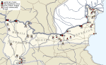
The geographical distribution of rural vici attested epigraphically,
demonstrating a concentration in Dobrogea, suggests that contrary to the
other parts of the two Moesian provinces (see map),
which presumably enjoyed a greater share of big land estates left in state,
imperial
and private hands (e.g. between Ratiaria and Oescus and to the east of
Yantra river), the Dobrogean rural villages played an important role both
in providing
the Greek towns on the Black Sea coast with agricultural products and in
the system
of supplying the troops stationed along the Lower Danubian limes.
|
|
 |
|
| Vici near forts | Timacum Minus | Capita civitatium | Rural vici |
E. Čerškov, Rimljani na Kosovu i Metohiji, Beograd 1969
E. Condurachi, Beiträge zur Frage der ländlichen Bevölkerung in der römischen Dobrudscha, Corolla memoriae E. Swoboda dedicata, Graz-Köln, 95 -104
V.N. Dinčev, Polugradskite neukrepeni selišta prez rimskata, kâsnorimskata i rannovizantijskata epocha (I- načaloto na VII v.) v dnešnite bâlgarski zemi, Istorija 3-4, 1996, 99 -104
V.N. Dinčev, Selata v dnešnata bâlgarska teritorija prez rimskata epocha (I – kraja na III vek), Izvestija na Nacionalnija Istoričeski Muzej 11, 2000, 185 - 218
S. Dušanić, Aspects of Roman Mining in Noricum, Pannonia, Dalmatia and Moesia Superior, Aufstieg und Niedergang der römischen Welt II 6, Berlin-New York 1977, 55 - 94
B. Gerov, Zemevladenieto v Rimska Trakija i Mizija (I-III v.), Sofia 1980
M. Madžarov, Rimskijat pât Eskus-Filipopol. Pâtni stancii i selišta, Plovdiv 2004
M. Mirković, Einheimische Bevölkerung und römische Städte in der Provinz Obermösien, Aufstieg und Niedergang der römischen Welt II 6, Berlin-New York 1977, 811 - 848
A.G. Poulter, Rural Communities (Vici and komai) and Their Role in the Organization of the Limes of Moesia Inferior, Roman Frontier Studies 1979 (= British Archaeological Reports. Intern. Series 71 III), Oxford 1980, 729 -743
A.G. Poulter, Cataclysm on the Lower Danube: The Destruction of a Complex Roman Landscape, in: N. Christie (ed.), Landscapes of Change. Rural Evolutions in Late Antiquity and the Early Middle Ages, Aldorshot 2004
A. Suceveanu, Viaţa economică în Dobrogea romană secolele I-III e.n., Bucureşti 1977
A. Suceveanu, Fântânele. Contribuţii la studiul vieţii rurale în Dobrogea romană Bucureşti 1998
M. Vasić, G. Milošević, Mansio Idimum. Roman Post Station near Medveđa, Belgrade 2000
V. Velkov, Die Stadt und das Dorf in Südosteuropa, Actes du IIe Congrès Intern. des Études du Sud-Est Européen, Athènes 1970, 147-166
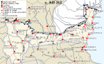
Our knowledge of typical building structures from vici (cf.
map) of different origins and function in Upper and Lower Moesia is largely
imperfect and it can hardly be otherwise considering how relatively few regular
excavations (cf. map) have been carried
out. Indeed, most of the work has been of a salvage nature.
To judge by extensive spread of surface pottery and building
debris some of the Moesian semi-urban settlements covered an area of over 10
ha. The rural villages were not much smaller; in the full extent they could
have measured often about or even over 10 ha. In the fertile agricultural regions,
such as for instance in the hinterland of the limes (cf.
map) to the south of Novae and east of the Yantra river the latest archaeological
survey shows a relatively dense settlement system; rural villages and villas
were spaced there from 2 to 5 km from each other.
|
|
 |
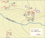
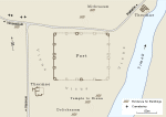
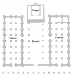
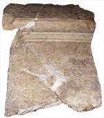
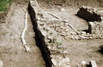
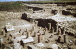
With the exception of the semi-urban vicus at Socanica (cf. plan) in Dardania with regular spacing of streets and buildings the current state of research of the Moesian vici does not show any sign of planning in the layout of streets. In the auxiliary vicus at Ravna-Timacum Minus where such amenities as bath buildings were shared between fort and settlement private dwellings and other buildings encircled the fort on three sides. The location of cemetery at some distance from the fort seems to suggest that it was planned like in in Britain or German provinces far enough to create necessary space for the construction of the vicus. If our reconstruction of the layout of streets in Ostrite Mogili (see plan) is right, it probably appeared only in the later period when in the late 2nd or early 3rd century AD the vicus received municipal status.
|
|
| Socanica | Ostrite Mogili |
The only investigated to some extent rural vici in the Moesian
provinces (Fântânele and Kamen) show two different layout patterns: roadside
villages (Fântânele with farmsteads situated along both sides of a small river
- see plan) and settlements with widely spaced courtyard
farmhouses of peasant renters situated among parcels of arable land (Kamen -
see plan). Drawing an analogy from the
adjacent territories of the Roman province Thracia it can be speculated that
the unifying components of such vici were their common tumulus cemeteries and,
possibly, isolated sanctuaries. The sanctuaries,
when there were any (ex. Vicus Casianum), were on the periphery of the villages
or at a certain distance from them. Such seem to be the vicus-sites at Goljama
Brestnica (Longinopara ?), Prisovo, Gorsko Ablanovo, Niculi?l, Teli?-Amza, Sarichioi
and Sveti Nikola (no plans available).
|
|
|
| Fântânele | Kamen |
Valuable information about various buildings in the
Moesian vici has been provided by finds of inscribed stones. Public buildings
erected in the settlements were mentioned in a few Latin and Greek
building
inscriptions, originating from the Lower and Upper Moesian vici. Temples
of Jupiter Best and Greatest, Jupiter and Hercules, Jupiter Dolichenus,
Diana,
Mars, Antinous, Terra Mater, Mithras are attested epigraphically by building
inscriptions from semi-urban villages at Ravna (Timacum Minus), Socanica,
Lopate,
Guberevac, Sopot and Rudnik in Upper Moesia, and from rural or possible
rural settlements at Bjala Slatina, Dragoevo, Ko?ov, Valea Teilor
and Urluia
in Lower Moesia. One of the temples attested epigraphically (see
map) was excavated (the temple to Antinous
at Socanica). The presence of a temple or chapel at a given location could
be deduced occasionally from a concentration of religious
dedications devoted to a single deity found at one site (ex. dedications
to oriental deities Mithras and Jupiter Dolichenus in Ravna – Timacum
Minus) or the mention in an inscription of a religious association (e.g.
in Vicus Clementianensis,
Vicus Ulmetum, Neat?nea and in Butovo).
 |
|
 |
| Villages
with public buildings attested epigraphically |
|||
| Semi-urban
villages in mining districts |
Semi-urban
villages by road stations |
Rural villages | Possible rural villages |
| TEMPLES | |||
| Guberevac Sočanica Sopot Rudnik |
Lopate Kuršumlijska Banja |
Gromšin Valea Teilor Urluia |
Bjala
Slatina Dragoevo Košov |
| BATHS | |||
| Vicus
Petra |
Rousse Karataš |
||
| OTHER BUILDINGS | |||
| Caranasuf (Abitorion), Vicus Quintionis (Auditorium) |
|||
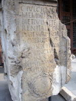
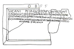
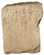
There is epigraphical confirmation of three public structures in three of the rural vici from the territory of modern-day Dobrogea: an auditorium or assembly hall in the vicus Quintionis in the countryside (chora) of Histria, which served the needs of not only the elected officials (magistri vici), but probably also other representatives of the inhabitants (veterani et cives Romani et Bessi consistentes) of a settlement clearly boasting quasi- or premunicipal organization; a balineum or bath in the vicus Petra (see inscription) in central northern Dobrogea, erected by the vicani Petrenses "for the health of the body" (causa salutis corporis); an abitorion at Caranasuf near Histria, a structure of unknown function, believed by some to be an outdoor toilet facility. According to an inscription from Sinoe-Casapchioi (vicus Quintionis), the auditorium there was rebuilt in the reign of Antoninus Pius (AD 138-161), which could mean that it had been in operation at an earlier date already.
|
 |
 |
| Dobrogea |
None of the buildings mentioned in the
second and third century inscriptions from Dobrogea has been excavated
so far. We are entitled to assume,
however,
that the village assembly halls, wherever they actually existed, could
not have been much different from Building D in the Romano-Getic settlement
of Teli?-Amza in northern Dobrogea. This structure, which covered an
area
of over 130 m2, consisted of two small rooms located symmetrically on
either side of the entrance, and a big rectangular room in the back
(7.15 by 9.70
m), divided symmetrically into three aisles by two rows of three supports
(columns ?). The discoverers presumed the existence of columns in the
entrance,
which measured 3.20 m in width. The pavement in this building was of
stone.
 As in other frontier provinces in Europe, so on the Lower
Danube, baths (thermae) in semi-urban vici lying near the auxiliary forts
were what one might call a canonical building structure. Inscriptions
found
at Rousse in Bulgaria and at Karata? in Serbia speak of such
buildings in Sexaginta Prista and Diana Cataractarum. Two bath-houses
were excavated in Ravna (Timacum Minus - cf. plan)
and one in Donji Milanovac (Taliata). There is no way to estimate, however,
to what
extent also the rural landscape of Moesian vici was dotted with similar
public baths, such as already mentioned balineum in vicus Petra. Perhaps
clay water-pipe systems, such as those
found at Pavlikeni, also supplied modest village balinea with water.
As in other frontier provinces in Europe, so on the Lower
Danube, baths (thermae) in semi-urban vici lying near the auxiliary forts
were what one might call a canonical building structure. Inscriptions
found
at Rousse in Bulgaria and at Karata? in Serbia speak of such
buildings in Sexaginta Prista and Diana Cataractarum. Two bath-houses
were excavated in Ravna (Timacum Minus - cf. plan)
and one in Donji Milanovac (Taliata). There is no way to estimate, however,
to what
extent also the rural landscape of Moesian vici was dotted with similar
public baths, such as already mentioned balineum in vicus Petra. Perhaps
clay water-pipe systems, such as those
found at Pavlikeni, also supplied modest village balinea with water.
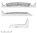
The presently known homesteads from the Moesian rural
villages can be divided into a number of types. The most modest of the
huts are similar to the late Iron Age Grubenh?ser (sunken-floored huts).
These
single-room, usually oval, but occasionally rectangular and trapezoidal
habitations found in a few Dobrogean vici, had a surface area ranging
from
9 to 20 m2.
In the first and early second century AD settlement at Teli?-Amza, the
huts formed small groups of two or three, set some 50 m apart as a rule
(no general
plan available). They were sunk a few dozen centimeters into the ground.
A massive post in the center suggests a conical roof supported on low
walls;
without a central post, the hut appeared more like an ordinary shelter.
Interior furnishings (features and installations) included storage pits,
earth platforms (for sleeping ?) and fireplaces. The latter were occasionally
built outside the huts.
 Considering mentions of Troglodytae (Troglodytai),
whom Strabo, Pliny and Ptolemy all reported among the peoples inhabiting
eastern Moesia (cf. map)
in the first century AD, one is led to believe, based also on the etymology
of the name, that at least some of the local population lived seasonally
in caves. This is an archaeologically confirmed fact for the pre-Roman
period.
It is possible, however, that the name referred to people who were still
actually living in huts sunk in the loess at the beginning of the Roman
period.
Considering mentions of Troglodytae (Troglodytai),
whom Strabo, Pliny and Ptolemy all reported among the peoples inhabiting
eastern Moesia (cf. map)
in the first century AD, one is led to believe, based also on the etymology
of the name, that at least some of the local population lived seasonally
in caves. This is an archaeologically confirmed fact for the pre-Roman
period.
It is possible, however, that the name referred to people who were still
actually living in huts sunk in the loess at the beginning of the Roman
period.
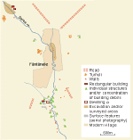
In the second and third century AD, the inhabitants of
rural settlements in Dobrogea and on the Danubian Plain generally lived
in farmhouses. The evolution of this form is well exemplified by investigations
carried out in the settlement of Fântânele(see map)
situated in the countryside of the Greek colony of Histria.
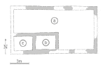
 Prior
to being destroyed at the end of the second century AD, Dwelling α
(see plan)
was a rectangular building, consisting of a courtyard (a) and two small
rooms (b, c). The courtyard could have been taken up in part by a roofed
portico supported on stone columns; eight small limestone column bases
were
found, unfortunately not in situ, along with two shaft fragments and
one capital. A structure found near the southeastern corner, of which
merely
two short sections of walls survive, must have served as a sort of outbuilding.
The alleged presence of a portico in the farmhouse of the first phase
(c.
AD 150) suggested to the discoverer the potential influence of Hellenistic
domestic architecture. In phase II (see
plan), the building developed into a block measuring 30 by 11.75 m.
It then incorporated four clearly distinct parts: a residential quarter
supplemented by a large cooking area and dining room (g), and a domestic
part consisting primarily of a semi-open stockyard (h) and small storeroom
? (i).
Prior
to being destroyed at the end of the second century AD, Dwelling α
(see plan)
was a rectangular building, consisting of a courtyard (a) and two small
rooms (b, c). The courtyard could have been taken up in part by a roofed
portico supported on stone columns; eight small limestone column bases
were
found, unfortunately not in situ, along with two shaft fragments and
one capital. A structure found near the southeastern corner, of which
merely
two short sections of walls survive, must have served as a sort of outbuilding.
The alleged presence of a portico in the farmhouse of the first phase
(c.
AD 150) suggested to the discoverer the potential influence of Hellenistic
domestic architecture. In phase II (see
plan), the building developed into a block measuring 30 by 11.75 m.
It then incorporated four clearly distinct parts: a residential quarter
supplemented by a large cooking area and dining room (g), and a domestic
part consisting primarily of a semi-open stockyard (h) and small storeroom
? (i).
At
approximately the same time, the closely set buildings of a settlement discovered
in Kurt Baiîr near the modern
locality of Slava Cercheză in central northern Dobrogea were block-like
(or single-body)
rectangular structures (see
plan),
measuring respectively 85 and 147 m2 in area. Living and domestic
quarters, ranging in number from one to three, in the back part of
the complex,
were
preceded by a kind of long gallery in front. A grand entrance with
two columns was featured in one of the buildings. With time, a small
room
(e) was built,
joining the two structures into one complex, which by then also included
a separate outbuilding in the form of a rectangular stone-paved granary.
In
the Danubian Plain, a plan similar to the one described above was
demonstrated by some homesteads in the settlement that
arose around the villa in Pavlikeni (see
plan),
which specialized in ceramic vessel production. The same plan was
also to
be discerned in the remains explored in the settlement at Kamen (see
plan), this and the previous site being both situated in the rural hinterland
of Nicopolis ad Istrum.
|
|
|
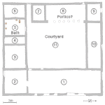 |
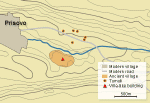
| Pavlikeni | Kamen | Prisovo |
Most of the buildings combining living and
domestic functions in one enclosure, which are known from present-day
northern Bulgaria, resemble the villa-farms with big open courtyards
surrounded by
rows of rectangular rooms developing one after the other. A typical
example is a building from Prisovo (see plan),
a settlement located south of Nicopolis ad Istrum. The structure
(see
plan) occupied an area of 22.5 by 24 m and incorporated a courtyard
with alleged portico on the northern side, storeroom (4) and what
were evidently living quarters (2, 3, 6), as well as domestic units
(1, 7,
9, 10); it also
contained a heated room (corn dryer ?) featuring a hypocaust system
(5). A similar installation was also found at the biggest villa-like
building
discovered at V?bovska Reka in Pavlikeni.
In the semi-urban settlement at Stojnik in the mining district of
Kosmaj in Upper Moesia some of the houses were also equipped with
hypocaust
heeting and decorated with frescos (no plans available).
L. Kovalevska, T. Sarnowski (IAUW), V. Dintchev (IAM-BAS)
V.H. Baumann, Aşezări rurale antice în zona gurilor Dunării. Contribuţii arheologice la cunoaştera habitatului rural (sec. I-IV p. Chr.), Tulcea 1995
V.H. Baumann, Noi săpături de salvare în aşezarea rurală antică de la Teliţa-Amza, jud. Tulcea, Peuce 1 (14), 2003, 155 - 181
I. Cârov, Edin rimski vikus kraj selo Kamen, Izvestija na Istoričeski Muzej – V. Târnovo 12, 1997, 124 -133
E. Čerškov, Rimljani na Kosovu i Metohiji, Beograd 1969
E. Čerškov, Municipium DD kod Sočanice, Beograd 1970
S. Conrad, D. Stančev, Archaeological Survey on the Lower Danube between Novae and Sexaginta Prista, in: Limes XVIII (= British Archaeological Reports. Intern. Series 1084 II), Oxford 2002, 673-684
V.N. Dinčev, Selata v dnešnata bâlgarska teritorija prez rimskata epocha (I – kraja na III vek), Izvestija na Nacionalnija Istoričeski Muzej 11, 2000, 185 - 218
A. i C. Opaiţ, T. Bănică, Das ländliche Territorium der Stadt Ibida (2.-7. Jh.) und einige Betrachtungen zum Leben auf dem Land an der unteren Donau, Die Schwarzmeerküste in der Spätantike und im frühen Mittelalter, Wien 1992, 103 -112
P. Petrović, Inscriptions de la Mésie Supérieure. III 2. Timacum Minus et la Vallée du Timok, Beograd 1995
A.G. Poulter, Cataclysm on the Lower Danube: The Destruction of a Complex Roman Landscape, in: N. Christie (ed.), Landscapes of Change. Rural Evolutions in Late Antiquity and the Early Middle Ages, Aldorshot 2004
A. Suceveanu, Fântânele. Contribuţii la studiul vieţii rurale în Dobrogea romană Bucureşti 1998
B. Sultov, Edna villa rustica kraj s. Prisovo V. Târnovski
okrâg, Izvestija na Okrâžnija Muzej V. Târnovo, 2, 1964, 49-64
The only 1st and early 2nd century AD building structures from the Moesian
vici, of which we have knowledge that is more substantial, are the huts
with sunken floors (Grubenh?ser) in the settlement at Teli?-Amza in
Dobrogea. Made of impermanent materials, namely wood, branches and clay,
they were constructed in a manner that did not differ substantially
from
the later Iron Age habitations of the population living both to the north
and south of the lower course of Danube. The huts were of two kinds:
with
a central post and without, but in all cases the floors were sunken up
to a few dozen centimeters below ground level. The post was made of
a tree
trunk, while smaller stakes around the circumference formed the framework
for the wattle-and-daub walls. Stake-holes in huts without walls testify
to a conical roof construction made of thatch, reed and branches, and sealed
with daub. A similar roof but supported on a central post
covered huts with low walls.
|
|
|
|
| Fântânele | Prisovo | Kamen | Pavlikeni |
In the second and early third centuries AD, the sites
of Teli?-Amza and Prisovo (which had probably started out in the later Iron
Age as native hamlet-like settlements with modest huts) developed into well-organized
villages with at least a few romanized farmhouses each. The settlements
at Fântânele (see plan), Prisovo (see
plan)and Kamen (see plan) must
have become vici of this sort, too, around AD 200. Their appearance must
have been very much like that of second-century settlements, which grew
on villa estates, as in Pavlikeni (see
plan), for example. One of the characteristic elements of changing construction
was, among others, the increasingly frequent use of stone in the pavements
of some buildings and outbuildings, as well as in wall foundations. Another
newly introduced element were bricks and roof tiles fired in relatively
high temperatures, used alongside mud brick. Thus, stone appears as
a building material even in the principally wooden sunken-floored huts of
the first and early second century. At Sarichioi in northeastern Dobrogea,
the roof supports in the entrances to the sunken-floored huts were made
of stone.
 In the end of the second and in the early third century,
and in Dobrogea even around the middle of the second century, the farmhouse-like
homesteads (cf. reconstruction)
in the Moesian rural vici were erected on stone foundations, typically raised
some 20 to 30 cm above ground level and forming a kind of base straight
on the ground. Broken sandstone, limestone and argillaceous slate from local
outcrops was almost invariably earth-bonded. Possibly under the influence
of villa architecture, which had already become heavily romanized at an
earlier date, in some of the vici the bearing walls of the bigger homesteads
(perhaps high-status dwellings) had stone foundations sunk up to 50 cm into
the ground (e.g. Prisovo - see plan
and reconstruction). The use of lime mortar was noted in a few cases,
as well as the presence of small quantities of lime in the bonding material
(vicus Petra in Dobrogea, Kamen and Prisovo on the Danubian Plain); these
were prepared according to requirements, as evidenced by a square pit containing
more than 4 m3 of lime, discovered 9 m from the farmhouse in Prisovo .
The
thickness of bearing walls was 0.50-0.65 m and 0.80 m (exceptionally in
Kamen), while partition walls were about 0.45 m thick. Low foundations
or substructures supported walls erected of either mud brick or wattle-and-daub,
or tamped loess or clay in boarding formwork. The substructure of one of
the partition walls in Prisovo included rectangular kiln-baked bricks with
holes a few centimeters deep used to mount the vertical elements of a wooden
wall framework. Walls constructed in this manner were capable of supporting
not only a mud-coated roof of thatch, straw or branches, but also the much
heavier roofs made of fired tiles.
In the end of the second and in the early third century,
and in Dobrogea even around the middle of the second century, the farmhouse-like
homesteads (cf. reconstruction)
in the Moesian rural vici were erected on stone foundations, typically raised
some 20 to 30 cm above ground level and forming a kind of base straight
on the ground. Broken sandstone, limestone and argillaceous slate from local
outcrops was almost invariably earth-bonded. Possibly under the influence
of villa architecture, which had already become heavily romanized at an
earlier date, in some of the vici the bearing walls of the bigger homesteads
(perhaps high-status dwellings) had stone foundations sunk up to 50 cm into
the ground (e.g. Prisovo - see plan
and reconstruction). The use of lime mortar was noted in a few cases,
as well as the presence of small quantities of lime in the bonding material
(vicus Petra in Dobrogea, Kamen and Prisovo on the Danubian Plain); these
were prepared according to requirements, as evidenced by a square pit containing
more than 4 m3 of lime, discovered 9 m from the farmhouse in Prisovo .
The
thickness of bearing walls was 0.50-0.65 m and 0.80 m (exceptionally in
Kamen), while partition walls were about 0.45 m thick. Low foundations
or substructures supported walls erected of either mud brick or wattle-and-daub,
or tamped loess or clay in boarding formwork. The substructure of one of
the partition walls in Prisovo included rectangular kiln-baked bricks with
holes a few centimeters deep used to mount the vertical elements of a wooden
wall framework. Walls constructed in this manner were capable of supporting
not only a mud-coated roof of thatch, straw or branches, but also the much
heavier roofs made of fired tiles.
The roofing-tiles in use, usually c. 2.5 cm thick, included the flat type
with flanges (tegulae cum marginibus) as well as a gently arched so-called
Laconian type. The width of these roof tiles ranged from 27 to 39 cm, the
length from 43 to 69 cm. The usually semi cylindrical cover-tiles (imbrices
or calypteroi, to use a Greek term), which usually joined the tiles at the
top, were of appropriate length. The diameter of these tiles was from 12
to 18 cm. The technological revolution that occurred under Roman influence
– also impacted by the Greeks in the coastal areas - was reflected in the
common use of wrought iron nails, from 6.5 to 18 cm long, in the wooden
structure of the roof.
 Kiln-baked bricks of square and rectangular shape were
also used for the hypocaust heating (Prisovo, Pavlikeni),
in the body of a furnace (?) for heating purposes (Fântânele) and in a pavement
(Kamen). Their length did not exceed 34 and the width 17 cm, while the thickness
usually oscillated around 4 cm. Bricks did not follow strictly the Roman
standards of size based on the foot = 0.296 m and referred more frequently
to the Greek linear standards. Bricks used for the pillars (pilae) supporting
the suspensura, i.e. the floor suspended above the hypocaust, in Prisovo
were up to 8 cm thick. At Pavlikeni warm air circulated in the hypocaust
cellar between vertical water-pipes which successfully replaced brick pillars
under the floor.
Kiln-baked bricks of square and rectangular shape were
also used for the hypocaust heating (Prisovo, Pavlikeni),
in the body of a furnace (?) for heating purposes (Fântânele) and in a pavement
(Kamen). Their length did not exceed 34 and the width 17 cm, while the thickness
usually oscillated around 4 cm. Bricks did not follow strictly the Roman
standards of size based on the foot = 0.296 m and referred more frequently
to the Greek linear standards. Bricks used for the pillars (pilae) supporting
the suspensura, i.e. the floor suspended above the hypocaust, in Prisovo
were up to 8 cm thick. At Pavlikeni warm air circulated in the hypocaust
cellar between vertical water-pipes which successfully replaced brick pillars
under the floor.
Room 5 in the villa-like building at Prisovo also
had heated walls. The heated inner face of the wall made of ceramic tiles
was separated from the stone outer walls by ceramic bobbins attached using
T-shaped elements.
At a few Dobrogean vicus-sites (T?gusor, vicus near Capidava
and Rasova-La Pesc?ie), situated relatively near the limes on the Danube
(cf. map), and at Butovo on the Danubian
Plain, as well as in the municipalized vicus at Ostrite Mogili (Municipium
Novensium - cf. plan), the bricks and
roofing-tiles found there bear the stamps of Moesian legions and auxiliary
troops
This could possibly correspond to the presence in many vici of discharged
soldiers, a fact evidenced in inscriptions and by finds of military
diplomas (Fântânele, Mihai Bravu, Teli?-Amza, Butovo).
Around AD 200, some of the inhabitants of the Moesian
rural vici lived in houses of relatively high standard, often resembling
villas, which they doubtless wished to emulate. Testifying to this are
fragments
of painted plaster from Prisovo, marble elements of interior decoration
from Izvorul Mare and Capul Tuzla, stone bases and column shafts from
Fântânele,
Kurt Baiîr near Slava Cercheză Ivrinezu Mic, and the window glass from
Fântânele. In some of the vici, masonry wells and water-source facilities
were supplemented
with local water-supply systems making use of terracotta pipes.
L. Kovalevska, T. Sarnowski (IAUW)
M. Bărbulescu, Viaţa rurală în Dobrogea romană (sec. I-III p. Chr.), Constanţa 2001
V.H. Baumann, Aşezări rurale antice în zona gurilor Dunării. Contribuţii arheologice la cunoaştera habitatului rural (sec. I-IV p. Chr.), Tulcea 1995
V.H. Baumann, Noi săpături de salvare în aşezarea rurală antică de la Teliţa-Amza, jud. Tulcea, Peuce 1 (14), 2003, 155 - 181
I. Cârov, Edin rimski vikus kraj selo Kamen, Izvestija na Istoričeski Muzej – V. Târnovo 12, 1997, 124 -133
V.N. Dinčev, Selata v dnešnata bâlgarska teritorija prez rimskata epocha (I – kraja na III vek), Izvestija na Nacionalnija Istoričeski Muzej 11, 2000, 185 - 218
A. i C. Opaiţ, T. Bănică, Das ländliche Territorium der Stadt Ibida (2.-7. Jh.) und einige Betrachtungen zum Leben auf dem Land an der unteren Donau, Die Schwarzmeerküste in der Spätantike und im frühen Mittelalter, Wien 1992, 103 -112
A. Suceveanu, Fântânele. Contribuţii la studiul vieţii rurale în Dobrogea romană Bucureşti 1998
B. Sultov, Edna villa rustica kraj s. Prisovo V. Târnovski okrâg, Izvestija na Okrâžnija Muzej V. Târnovo, 2, 1964, 49 - 64
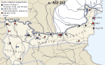
The vicus is best evidenced for Moesia Inferior
(see map) and within its boundaries
for Dobrogea; it even determines a certain specificity of the province.
Testimony from Upper Moesia is sporadic, although there is no way of knowing
how little or many of the sources have survived. Therefore, the below reflections
on the religious cults of vicus inhabitants are largely relevant to Lower
Moesia.
Surviving religious dedications are mostly of official
character. Those erecting them were either vicus officials
(mostly magistri), or else specific groups
of inhabitants (all of the residents?) of a given vicus upon the initiative
of their officials. This state of affairs was reflected in the designations
cives Romani consistentes (settlers with Roman citizenship - cf.
photo), veterani et cives Romani consistentes (military settlers and
settlers with Roman citizenship), and veterani et cives Romani et Lai and/or
Bessi consistentes (military settlers and settlers with Roman citizenship
and the Lai and/or Bessi), vicani (vicus inhabitants) or Viconovenses (inhabitants
of Vicus Novus). Even so, there is no lack of inscriptions whose founders
were private individuals, acting upon their own initiative
|
|
| officials | Settlers with Roman citizenship |
.
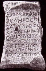
 Heading the ranking of worshipped deities is Jupiter
(Juppiter Optimus Maximus - cf.
photo). As a phenomenon, it is only natural, considering the "official"
character of the inscriptions. Jupiter symbolized the Roman state and religious
manifestations of homage to him were an expression of state loyalty. At
the same time, they may have been deemed a way of emphasizing the legal
and political status of the migrant population versus the autochthons. Juno
(Iuno Regina) also occurs in the inscriptions next to Jupiter, although
surprisingly seldom (four dedications from vicus Ulmetum, three from vicus
Secundini, one each from vicus Celeris, Turris Mucaporis, vicus Tautiomosis).
Not once is there any mention of Minerva, the third of the Capitoline divinities.
Perhaps the distinct emphasis on the Jupiter cult reflected a religious
veneration of the ruler, whose identification with Jupiter hardly needed
special justification. It should be made clear that a substantial part of
the surviving inscriptions were dedicated to Jupiter (and possibly to Juno)
"for the health" (pro salute) of the reigning emperor (two dedications from
vicus Trullensium, one each from vicus Ulmetum, vicus Quintionis, vicus
Secundini).
Heading the ranking of worshipped deities is Jupiter
(Juppiter Optimus Maximus - cf.
photo). As a phenomenon, it is only natural, considering the "official"
character of the inscriptions. Jupiter symbolized the Roman state and religious
manifestations of homage to him were an expression of state loyalty. At
the same time, they may have been deemed a way of emphasizing the legal
and political status of the migrant population versus the autochthons. Juno
(Iuno Regina) also occurs in the inscriptions next to Jupiter, although
surprisingly seldom (four dedications from vicus Ulmetum, three from vicus
Secundini, one each from vicus Celeris, Turris Mucaporis, vicus Tautiomosis).
Not once is there any mention of Minerva, the third of the Capitoline divinities.
Perhaps the distinct emphasis on the Jupiter cult reflected a religious
veneration of the ruler, whose identification with Jupiter hardly needed
special justification. It should be made clear that a substantial part of
the surviving inscriptions were dedicated to Jupiter (and possibly to Juno)
"for the health" (pro salute) of the reigning emperor (two dedications from
vicus Trullensium, one each from vicus Ulmetum, vicus Quintionis, vicus
Secundini).
Jupiter occurred also in association with other deities.
In vicus Quintionis he was identified with the Dolichenian Baal as Iuppiter
Dolichenus. At Vicus Ulmetum he was accompanied by Silvanus, who appears
to have enjoyed special popularity there. Also at Ulmetum Jupiter was worshipped
together with Hercules. At Giridava a votum was dedicated to Jupiter the
Best and Greatest and to all other gods and goddesses. From Topalu in Dobrogea,
where an ancient vicus of unidentified name was localized, there comes a
dedication to Jupiter associated with Juno and Ceres Frugifera. The same
goddess (Ceres Frugifera) was mentioned in an inscription from Tropaeum
Traiani along with Jupiter, Hercules Invictus and Liber Pater.
Deities occurring "independently",
that is, not in connection with Jupiter or Juno are very rare.
The worship of Liber (Liber Pater), an agricultural deity, identified with
Dionysus (Bacchus) is hardly surprising. From Troesmis comes an altar dedicated
to Jupiter and Liber Pater (Dionysus); similarly from Tropaeum Traiani,
there is one inscription mentioning Liber Pater next to Jupiter associated
with Hercules and 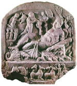 Ceres, and another one in which he is mentioned alone.
Naturally, dedications to Ceres (Ceres Frugifera) should also be linked
with the Liber Pater milieu. Undoubtedly close was the worship of Silvanus,
patron of the forests, but also of fields and pastures. Evidenced in Vicus
Ulmetum is an association (cultores) of the worshippers of this god with
the attribute "Sower" (Sator) and Sanctus. Further, a collegium Silvani
operated at Neat?nea in central Dobrogea. Evidence of a worship of this
deity was also recorded at Vicus Quintionis, where he appeared together
with the Nymphs.
Ceres, and another one in which he is mentioned alone.
Naturally, dedications to Ceres (Ceres Frugifera) should also be linked
with the Liber Pater milieu. Undoubtedly close was the worship of Silvanus,
patron of the forests, but also of fields and pastures. Evidenced in Vicus
Ulmetum is an association (cultores) of the worshippers of this god with
the attribute "Sower" (Sator) and Sanctus. Further, a collegium Silvani
operated at Neat?nea in central Dobrogea. Evidence of a worship of this
deity was also recorded at Vicus Quintionis, where he appeared together
with the Nymphs.
Hercules (cf.
photo) is frequently seen in Jupiter’s company (Tropaeum Traiani, Vicus
Ulmetum), but there is no dearth of dedications referring to him alone (Vicus
Quintionis, ?endreni). A vicus from the vicinity of Durostorum yielded an
inscription in homage of Mercury with the attribute Sanctus. A unique altar
found there was dedicated to the Auspicious Winds and the Good Gust of Wind.
In one case, we also find Mithra, mentioned as Deus Bonus Mithra, and similarly
Diana as Diana Optima.
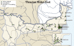
Deities of Thracian origin, like the Thracian Rider-God, Sabasios or Megas
Theos are evidenced mostly by representations on votive tablets from numerous
vicus-sites in Dobrogea, northern Bulgaria, but also in Serbia (cf.
map). Only twice is there epigraphical evidence in the vici recorded
in inscriptions (cf. map) of the cult
of the Thracian Heros. The first is an inscription from Vicus Trullensium,
the second is from Vicus Ulmetum. In a Thracian rural sanctuary in V. T?novo-D?ga
L?a (cf. plan, reconstruction
and photo), south of Nicopolis ad
Istrum, there was found recently, however, a marble votive tablet showing
the Thracian horseman and bearing a Greek dedication to Heros. It says that
the votum was dedicated by the village (kome) with Thracian name Theolopara.
The population of Thracian origin, like the Bessi and
Lai in the Dobrogean vici Ulmetum, Secundini and Quintionis, for example,
was probably striving simultaneously for full assimilation (at least
in
official religious manifestations) in order to identify with broadly understood
Romanity. An excellent example of such an attitude is provided by the
votive
altars from vicus Quintionis, erected by the inhabitants regularly during
celebrations of the Italic feast of the Rosalia on June 13.
 |
|
 |
 |
 |
L. Mrozewicz, T. Sarnowski (IAUW)
M. Bărbulescu, Viaţa rurală în Dobrogea romană (sec. I-III p. Chr.), Constanţa 2001
I. Cârov, Niakoi aspekti na kulta kâm Trakijskija Konnik v regio Nicopolitana, Izvestija na Istoričeski Muzej – V. Târnovo 14, 1999, 78 - 87
B. Gerov, Zemevladenieto v Rimska Trakija i Mizija (I-III v.), Sofia 1980
E. Čerškov, Municipium DD kod Sočanice, Beograd 1970
T. Gerasimov, Edin chram na Trakijskija bog-konnik pri s. Lesičeri, Târnovsko, Studia in honorem K. Škorpil, Sofia 1961, 245 - 253
Z. Gočeva, M. Oppermann, Corpus Cultus Equitis Thracii, II1, II2, Leiden 1981, 1984
N. Hampartumian, Corpus Cultus Equitis Thracii, IV, Leiden 1979
G. Kacarov, Thrake (Religion), Real-Encyclopädie der classischen Altertumswissenschaft, VI A, Stuttgart 1936, 472 - 551
G. Kacarov, Die Denkmäler des Trakischen Reitergottes in Bulgarien (Dissertationes Pannonicae II 14), Budapest 1938
K. Konstantinov, Trakijsko svetilište pri s. Draganovec, Târgoviško. Trakijski svetilišta. Trakijski pametnici (Monumenta Thraciae antiquae), II, Sofia 1980
M. Munteanu, Les divinités du panteon gréco-romain dans les villages de la Dobroudja romaine, Pontica 6, 1973, 73-86
D. Ovčarov, Trako-rimsko selište i svetilište na Apolon pri s. Gorno Ablanovo, Târgiviško, Archeologija 14, 1972, 46 - 55
P. Petrović, Inscriptions de la Mésie Supérieure. III 2. Timacum Minus et la Vallée du Timok, Beograd 1995
A. Suceveanu, Fântânele. Contribuţii la studiul vieţii rurale în Dobrogea romană Bucureşti 1998
A. Suceveanu, Al. Zahariade, Un nouveau vicus sur le territoire de la Dobroudja romaine, Dacia 30, 1986, 109 - 120
J. Todorov, Paganizmât v Dolna Mizija (prez pârvite tri veka sled Christa), Sofia 1928
 Despite its fragmentariness, the
panorama of Moesian townships and villages, which emerges from an analysis
of available evidence, seems familiar enough. It also illustrates perfectly
well the Roman Empire’s role in the cultural
Despite its fragmentariness, the
panorama of Moesian townships and villages, which emerges from an analysis
of available evidence, seems familiar enough. It also illustrates perfectly
well the Roman Empire’s role in the cultural
development of the eastern and central European provinces. For a variety
of reasons, the urbanization of the North Balkans (cf.
map) with its distinctly pastoral model of economy before the arrival
of the Romans was much more limited than in neighbouring Pannonia or Noricum
(modern Hungary and Austria), for example; civilizational and cultural advancement
in vast areas of modern Serbia, Bulgaria and Romanian Dobrogea in the first
centuries AD was dependent primarily on the introduction and promotion of
new forms of rural settlement in these regions. An extremely important role
in this process, clearly stimulated by the Roman provincial administration,
was played by the rural, as well as semi-urban
vici.
They changed the landscape and the economic status of a significant
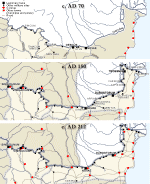
part of the Moesian provinces. It turned out that even after the Romans
had settled, in the first century AD, large tribal groups (cf. Native
tribes, Moesia c. 70, Tribal
capitals c. 150) of barbarians from beyond the Empire’s borders on the
Lower Danube, these vast lands were still capable of accepting many new
settlers, for example, from the overpopulated coasts of Asia Minor, creating
for them an attractive perspective of profitable economic enterprises and
practically universal development. All benefited from this situation,
including
the state, because with suitable taxing the population of the province
ensured not only economic self-sufficiency, but also the security of supplies
for
the thousands of Roman soldiers stationed on the limes.
|
|
|
| Native tribes | Moesia c. 70 | Tribal capitals c. 150 |
In the geographic and climatic conditions of Moesia,
at least some of the vici and komai offered apparently an attractive alternative
to urban life. The demography of many
townships and villages stands in proof, the local population being composed
of not only Thracians resettled from the south of modern Bulgaria already
in the first years of Roman presence on the Lower Danube and Getae of local
origin as well as resettled from beyond the Danube in the first century
AD. Also making up the population of these settlements were numerous veterans
and civilians coming in mostly from the Greek-speaking lands of the Empire.
Just as the cultural status of the western provinces was shaped foremost
by the cities with their essential rural territories full of villas and
vici, so on the Lower Danube the small rural vici and komai (cf.
map), much more distant from the cities and legionary bases than, for
instance, in the German provinces or in Britain, played a much more important
role. In the bilingual or trilingual (Greek, Latin and Geto -Thracian) quasi-municipal
local communities, ethnic differences were gradually eradicated. With the
coming of a new mentality and a largely new world outlook and system of
values, this process led to the formation of a common, Roman-provincial
culture. For veterans and other newcomers from culturally more advanced
areas of the Empire settling in the Moesian villages, the vici were
primarily a place where they could put into life their family plans or get
wealthy. For the native residents (cf. Native
tribes, Moesia c. 70, Tribal
capitals c. 150), the vici became a place for education, in languages,
economy and technical know-how, as well as in self-government and the organization
of a varied social, cultural and religiouslife. The specificity of these
local communities within the greater cultural community of the northern
provinces of the Roman Empire depended on the considerable input of the
Greek-speaking element and a considerable variety of forms of social life.
T. Sarnowski (IAUW)