See this text in ![]()
Over the past decades the most considerable advance in the field of Roman research
north of the Middle Danube has been marking of the locations of numerous marching
or temporary camps. It turns out that these relatively simple earthworks have
been the most impressive evidence of the Roman military occupation over the
territory mentioned above. The first discoveries were made in the region of
Lower Austria where some Roman camps of different sizes and types have been
identified by aerial reconnaissance during the 1980s. In the years to follow
numerous aerial surveys over South Slovakia and South Moravia have brought further
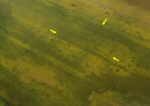
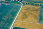
examples of crop marks amounting to almost 30. Due to the experience with the
aerial reconnaissance also some features discovered during usual field research
could be defined as marching camps. Yet more than twenty years after the first
discoveries some of the earlier results have gradually undergone a re-evaluation.
First of all it becomes clear that not all crop marks ascertained by observation
from the air and formerly considered to be the posts of the Roman troops may
be plausibly classified as camps. The thing is that the origin and the dating
of a number of them seem to be uncertain. A gradual verification by field research
and further aerial survey enables their distinguishing into several groups with
a differing level of conclusiveness. The following could be considered as the
convincing proofs of the Roman provenance of these objects and their dating
to the years of the Marcomannic wars: 1. stratigraphic situation at the places
of the finds, 2. artefactual evidence, 3. often also their shape and structure
defined by the typical rounded corners, gate types and perimeter defences.
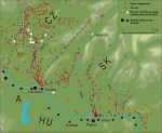
Despite a certain reduction by the not very reliable examples the number of the hitherto known sites still remains sufficient enough to recognise two main zones of distribution of the marching or temporary camps: one in the area north of Carnuntum and Vindobona stretching as far as to the territory of Moravia (Czech Republic), and the other in Southwest Slovakia, mainly in the belt on the left bank of the Danube. Although in respect of the assumed further advance of the Roman troops northward other sites in the northerly part of Western Slovakia, where the presence of the Roman unit has been documented by the well-known inscription as far as on the rock of the Trenčín Castle (Laugaritio), are not out of the question, the hitherto plausible crop marks, e.g. the objects in Šurany or Velký Kýr have recently been thrown into doubt as structures of Roman origin.
 |
 |
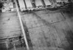
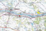
If we observe the distribution of the hitherto known camps in the zone north of Vindobona and Carnuntum, the most southern and the largest of them was recorded by aerial photography in Engelhardsstetten located near the crossing of the Danube. It has a rectangular shape with rounded corners; the length of the best preserved side of this single-ditched rectangular enclosure was about 700 m, so the camp could have stretched on an area of no less than 40 ha. Another large camp was located in Kollnbrunn on the old road from Vienna northward. The sides of the rectangular work measuring 395x590 m enclose an area of about 24 ha. The camp in Bernhardsthal, situated on the right bank of the River Thaya near its confluence with the Morava River, is documented as angles with short lengths of the adjacent sides. The dating to the years of the Marcomannic wars has been established by means of stratigraphy. The remains of the ditched marching camp overlay Germanic homesteads that have been deserted - after the dating of Samian ware (early Rheinzabern) - some time in the 120s, while the same Roman earthwork was superposed by later Germanic structures dated to the 3rd century.
 |
 |
 |
 Further
earthworks at Suchohrad and Závod are situated on the left bank of the Morava
River. A V-shaped ditch of the rectangle-arranged marching camp in Závod has
overlaid the relics of an older Germanic settlement from the 2nd
century and has been disturbed by a younger object from the 3rd century at one
spot. This supports the dating of the earthwork to the time of the Marcomannic
wars again.
Further
earthworks at Suchohrad and Závod are situated on the left bank of the Morava
River. A V-shaped ditch of the rectangle-arranged marching camp in Závod has
overlaid the relics of an older Germanic settlement from the 2nd
century and has been disturbed by a younger object from the 3rd century at one
spot. This supports the dating of the earthwork to the time of the Marcomannic
wars again.
The discoveries of marching camps and other earth-works in the territory of
Moravia came as a surprise. Due to their distance from the Danube these represent
the northernmost evidence of the Roman presence in the whole region beyond the
Norican and Pannonian frontier.
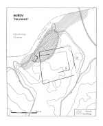
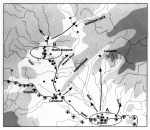
One of the greatest marching camp concentrations was indicated ca 2.4 km south-east
of the Roman fort at Mušov-Burgstall. It is situated on the right bank of the
River Thaya on a low terrace in the location „V pískách”, where aerial reconnaissance
by a survey team has discovered four Roman military sites. The course of their
defences consisting of V-shaped ditches cannot always be precisely captured
by photographs. The largest of the camps, reaching the area of as much as 38
ha, had a trapezoid shape, the individual sides measuring 670, 560, 630 and
620 m respectively. The ditch was 300 cm wide and up to 220 cm deep.
Within
the area of this site and in its surroundings it was possible to distinguish
the traces of further works in the form of lines and stripes in the crop marks
that could be considered the remnants of another similar fortification. According
to preliminary measurements the dimensions of one of them may cover an area
of about 20-21 ha. The smallest of the group of the marching camps in this
location was originally of square shape, its area being 1.5 ha, the length
of the sides
totalling to 120 m. The trenches have revealed a V-shaped ditch, 310 cm wide
and 200 cm deep. The last of the Mušov earthworks in the close eastern neighbourhood
of the largest camp has not been studied or measured yet.
 |
 |
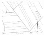
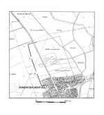
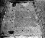
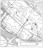
The earthwork near Charvatská Nová Ves ca 20 km to the south-east of the Roman fortress at Mušov-Burgstall belongs to the especially typical forms of Roman temporary or marching camps. The lengths of the sides of this extensive camp of a roughly rectangular shape were 450 and 550 m, so the area of the camp was approximately 21 ha. There were two gateways also protected with traverse (tutuli) on the well distinguishable south-eastern front.
 |
 |
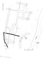
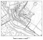
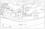
Especially in the surroundings of the Roman hillfort at Burgstall-Mušov an amount of further earthworks which are of a military character have been identified by aerial research. First of all we have to mention the outline of a long ditch in less than 1 km distance to the west from the earth ramparts of the Burgstall hillfort. It stretched in the southwest-northeast direction over more than 2 km. Although its full routing has not been corroborated, we may assume that the ditch ended somewhere near a marching or temporary camp in Ivaň, and that its original length was slightly over 4 km. The V-shaped ditch was 4.4 m wide and 1.98 m deep, and a gate with a „titulum” was a proof of its Roman origin. All evidence suggest that the ditch was enclosing the entire area - measuring almost 9 square kilometres - outlined by the confluences of the Thaya and Svratka, and the Jihlavka and Svratka Rivers. Access routes to this area were guarded by a temporary camp concentration in the location „Mušov - V pískách” on the southern side, and by the temporary camps at Ivaň on the northern side. The crop marks repeatedly captured by aerial photographs of the north-west foreground of Burgstall indicate that other temporary camps securing an access from the west were probably located here. As shown by the discoveries to follow, the further military installations were located on the main route running from the Roman enclave at Mušov to the north.
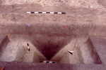
Two camps have been identified from the air near the village of Ivaň, about 2.7 km northwardly from the Roman fort at Mušov, on the left bank of the River Jihlavka. Only one of them has been tested by digging. Unfortunately, the greater part of it lies in the area now buried beneath the village development, so that only the north-eastern side of the camp has been preserved. Its area may be approximately estimated at 7.5 ha. The excavations in 1992 have revealed a V-shaped ditch, 1.26 m deep and 1.78 m wide, and the eastern gateway with a traverse 10.4 m wide. The unearthed rectangular traces of postholes are evidently related to gate structures defending the entrance. In addition to these the trenches have confirmed the eastern side of the camp.
 |
 |
 |
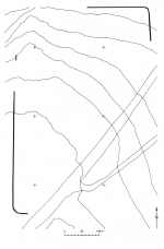
A remarkable marching camp concentration was discovered northwest
of the village of Přibice, about 8 km north of Burgstall and 6 km of the site
in Ivaň, on a terrace on the left bank of a dead arm of the River Jihlavka,
which has formerly constituted the main stream. Altogether three marching camps
have so far been discovered there, of square to trapezoid shapes. The V-shaped
ditch of the first large camp, having an area of 28 ha with the lengths of the
sides 530, 460, 480 and 750 m respectively, measures 220 cm across, and was
only 116 cm deep with a cleaning-channel at the base. The north-western part
of the sides respects by its bent course a smaller camp which, according to
preliminary measurement, can be averaged only at about 1 ha. Digging has uncovered
the south-western gate, 5 m wide, and a part of a V-shaped ditch, 242 cm wide
and up to 176 cm deep.
During further aerial surveys in 1993 another marching
camp No III with the biggest dimensions out of the entire group has been discovered
in the south-east direction from this site. The crop marks have enabled the
distinguishing of three of its fronts the lengths of which were 700, 550 and
350 m respectively. Using the aerial photographs gateways with traverse (tutuli)
have been identified with both of the large camps No I and III.
 |
 |
 |
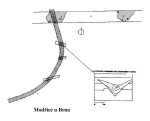 Another
marching camp in the north direction was unearthed by digging in Modřice near
Brno. Two ramparts of the camp formed by a typical V-shaped ditch with rounded
corner have cut the Germanic settlement from the 2nd century and
could be dated to the time of the Marcomannic wars as well. The earthworks
in Poštorná, Valtice and one in the vicinity of the village of Šakvice have
been recognised as Roman camps through their shape
defined by the characteristic rounded corners and perimeter defences.
Another
marching camp in the north direction was unearthed by digging in Modřice near
Brno. Two ramparts of the camp formed by a typical V-shaped ditch with rounded
corner have cut the Germanic settlement from the 2nd century and
could be dated to the time of the Marcomannic wars as well. The earthworks
in Poštorná, Valtice and one in the vicinity of the village of Šakvice have
been recognised as Roman camps through their shape
defined by the characteristic rounded corners and perimeter defences.
The latest archaeological discoveries which have located new
enclosures in the surroundings of Brno led to the conclusion that the advance
of Roman troops could have run further to the north-east, into the interior
of the German territory. Recent archaeological excavations and aerial surveying
have indeed shown further locations in north Moravia: three temporary camps
situated in the foreland of the so called Moravian Gate (Olomouc-Neředín, Hulín-Pravčice,
Osek) have been partly corroborated, the former two by digging, the latter one
by cropmarks.
Most of the marching or temporary camps are sited in strategic places, often
by the river crossings. The deployment of some of them on the left northern
banks of the rivers, as is the case in Ivaň, Přibice and Šakvice, confirms the
observation from Britain that whenever a river had to be crossed in the course
of the northward advance, a military unit has bivouacked on the far side. However
there are some exceptions, like the marching camp concentration at Mušov-Písky,
guarding the river crossing from the south.
Clusters of military installations on a relatively small area, embracing two
to four sites, may be explained in several ways. It may be assumed that several
camps, averaging 20-40 ha in area, were planned to house a full legion, exceptionally
two legions (Engelhardstetten), or a legion and vexillations. The combination
of large camps with small sites of 1-2 ha, as was the case at Mušov „V Pískách”
or in Přibice, can be understood, if they are contemporaneous, as the garrisoning
of a legion supplemented by an auxiliary unit. On the other hand, the concentration
of a number of these sites in outstanding places allows for an explanation that
such aggregations represent a successive use and reuse of the area over several
times and probably during many campaigns.
The evidence of the relatively numerous camps constructed in
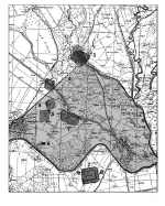
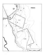
the area of South-western Slovakia now come up for discussion. The temporary
camps located in the vicinity of an earth-timber fort in Iža, South-western
Slovakia, were of outstanding importance. At this site at least five ditched
bivouacs of the Roman army were identified by aerial survey. They were of rectangular
or trapezoidal shapes and were located close to one another.
Their sizes were
different, the areas varying from 1 ha to 6.5 ha. Short discontinuities of
the ditch on all four sides suggested gateways. The V-shaped ditch was only
2-2.5
m wide and approximately 2 m deep. The filling of one of the ditches has contained
a denarius of Emperor Commodus stamped for his consort Crispina between the
years 178-180. The coin provides a base for the dating of the entire agglomeration
of camps: according to their spatial arrangement the camps were contemporaneous
and dated back to the last stage of the Marcomannic wars. At a mere 7 km distance
to the east, in Virt and Radvaň upon the Danube, much bigger camps have been
discovered
by aerial reconnaissance at a later date. These were advantageously situated
on
a high terrace over the former outfall of the Žitava River into the Danube.
Opposite to these camps, in the western direction, was the Roman fort of Odiavum
located on the Pannonian bank of the Danube. During the aerial reconnaissance
only a part of the ditch with a rounded corner has outlined from the camp
in
Virt. However the geophysical survey succeeded in tracing up the entire northern
front of the camp in the length of 830 m stretching up to the north-western
corner of the camp. The line of the rampart was broken at two spots at the
approximate distance of 280 m from the corner by gateways protected by tutuli.
The camp was located at the edge of the terrace and its shorter sides might
have measured around 600 m. Its total area is estimated at approximately 50
ha.
 |
 |
Out of the camp in Radvaň (camp No 2) only a part of its eastern front with a rounded corner at the length of ca 340 m has been captured, as well as a part of the northern front as a slightly broken line at the length of ca 440 m. The rest of the camp is either located in the municipal lands, or has been destroyed by gravel mining. The dimensions of the earth work could have been 400x500m, so the area of the camp might have amounted to as many as 20 ha. The ditches of both camps have been verified by excavations. With the Virt camp the ditches were as deep as 2.8 m and 4.5 m wide. Along their inner side there was a foundation trench for the supporting structure of the rampart mound. The ditch of the camp in Radvaň was ca 1.6 m wide and 1.3 m deep.
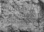
 It
is important for the dating of the camp in Virt that a sestercius of Marcus
Aurelius from 168-169 has been discovered near its eastern front by means of
a metal detector. Dating of both camps into the years of the Marcomannic wars
is also supported by six cremation burials of Roman soldiers unearthed in 1960
within a rescue dig in Radvaň upon the Danube roughly 30 m off the camp in Radvaň
and 800 m off the camp in Virt. The inventories of the graves, the Roman artefacts
and the Marc Aurelius coin from between 162 and 165 allow for a judgement that
the dead were most probably buried at the time of the Marcomannic wars.
It
is important for the dating of the camp in Virt that a sestercius of Marcus
Aurelius from 168-169 has been discovered near its eastern front by means of
a metal detector. Dating of both camps into the years of the Marcomannic wars
is also supported by six cremation burials of Roman soldiers unearthed in 1960
within a rescue dig in Radvaň upon the Danube roughly 30 m off the camp in Radvaň
and 800 m off the camp in Virt. The inventories of the graves, the Roman artefacts
and the Marc Aurelius coin from between 162 and 165 allow for a judgement that
the dead were most probably buried at the time of the Marcomannic wars.
Because the areas of both camps were partly overlapping, it is assumed that
the camps have been constructed in the course of two military expeditions.
An
extensive object in Virt with the possibility of bivouacking for at least two
legions or more vexillations with auxiliary forces could have been established
by the Romans at their mighty punitive expeditions against the Quads as early
as during the first stages of the Marcomannic wars; the second camp may be
related
to the period of the so-called expeditio Germanica secunda.
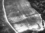
 Another
camp in Chotín which was discovered by aerial reconnaissance ca 6 km to the
north of the Danube on a low terrace close to the former branch of the Žitava
River could also be related to one of these military expeditions. The aerial
photographs show a 400-450 m long line of a ditch with a rounded corner. By
means of field verification it was ascertained that the V-shaped ditch was
ca 4 m wide and 2.7 m deep. Although there were no finds enabling a dating
directly
in the filling of the ditches, within their area numerous fragments of the
Roman military equipment datable to the late Antonine period were captured
by means
of a metal detector.
Another
camp in Chotín which was discovered by aerial reconnaissance ca 6 km to the
north of the Danube on a low terrace close to the former branch of the Žitava
River could also be related to one of these military expeditions. The aerial
photographs show a 400-450 m long line of a ditch with a rounded corner. By
means of field verification it was ascertained that the V-shaped ditch was
ca 4 m wide and 2.7 m deep. Although there were no finds enabling a dating
directly
in the filling of the ditches, within their area numerous fragments of the
Roman military equipment datable to the late Antonine period were captured
by means
of a metal detector.
 The
earthwork 2 in Mužla perhaps falls within the same period; its eastern line
and the related ditch has disturbed an older Germanic cottage which, apart
from
the typical local pottery, has also contained Samian ware of the central Gallic
workshop of Laxtucissa from the Antonine period providing a terminus p. q.
Besides
the examples mentioned above a great part of the camp with a rounded corner
in Hviezdoslavovo has been outlined during
aerial reconnaissance between two branches of the River Danube (Žitný ostrov).
The
earthwork 2 in Mužla perhaps falls within the same period; its eastern line
and the related ditch has disturbed an older Germanic cottage which, apart
from
the typical local pottery, has also contained Samian ware of the central Gallic
workshop of Laxtucissa from the Antonine period providing a terminus p. q.
Besides
the examples mentioned above a great part of the camp with a rounded corner
in Hviezdoslavovo has been outlined during
aerial reconnaissance between two branches of the River Danube (Žitný ostrov).
The deployment of the Roman military sites that may still be very markedly completed
by finds of weapons and other military equipment of Antonine date indicates
the main directions of the Roman penetrating into the regions to the north of
the Danube. At the same time it may disclose a lot about the strategic goals
of the Roman army at the time of the Marcomannic wars. Although the hitherto
picture of the spatial distribution of the Roman military installations north
of the Danube is incomplete for many reasons, a certain dissimilitarity in their
deployment may now be observed. The differences between the most important regions
located at the foreland of the Roman provinces to the north of the most important
starting points of the Roman campaigns, i.e. from the more easterly Brigetio
on one side and the more westerly Carnuntum on the other, are especially marked
in this context.
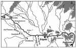
In the first case the reliably verified Roman camps concentrate along a relatively narrow strip on the northern bank of the Danube. Apart from five smaller encampments in the surroundings of the earth-timber fort in Iža there are large camps in Virt and Radvaň on the Danube situated 7 km further to the east, then the camp in Chotín 6 km north of the Danube, three camps in Mužla and finally the earthwork in the area of Žitný ostrov in Hviezdoslavovo. Especially the temporary camp concentrations in the surroundings of Iža and Virt-Radvaň are accepted as gathering grounds for the Roman thrusts into the land of the enemy. In this connection it is apparently important that lately a notable number of about 18 encampments in total have been discovered on the Pannonian territory, in the hinterland of the main outward route to the barbaricum, the legionary camp in Brigetio. It may be assumed that at least a part of them could also have been used as a base for the preparations of the Roman offensives beyond the Danube.
 |
 |
Such a spatial distribution of the Roman marching or temporary installations seems to support a conclusion that the main occupation area of the Romans on the territory that may altogether be put down to the Germanic tribe of Quads could be situated here. This was the location of the starting point from which the major campaigns have been launched into the barbarian territory, through the route alongside the Žitava and the Nitra Rivers, possibly also the Váh, further to the north as far as Laugaritio.
The situation of the region to the north of Carnuntum was apparently different. The marching camp at Engelhartstetten north of Carnuntum, further earthworks in Suchohrad, Závod and Bernhardsthal together with new discoveries at Stupava or Stilfried, and surprisingly numerous finds of weapons and military equipment of Antonine dating from different locations in this area provide evidence that the main invasion route into the northern barbarian territories must have run from Carnuntum along both banks of the Morava River to its confluence with the Thaya. Another road directly from Vindobona to the north may have run via Kollnbrunn where traces of a large marching camp were discovered. Although the marching route following the course of the Morava River further on to the north is not be put out of the question, the aerial observations have not yet been evidentiary enough to corroborate this presumption. However the advance of the Roman troops in the north-west direction into the area of the Thaya-Svratka Basin may be documented in a relatively convincing manner through the crop marks in Břeclav-Poštorná, Valtice, and above all an exemplary camp in Charvatská Nová Ves. Especially in the surroundings of the huge Roman hillfort at Burgstall-Mušov a surprising amount of further earthworks have been identified by aerial reconnaissance.
The results of more recent research show that the site was not
only used as an important military post but also as a principal supply base
for the units stationed in its surroundings. Such an interpretation of the site,
which might be also viewed as a large fortified „military settlement”, could
be confirmed by the discovery of workshops, baths and other internal structures
of a civilian nature. The long ditched fortification in the west of Burgstall
carving out a large tract of land may be understood as a demonstration of a
nucleus of the Roman occupation power, and is hitherto without precedence in
the region beyond the Roman Frontier.
In the western operational area of the Roman army to the north of Carnuntum,
where the action radius of the military activities has stepped deeper into the
Germanic interior, the main base of the Romans must have been accordingly situated
further to the north. A number of marching or temporary camps and other Roman
arrangements in the neighbourhood of the fortified site at Burgstall is an evidence
of one of the biggest concentrations of military installations in the area north
of the Middle Danube that was not only an immense gathering ground of the Roman
troops, a springboard for a further thrusts to the north, but also a nucles
of the Roman occupational power.
The dislocation of further earthworks along the main route running to the north (Ivaň, Přibice, Modřice) and new discoveries in the Middle and North Moravia (Olomouc-Neředín, Osek, Hulín-Pravčice) indicated that the marches of the Roman forces, rather than having terminated in the Thaya-Svratka Basin, have continued, most probably to the north of Brno and further on by an ancient link, the so-called Vyškov Gate, in the north-eastern direction to the northernmost parts of Moravia. Traces of Roman camps which were discovered in this region and have yet to be verified by a field research would show the effort of the Roman commands to close off the access route to the Suebian settlement area from the north, from the territory of the present-day south Poland.