See this text in ![]()
The colonia Augusta Raurica was founded as a veteran colony in 44
BC, by Lucius Munatius Plancus, on senatorial orders. The original settlement
cannot have lain within the area of the later town, as occupation there only
began in the 10s BC, and it may have been in Basel. Likewise, no indigenous
settlement has been found to date. The colony was re-founded by Augustus which
could have led to its reconstructed title colonia Paterna Munatia Felix
Apollinaris Augusta Emerita Raurica.
The town expanded during the 1st to the 3rd centuries AD and the first stone
structures were built around 40. The site of the lower town in Kaiseraugst was
occupied by a fort in the first half of the 1st century (c.20-50 AD). There
were unusually high levels of building activity in the Flavian period (from
69AD), the mid 2nd century and around 200.
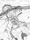
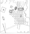
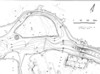
The 106ha urban area was divided into two areas: the older upper town of Augst
(77 ha) and the lower town of Kaiseraugst (29ha), which was only developed for
residential buildings in the early 2nd century. Both have orthogonal street
grids, but on slightly different alignments. The upper town contains 53 insulae,
with public and residential buildings, along with the western sanctuary area
and the south quarter, which was aligned on the highway leaving the town to
the south-west.
Two sections of the town's partial defences are known, one of which possesses
a V-shaped ditch. The defences date to the mid 1st century AD but they were
never completed and a break in the wall with two towers instead of a gate has
been found in the south-west.
|
 |
|
|
 |
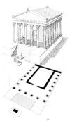
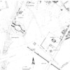
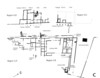
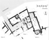
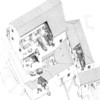
Plan |
Street grid with insulae |
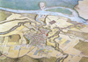
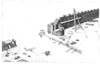
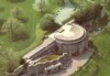
View of city, c.30 AD |
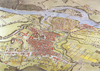
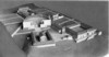
View of city c. 240 AD |
Reconstruction of the unfinished eastern city gate
during construction |
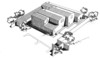
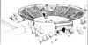
 Model of the urban centre with the Schönbühl temple and the southern forum in
the foreground and the main forum in the background
Model of the urban centre with the Schönbühl temple and the southern forum in
the foreground and the main forum in the background
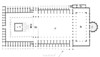
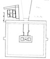
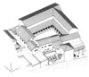
The main forum (insula 11-12) was divided by a road. An older timber forum can be dated to c.20 AD and the conversion to stone dates to after 70 AD with a replacement c. 140 AD. At the eastern end of the square stood a three-aisled basilica, flanked by two rows of chambers, to which a round curia was attached. In the western half the forum temple stood with an altar in a courtyard in front of it. The forum was located at the heart of the town and was the site for court sessions, council meetings of the decuriones and important business negotiations. The temple was dedicated to Dea Roma and the emperor Augustus.
 |
 |
 |
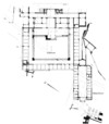
Ground plan of the main forum after 140 AD with reconstructions |
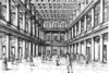
Reconstruction of the interior of the forum basilica
after 140 AD |
Forum temple. Plan and reconstruction |
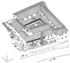
The southern forum (insula 14) consisted of a large courtyard surrounded by a series of rooms, containing shops. A long rectangular structure attached to the north-east side, which contained more rows of rooms, is interpreted as a market building (macellum).
Ground plan of the south forum
The central baths (Zentralthermen; insula 32) were built on the site of residential buildings in the last quarter of the 1st century AD and were extended in the 2nd century. They extended beyond the limits of the original insula to the north and south and were decorated with mosaics. The women’s baths (Frauenthermen, insula 17) date to the mid 1st century and were also extended in the 2nd.
 |
 |
|
Reconstructed ground plan of the central baths |
Reconstruction of the central baths |
Reconstructed ground plan of the women’s baths |
In the Grienmatt, west of insula 14, a building complex with hypocausted rooms and pools has been interpreted as a spa, on the evidence of an inscription. It adjoins a walled enclosure, which centres on a sumptuous sanctuary with a nymphaeum and a marble decorated door frame has survived from its interior decoration.
 |
 |
Reconstructed ground plan of the Grienmatt spa and
sanctuary |
Reconstruction of the Grienmatt spa |
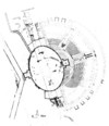
On the Schönbühl, a temple replaced a walled enclosure around the middle of the 2nd century AD. Firmly anchored in the Roman building tradition, it has been tentatively identified (on the basis of a fragmentary inscription) as a sanctuary to Mercury. The temple was surrounded by a double portico and the entrance formed an axial alignment with the scenic theatre.
 |
 |
Ground plan of the Schönbühl temple, the earlier period |
Ground plan of the Schönbühl temple with reconstruction
of the later period |
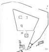
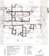
Three indigenous sanctuaries, each consisting of a Gallo-Roman temple surrounded
by a walled enclosure, were found in the Sichelen area, respectively to the
west and south-west of the Roman insulae.
 Southwestern
quarter of the town with the temple complex ‚Auf Sichelen’.
Southwestern
quarter of the town with the temple complex ‚Auf Sichelen’.
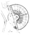
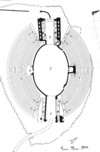
As stated, the theatre was aligned on the Schönbühl temple. It began as a scenic theatre (c. 65 – 110 AD) and, although it was rebuilt as an arena or amphitheatre in its second phase (c 110-200 AD), its third phase (c. 200 AD) saw it re-converted into a scenic theatre. Its audience seating capacity is estimated at 7000-8000.
 |
 |
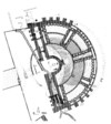 |
First theatre (ca. 65-110 AD) |
Second theatre, alterations for the amphitheatre (c.
110-200 AD) |
Third theatre (from c. 200 AD) |
| The amphitheatre proper made use of a natural valley and its north-westerly entrance was designed as an impressive archway. Seating for an audience of 5000 - 6000 was provided and the arena was built around 200 AD. | An eroded round structure on Gwerd island, which was linked to the town by a bridge, is variously interpreted as a Heroon, a monumental grave or a victory monument. | An inn (mansio) was located in insula 48 and consisted of a courtyard, surrounded on three sides with rooms (some of them heated), a baths and stabling. The complex's final expansion dates to the 3rd century. Another possible inn was found further west (Region 5b) and a structure with a large courtyard and flanking rooms (insula 7) is interpreted as possible official accommodation (praetorium). | |
 |
 |
 |
 |
Ground plan of the amphitheatre |
Reconstruction of the amphitheatre |
Rhine bridge and Gwerd Island |
Plan of the mansio |
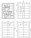
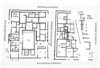
Residential buildings are known from all over the town (albeit some were studied by old excavations) and only the important features will be highlighted here. The ground plans allow the partial reconstruction of the original building plot lay-outs and particularly large and well appointed buildings can be found in several areas (insula 1, 30, 34). Most insulae contain 5-10 discrete residential units. These included shops or workshops facing the road and different crafts are known from all over town (insulae 5, 16, 23, 24, 31), although potteries seem to have been restricted to the periphery because of the fire risk (insulae 52 and 53). More strip buildings of both residential and commercial character have been found in the lower town, Kaiseraugst, which developed as a civilian site from around 100 AD.
 |
 |
 |
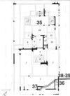
Insula 24, plan of the excavations, schematised
plan with reconstruction of building plots (below) |
Insula 23, plan with workshops and residential
areas |
Strip buildings in the Unterstadt (lower city) of
Kaiseraugst with possible building plots |
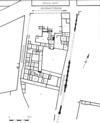
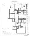
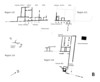
At the northern end of the upper town, Augst (insula 1-2), the earliest occupation began c. 20 AD, as timber buildings of uncertain ground plan, but a cul-de-sac between two of the buildings was later incorporated into the houses. Building in stone, if with timber-framed walls, started at the end of the 1st century and, whilst the original versions contained shops (tabernae) on the side, a later stone phase (mid 2nd century) in insula 1 replaced them with a villa-like structure surrounded by a garden, which furnishes a good example of up-market housing.
 |
 |
 |
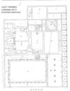
Ground plan of the walls encountered in insula
1 and the eastern part of insula 2 |
Reconstruction of Insula 1 and the eastern
part of Insula 2, first half of the 2nd century, view from the
north-east |
Reconstruction of Insula 1 and the eastern
part of Insula 2, after the mid 2nd century, view from the north-east |
The function of the building in insula 30 is debated, and it could be either a private residence, an inn or a club house. In the 1st century, the block had originally consisted of ten timber buildings, which were later replaced by two or three houses and, in its latest phase c. 200 AD, a series of luxurious rooms with mosaics and a bath suite, arranged around a courtyard. The neighbouring insula 31 shows a very different development. This was divided into five commercial units and contained a butcher’s shop and a small possible market hall.
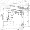
In the southern quarter (Regions 4 and 5) along the road leading to the west gate, potteries were active in the 1st century. Towards the end of the century, however, strip buildings with a roadside portico developed on the north side of the road whilst, to the south, a large hall was built in the early 2nd century, surrounded by other stone structures whose ground plans remain unclear. In the later 2nd century the plots along the roads remained stable but a large domus was built in its western half, to the south whilst to the east lay a building with a bath and two internal courtyards, which has been interpreted as a possible inn.
 |
 |
The southern town in the first half of the 2nd century |
The southern town in the second half of the 2nd and
the first half of the 3rd. century AD |
Along the southern limits of the built-up area in the lower town of Kaiseraugst (Flur Schmittmatt), a 2nd century building was found with a small internal courtyard and several commercial installations. These included a tavern with a larder and meat processing facilities in Room 1-9, and a fullery could be identified in rooms 10-11.
 |
 |
Ground plan of the building in Kaiseraugst- Schmidmatt |
Reconstruction of the building in Kaiseraugst-Schmidmatt |
A 6.5km long, masonry aqueduct brought drinking water from the Liestal. A distribution tank was located in the south of the town, with timber and lead pipes leading from it. Deep wells were found in the lower town.
 Archaeological
Park of Augst. Aerial view of the curia in the forum.
Archaeological
Park of Augst. Aerial view of the curia in the forum.
Museum
The finds from Augusta Raurica are on display in the Römermusem and Römerhaus
in Augst.
Text: Thomas Schmidts
W. Drack/R. Fellmann, Die Römer in der Schweiz (Stuttgart 1988) 323-337.
J. Ewald/M. Hartmann/Ph. Rentzel, Die römische Wasserleitung von Liestal nach Augst. Archäologie und Museum 36 (Liestal 1997).
A. R.Furger, Kurzführer Augusta Raurica. Führer durch Augst und Kaiseraugst 5 (Augst 1999).
A. R. Furger, Die urbanistische Entwicklung von Augusta Raurica vom 1. bis zum 3. Jahrhundert. Jahresbericht aus Augst und Kaiseraugst 15, 1994, 29-38.
A. R. Furger, Zur Wasserversorgung von Augusta Raurica. In: Mille fiori. Festschrift für Ludwig Berger (Augst 1998) 43-50.
Th. Hufschmid, Kastelen. 3. Die jüngeren Steinbauten in den Insulae 1 und 2 von Augusta Raurica. Untersuchungen zur baugeschichtlichen Entwicklung einer römischen Domus im 2. und 3. Jahrhundert n.Chr. Forschungen in Augst 23 (Augst 1996).
Th. Hufschmid/H. Sütterlin, Das Nebenforum von Augusta Raurica, ein macellum? Überlegungen zur Interpretation der "Forumsanlagen auf dem Neusatz". In: Mille fiori. Festschrift für Ludwig Berger (Augst 1998) 77-86.
L. Laur-Belart, Führer durch Augusta Raurica (Augst, 5. Aufl. 1988).
M. Martin, Bibliographie von Augst und Kaiseraugst 1911-1970. In: Beiträge und Bibliographie zur Augster Forschung, 1975, 289-371.
Out of Rome. Augusta Raurica/Aquincum. Das Leben in zwei römischen Provinzstädten. Ausstellungskatalog Augst/Budapest (Augst, Budapest 1997).
R. Schatzmann, Das Südwestquartier von Augusta Raurica. Untersuchungen zu einer städtischen Randzone. (Augst 2003).
M. Schaub/A. R. Furger, Panorama Augusta Raurica. 700 Jahre Stadtgeschichte in Rekonstruktionsbildern. Augster Museumshefte 31 (Augst 2001).
M. Schaub/B. Rütti, Das Osttor und die Stadtmauer von Augusta Raurica (Grabung 1993.52). Jahresbericht aus Augst und Kaiseraugst 15, 1994, 73-132.
K. Stehlin, Ausgrabungen in Augst 1890-1934. Forschungen in Augst 19 (Augst, 1994).
H. Sütterlin, Kastelen. 2. Die älteren Steinbauten in den Insulae 1 und 2 von Augusta Raurica. Forschungen in Augst 22 (Augst 1999).
Reports on the continuing excavations in Augst:
Forschungen in Augst 1, 1977 ff.
Jahresbericht aus Augst und Kaiseraugst 1,1980 ff.
Augster Museumshefte 1, 1976 ff.