See this text in ![]()
The long-established Celtic tribe of the Sequani was settled in the area between the Saône and the Swiss Jura and many surviving remains attest to the presence of an oppidum in Besançon by the late 2nd century BC. The status of civitas was granted by Augustus, leading to a continuous development from the LaTène into the imperial period. The settlement's redevelopment as a Roman town began in the late 1st century BC, but only a few glimpses of the original structure have been possible in the known excavations of public buildings. Towards the end of the second century a downturn in the city’s fortunes led to the abandonment of entire quarters and this could be linked to a crisis amongst the Sequani, hinted at by the written sources.
Celtic remains have been found in several locations throughout the later Roman
town. The earliest date to the 3rd century BC and remains of buildings are known
from 120 BC onwards.
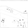
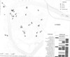 Distribution of Celtic finds discovered up to 1990.
A 6m wide defensive wall in Celtic tradition (murus Gallicus) was
constructed around 80 BC, and a section survives in the northern part of the
settlement in an area along the River Doubs (Remparts Dérasés), that has also
produced earlier graves.
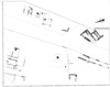
 Celtic remains with defences (Ramparts Dérasés).
Celtic houses occur at several sites in Besançon. They were rectangular (L.5-10m),
timber built structures, some of which had stone or timber lined cellars. One
large scale excavation (Parking de la Marie) has shown that the (120 BC – 40
BC) houses originally followed different orientations. Other sites offered examples
of residential buildings of the mid 1st century BC onwards (Banque de France,
Rue de Ronchaux) and in the LaTène period, the north-western part of the town
(Ilôt Pâris) housed workshops for potters and bronze workers.
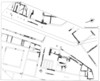
 Late LaTène residential buildings (Parking de la Marie Phase 1).
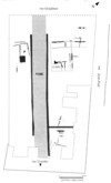
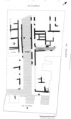
Within the mostly orthogonal street grid, insulae of different sizes have been found, ranging from 166 x 125m, up to 220 x 125m. Some insulae lie on a different orientation, suggesting that the town developed in several stages, and the west bank of the Doubs formed a further quarter, which was linked to the rest of the town by a bridge. The settlement's infrastructure seems to have developed predominately under Augustus, although there were no defences in the early and middle Imperial period.
|
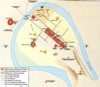 |
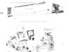
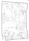
Town plan with the remains of public buildings highlighted |
Plan of Vesontio- Besançon |
The public buildings are hard to identify, as only small fragments of building
plans are known, and phasing information is in short supply.
Two stretches of walling, running west of the main road (Rue Moncey), formed
part of the northern wall of the forum and cryptoporticus. Modern plans suggest
that it was the site of a temple to the imperial cult, but this remains unconfirmed.
Further to the south lay a small semicircular feature, with associated columns
at its rear (Square A.-Castan), which is interpreted as a nymphaeum
but whether this was the end of the forum remains uncertain, as does the location
of the basilica. A theatre has been postulated in the immediate vicinity, although
alternative sites have been suggested south-west of the ‘nymphaeum’ and north
of the cryptoporticus (near St.Pierre).
![]() Northern end of the forum (rue Moncey)
Northern end of the forum (rue Moncey)
A large (diameter: 91.94m) circular building with a monumental entrance, west
of the forum, was a sanctuary, probably dedicated to Mars.
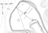
 Circular monumental building
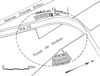
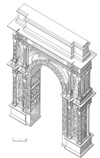
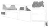
| In the north of the town (place du Marché) several rooms have been excavated, including one with an apse, which were probably parts of a larger public baths. | The amphitheatre was located in the quarter west of the Doubs. Two large sections have been found facing each other and the whole (138m long) complex was surrounded by radial walls. | A triumphal arch (Porte Noir) lay at the southern end of the main road (cardo maximus) and had reliefs showing mythological scenes and barbarians marching in front of the emperor. It dates to the 170s, and the reign of the Marcus Aurelius. |
 |
 |
|
Detail of the baths |
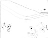
Ground plan of the amphitheatre |
Reconstruction of the triumphal arch (Porte Noir) |
At several points in the town it has been possible to document the continuous development of residential areas from the late LaTène period onwards. One large area (Parking de la Marie) was excavated near the circular temple of Mars. Here, the first stone building can be found in Phase 4 (1-15 AD), but most of the rest of the housing remained as small timber buildings, albeit decorated with wall plaster. The structure of the housing plots changed in the following phases. (from 15 AD onwards). The built-up area contained one larger (>1000sqm) building with an internal courtyard and high quality decoration, including mosaics, but there were also six smaller units, with a portico alongside the road. Roman occupation ceased here, as elsewhere in the town, in the second half of the 2nd century AD.
 |
 |
 |
Residential buildings in the Parking de la Marie Phase
3 (c. 30-1 AD)
|
Residential buildings in the Parking de la Marie Phase
4 (c. 1-15 AD)
|
Residential buildings in the Parking de la Marie Phase
5 (c. 15-20 AD)
|
North-west of the excavations discussed above, a second larger area of housing
has been excavated at the Palais de Justice. Late LaTène pits were encountered,
with stone building beginning in the first half of the 1st century AD. In the
Flavian period, a peristyle house was built with an omega-shaped basin in the
courtyard, and whose high standard of living was backed by mosaics and wall
paintings.
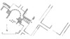
 Excavations at the Palais de Justice. Roman walls (grey) and Latène features
Another, similar sequence is known from the south of the town. (Banque de France),
where finds dating back to the mid 1st century BC are known, albeit without
associated house plans. The first stone buildings date to the mid 1st century
AD, whilst a residence decorated with mosaics was built around the mid 2nd century.
 Roman walling and mosaics (Banque de France)
In the north-western part of town (Ilôt Pâris), free-standing timber buildings, which already fronted onto a Roman road, were erected, over earlier LaTène structures, in Augustan times and a well developed stone-built neighbourhood developed around the mid 1st century AD.
 |
 |
Residential area (Ilôt Pâris) in the early 1st century
AD. |
Residential area (Ilôt Pâris) in the second half of
the 1st century and into the 2nd |
An artisans' quarter, containing potteries, glass workshops and copper alloy foundries grew up in the north of the city (Remparts Dérasés) and two glass working furnaces are known in houses, behind a portico.
 |
Stone structures in the artisan quarter (Remparts
Dérasés) |
A c. 10km long masonry aqueduct brought spring water from nearby Arcier to a distribution tank in the south of the city. The aqueduct pierced a hill (Porte Taillée) and existed by the late 2nd century AD, at the latest. Within the city the water was distributed via lead and clay pipes.
Visible remains
Roman remains (including the Porte Noir triumphal arch) can be found at various
points in the city of Besançon. The remains of a Roman house with mosaics (Banque
de France) are preserved in the basement of the Archaeological Institute.
Museum
The finds from Besançon are exhibited in the Musée des Beaux-Arts et d’Archéologie
and in the Musée Lapidaire.
Text: Thomas Schmidts
20 000 m3 d'histoire. Les fouilles du parking de la mairie à Besançon. Ausstellungskatalog Musée des Beaux-Arts et d'Archéologie Besançon, 23 mai-5 oct. 1992. (Besançon 1992).
J.-C. Barçon/L. Jaccottey, L'aqueduc romain de Besançon. Archéologia 355, 1999, 34-39.
G. Chouquer, Le plan de la ville antique et de la ville médiévale de Besançon. Revue Archéologique de l’Est et du Centre-Est 45,1-2 (Paris 1994) 361-407.
E. Frézouls, Les villes antiques de la France. 2,1. Germanie Supérieure. 1. Besançon, Dijon, Langres, Mandeure. (Strasbourg 1988) 7-178.
J.-O. Guilhot, Besançon (Doubs), Parking de la Mairie. Urbanisme et habitat. In: Die spätkeltische Zeit am südlichen Oberrhein (Basel 1994) 137-145.
L. Lerat, Dans Besançon gallo-romain ... Fouilles sous l'ancien parc de la Banque de France. Annales Littéraires de l'Université de Besançon 318 (Paris 1985).
L. Lerat, Besançon antique: Ville gallo-romaine, Musée des beaux-arts et d'archéologie, Musée lapidaire. Guides archéologiques de la France 18 (Paris 1990).
F. Passard/J.-P. Urlacher/V. Avanzi, Besançon, Saint-Jean (Doubs): structures en fosses et puits en contextes laténien et gallo-romain (1er siècle avant J.-C. -1er siécle après J.-C). Revue Archéologique de L’ Est 48, 1997, 167-218.
L. Vaxelaire/Ph. Barral, Besançon: de l'oppidum à la ville romaine. In: La naissance de la ville dans l'antiquité (Paris 2003) 239-261.
L. Vaxelaire/J.-J. Schwien, Besançon, rempart et quai sur le Doubs. Archéologue 58, 2002, 49-50.
L. Vaxelaire, Besançon: sauvetage d'un grand site antique. Archéologia 384, 2001, 6-9.
H. Walter, La Porte Noire de Besançon. Contribution à l'étude de l'art triomphal des Gaules. Centre de Recherche d'Histoire Ancienne 65 (Paris 1986).
H. Walter/J.-C. Barçon, Vesontio-Besançon.Collection Galliae
Civitates (Lyon 2004).