Lees deze text in
Newcomers
 In
the last half-century BC, new population groups arrived in the southern
Netherlands, and mixed with the local population. Around the beginning
of the first century AD there were at any rate two such new population
groups in the southern Netherlands whose name we know for certain: the
Batavians in the river area, and the Cananefates along the coast of
Zuid-Holland province. It is however difficult to pinpoint exactly
which group lived where. For more information, see ‘The province’s
indigenous population’.
In
the last half-century BC, new population groups arrived in the southern
Netherlands, and mixed with the local population. Around the beginning
of the first century AD there were at any rate two such new population
groups in the southern Netherlands whose name we know for certain: the
Batavians in the river area, and the Cananefates along the coast of
Zuid-Holland province. It is however difficult to pinpoint exactly
which group lived where. For more information, see ‘The province’s
indigenous population’.
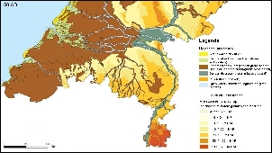
Landscape
 Archaeological
remains repeatedly highlight the differences (and similarities) between
regions in the Netherlands. These regions correlate well with the
different types of landscape, as the natural environment had a strong
bearing on whether an area was suitable for occupation. In the Roman
period large parts of our country were wet and barely accessible.
However, this did not mean that they were deserted; they were simply
occupied differently to drier areas. The Netherlands can in fact be
divided into a high, dry Pleistocene part in the south and east of the
country (the yellow and orange areas on the map) and a wet Holocene
part in the north and west (shown in blue).
Archaeological
remains repeatedly highlight the differences (and similarities) between
regions in the Netherlands. These regions correlate well with the
different types of landscape, as the natural environment had a strong
bearing on whether an area was suitable for occupation. In the Roman
period large parts of our country were wet and barely accessible.
However, this did not mean that they were deserted; they were simply
occupied differently to drier areas. The Netherlands can in fact be
divided into a high, dry Pleistocene part in the south and east of the
country (the yellow and orange areas on the map) and a wet Holocene
part in the north and west (shown in blue).
The land in the Pleistocene area formed during the last ice age, and
consists mainly of sandy soils. During the ice age, glaciers pushed up
large quantities of earth, forming ice-pushed ridges which give the
land some relief. Only the very south of Limburg province, with its
loamy loess deposits (orange areas on the map) is really hilly. People
have always been attracted to loess, as it produces such fertile soil.
The Holocene part was formed after the last ice age ended, some 10,000
years ago, in the delta of several rivers, and by the sea. The rivers
meandered through the low-lying landscape on their way to the sea. This
part of the country consists largely of clay and peat. Small rivers
with higher banks wound their way through the peatlands. However, most
of the land was wet and virtually inaccessible.
Farmers on wet and dry soils
It is interesting to note that virtually all pre-Roman settlements are similar in size and in the archaeological finds they yield. The fact that there were few, if any, central places in the Netherlands was probably due among other things to the traditions and way of life of the indigenous population. The wet areas and the sandy soils of Brabant and the east were populated mainly by stockbreeders who reared cattle and horses. Arable farming probably produced too small a yield in these areas. Only in the very south of the country, on the loamy loess soils of southern Limburg, was arable farming the mainstay of the population.
Cattle farmers
Indigenous stockbreeders kept cattle in their farmhouses, which included both living quarters and animal stalls under one roof. Grazing cattle required a lot of land, so settlements lay far apart, and it would be impossible for a stockbreeder to live in a town or larger settlement. Indeed, there were probably no such settlements at that time. The region around Kessel and Lith nevertheless seems to have played a central role in the river area, though it should be noted that the eastern river area is one of the most intensively investigated parts of the country. Kessel and Lith are located at the spot where two major rivers – the Waal and the Maas – meet. This was an important location. An important shrine here attracted people from far and wide even before the arrival of the Romans. Similar shrines were also built in Elst and in the village of Empel in Brabant. However, there was probably no such thing as a capital at that time.
Unique Batavians
We know from
historical sources that the Batavians had a special status in the Early
Roman period.
They had probably befriended and concluded agreements with the Romans
before
they moved to the Dutch river area. This friendship continued after the
Batavians moved. The agreements, under which the Batavians were not
required to
pay taxes in the form of money or goods, remained in force. They were
however
obliged to provide soldiers, and Batavian warriors were highly prized.
Large
numbers of young men left their families and joined the Batavian units
in the
Romany army. The other population groups in the Netherlands, including
the
Cananefates and probably also the Sturii and Marsaci, also provided
troops for
the Romans. All soldiers came into contact with Roman culture during
their
military service. They were obliged to adopt a Roman soldier’s way of
life, and
many of them therefore learnt to read and write.
Many of the settlements that have been excavated date from around the beginning of the present era. However, some of them appear to have been occupied as long ago as the mid-first century BC, remaining in use into the Roman period.
Shifting farmsteads
In the Iron Age, land division took the form of ‘shifting farmsteads’. Iron Age farmhouses, which combined animal and human accommodation under one roof, were in the middle of the fields. Small barns for storing the harvest stood beside the main house. The farmstead was regularly moved, so that other fields could be brought under cultivation, while the farmer remained close to his land.
A permanent pitch
From the Late Iron Age onwards, people began to settle at fixed spots in the landscape. When a house needed replacing, it would be rebuilt on more or less the same site. A shallow ditch (probably with a hedge or fence) would be dug around the farmhouse and outbuildings. This clearly divided the farmstead from its surroundings, and prevented animals – wild or domesticated – from entering or leaving the farm. The ditch also seems to have served to distinguish each farmstead from the rest, as people apparently became more conscious of their possessions. Some larger settlements were in fact entirely fenced in.
Changes
The Iron Age
occupation differed in a number of respects from the occupation in the
Roman
period. The changes to houses and settlements at the end of the Iron
Age, in
the last fifty or hundred years BC, are striking. Because people were
living
for longer on the same spot, their houses became more robust. The
roof-bearing
central pillars became thicker, and stood in deeper pits. The
orientation of
the houses also seems to have changed. For the first time, larger
settlements
comprising more than a few farms began to emerge, as people developed a
tendency to live in greater proximity to each other as they became more
settled.
 The
majority of settlements consisted of no more than three or four
contemporaneous farms with outbuildings and wells. The people still
lived in farmhouses combining human and animal living quarters. If we
map the occurrence of certain house types and different types of
handmade pottery, we find that certain customs dominated in certain
regions. The boundaries between the different regions appear to
coincide with the boundaries between different landscapes and soil
types. The regions are also reasonably consistent with the territories
of certain population groups as described in Roman texts, although such
apparent links should be viewed with caution. In this way, three
regions can be distinguished in what was later to be the Roman part of
the Netherlands: the southeastern Netherlands (now the provinces of
Noord-Brabant and Limburg), the coastal area (Zuid-Holland and Zeeland)
and the river area (part of the present-day provinces of Gelderland and
Utrecht). Though slight differences can be discerned within this rough
division, there seems to have been little difference between regions in
terms of the size and layout of settlements.
The
majority of settlements consisted of no more than three or four
contemporaneous farms with outbuildings and wells. The people still
lived in farmhouses combining human and animal living quarters. If we
map the occurrence of certain house types and different types of
handmade pottery, we find that certain customs dominated in certain
regions. The boundaries between the different regions appear to
coincide with the boundaries between different landscapes and soil
types. The regions are also reasonably consistent with the territories
of certain population groups as described in Roman texts, although such
apparent links should be viewed with caution. In this way, three
regions can be distinguished in what was later to be the Roman part of
the Netherlands: the southeastern Netherlands (now the provinces of
Noord-Brabant and Limburg), the coastal area (Zuid-Holland and Zeeland)
and the river area (part of the present-day provinces of Gelderland and
Utrecht). Though slight differences can be discerned within this rough
division, there seems to have been little difference between regions in
terms of the size and layout of settlements.
The southeastern Netherlands: arable farmers and stockbreeders
 We
know that
the Texuandri and the Cugerni lived in the southeastern Netherlands
around the
beginning of the present era. The region divides into two main areas:
the
fertile loess soils in the hills of southern Limburg, and the poorer
sandy
soils of Brabant and northern Limburg. A continuous development in
house
building can be seen in this region. The farmhouses were two-aisled, a
row of
roof-bearing pillars in the middle of the house dividing it in two. The
pottery
also shows continuous development from the Iron Age into the Roman
period.
Smaller houses are also found sporadically in this region, mainly in
the loess
area. They were probably separate houses or animal stalls, instead of
the
combined farmhouses found elsewhere.
We
know that
the Texuandri and the Cugerni lived in the southeastern Netherlands
around the
beginning of the present era. The region divides into two main areas:
the
fertile loess soils in the hills of southern Limburg, and the poorer
sandy
soils of Brabant and northern Limburg. A continuous development in
house
building can be seen in this region. The farmhouses were two-aisled, a
row of
roof-bearing pillars in the middle of the house dividing it in two. The
pottery
also shows continuous development from the Iron Age into the Roman
period.
Smaller houses are also found sporadically in this region, mainly in
the loess
area. They were probably separate houses or animal stalls, instead of
the
combined farmhouses found elsewhere.

Along the coast: living with water
 The
coastal
region was mainly characterised by wet peaty areas and higher coastal
barriers.
The latter would have been the only parts of this landscape that really
leant
themselves to occupation. Prior to the Roman period, large tracts of
land
behind the dunes were inundated and in some areas the soil was for a
long time
too wet to live on. This can often be clearly seen in excavations
around the
Maas estuary. A layer of clay deposited during flooding is often found
between
Iron Age and Roman features. In the peaty area of Midden-Delfland (just
north
of the Maas estuary), however, signs of continuous occupation have been
found.
Remarkably, settlements on the peat appear to have been continuously
occupied,
while those on clay were not.
The
coastal
region was mainly characterised by wet peaty areas and higher coastal
barriers.
The latter would have been the only parts of this landscape that really
leant
themselves to occupation. Prior to the Roman period, large tracts of
land
behind the dunes were inundated and in some areas the soil was for a
long time
too wet to live on. This can often be clearly seen in excavations
around the
Maas estuary. A layer of clay deposited during flooding is often found
between
Iron Age and Roman features. In the peaty area of Midden-Delfland (just
north
of the Maas estuary), however, signs of continuous occupation have been
found.
Remarkably, settlements on the peat appear to have been continuously
occupied,
while those on clay were not.
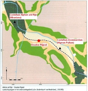
We know from historical sources that the Cananefates lived in the coastal area between the Maas and the Rhine at the beginning of the Roman period. The Marsaci, Sturii and Frisiavones lived to the south of the Maas estuary, in present-day Zeeland and the west of Brabant province.
The pottery
and houses of all coastal inhabitants, including those north of the
Rhine, are very similar. The differences
between the housing and pottery of the Frisians to the north of the
Rhine (who were never really part of the Roman empire) and those of the
inhabitants of the
coastal zone to the south became more marked during the Roman period.
 However,
around the beginning of the present era, the houses in both regions
were
largely two- or three-aisled, although single-aisled houses have also
been
found in several places south of the Rhine. The three-aisled houses to
the south
of the Rhine had an extra feature: the outside posts stood diagonally,
forming
a kind of ‘A’ shape. Furthermore, in Midden-Delfland (an area that lies
between
Rotterdam, Delft, The Hague and the coast), ‘wall-ditch houses’ from
the first
half of the first century AD have been found. Traces of such houses are
found
in the soil in the form of a ditch surrounding a turf embankment. This
type of
house had already been found in Assendelft in Noord-Holland province,
well north
of the Rhine.
However,
around the beginning of the present era, the houses in both regions
were
largely two- or three-aisled, although single-aisled houses have also
been
found in several places south of the Rhine. The three-aisled houses to
the south
of the Rhine had an extra feature: the outside posts stood diagonally,
forming
a kind of ‘A’ shape. Furthermore, in Midden-Delfland (an area that lies
between
Rotterdam, Delft, The Hague and the coast), ‘wall-ditch houses’ from
the first
half of the first century AD have been found. Traces of such houses are
found
in the soil in the form of a ditch surrounding a turf embankment. This
type of
house had already been found in Assendelft in Noord-Holland province,
well north
of the Rhine.
The river area: between north and south
The river area
was home to the Batavians in the last half-century BC. Their houses
clearly
reflect the area’s position between the north and the south. Some are
two-aisled, resembling those in the southern sandy areas. Other houses
are
three-aisled, as commonly found to the north of the Rhine. Many houses
were in
fact a combination of two traditions, with a three-aisled and a
two-aisled
part. The former probably housed the animals. Smaller houses with no
animal
stalls also occurred in the region in the Early Roman period. The
settlements
were sometimes separated from the outside world by ditches. These
ditches also
provided essential drainage, of course. In terms of finds, too, the
Batavians
differ from the other population groups, for example in terms of coins
that are
found only in their territory.
 |
 |
Dating problems
 Indigenous
settlements continued to exist throughout the entire Roman period. Some
of them
were continuations of Iron Age settlements. It is however difficult to
establish when the first people came to live in a settlement, as most
of the
pottery found there tends to be handmade. This kind of pottery is
difficult to
date accurately, so such settlements are generally held to have been
established some time between 50 BC and AD 50. Only when a settlement
is
comprehensively excavated does it become easier to determine an
accurate start
date, on the basis of the buildings found, among other things.
Indigenous
settlements continued to exist throughout the entire Roman period. Some
of them
were continuations of Iron Age settlements. It is however difficult to
establish when the first people came to live in a settlement, as most
of the
pottery found there tends to be handmade. This kind of pottery is
difficult to
date accurately, so such settlements are generally held to have been
established some time between 50 BC and AD 50. Only when a settlement
is
comprehensively excavated does it become easier to determine an
accurate start
date, on the basis of the buildings found, among other things.
Same people, new
settlement
 It
is rarely possible to demonstrate continuous occupation from the Late
Iron Age into the Roman period. This does not however mean that the
people disappeared, or that the transition to the Roman period brought
new people to the settlement. It is quite possible that settlements
moved, so a settlement from the beginning of the Roman period that
looks new might in fact already have existed for some time.
It
is rarely possible to demonstrate continuous occupation from the Late
Iron Age into the Roman period. This does not however mean that the
people disappeared, or that the transition to the Roman period brought
new people to the settlement. It is quite possible that settlements
moved, so a settlement from the beginning of the Roman period that
looks new might in fact already have existed for some time.
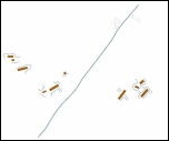
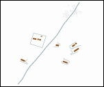
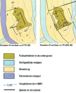
Small settlements grow larger
Most small
settlements of no more than three or four contemporaneous farms
underwent few
changes. However, some grew in the first century into larger, sometimes
enclosed settlements. Examples of this include the settlements at Wijk
bij Duurstede-De Horden ,
Houten-Overdam, Oss-Westerveld, Hoogeloon and Voerendaal-Ten Hove.
 |
|
New houses
New pots
 The
Romanisation process can be seen in the finds made during excavations.
Despite
the presence of the Romans, in the first century AD the inhabitants of
the
entire southern Netherlands continued to use handmade pottery they
produced
themselves. Once the Romans had been in the Netherlands for a while,
however,
the indigenous inhabitants used more and more thrown pottery made on a
potter’s
wheel at a central workshop. This technique had been introduced by the
Romans.
The potters sold their wares in large parts of the province, and
handmade
pottery was used less and less. In the course of the second century
handmade
pottery in fact largely disappeared from most settlements. Only the
Cananefates
in the coastal area to the north of the Maas estuary stuck to the old
pottery
for longer. Even when thrown pottery was readily available, they still
preferred to use handmade pots.
The
Romanisation process can be seen in the finds made during excavations.
Despite
the presence of the Romans, in the first century AD the inhabitants of
the
entire southern Netherlands continued to use handmade pottery they
produced
themselves. Once the Romans had been in the Netherlands for a while,
however,
the indigenous inhabitants used more and more thrown pottery made on a
potter’s
wheel at a central workshop. This technique had been introduced by the
Romans.
The potters sold their wares in large parts of the province, and
handmade
pottery was used less and less. In the course of the second century
handmade
pottery in fact largely disappeared from most settlements. Only the
Cananefates
in the coastal area to the north of the Maas estuary stuck to the old
pottery
for longer. Even when thrown pottery was readily available, they still
preferred to use handmade pots.
Rust na de opstand
Tijdens de Romeinse tijd werden er veel nieuwe
inheemse
nederzettingen op het platteland gebouwd. Vooral nadat de Bataafse
opstand in
70 na Chr. was neergeslagen. Na deze opstand werd het rustig langs de
Rijn. De
handel kwam goed op gang en met de economie ging het steeds beter. De
invloed
van de Romeinse aanwezigheid op het platteland werd steeds zichtbaarder
bij het
verschijnen van enkele grote herenboerderijen in 'Romeinse' stijl (de
villae)
en kleine plattelandscentra. De bevolking groeide onder de gunstige
omstandigheden. Oude inheemse nederzettingen groeiden en er werden
nieuwe
nederzettingen gesticht.
Peace follows uprising
Many new indigenous settlements were built in rural areas during the Roman period, particularly after the Batavian revolt was suppressed in AD 70. After this revolt, the area along the Rhine enjoyed a long period of peace. Trade developed and the economy flourished. The impact of the Roman presence on the countryside became more and more visible, as several large ‘Roman-style’ homesteads (villae) and small rural centres appeared. The circumstances were conductive to population growth, and old indigenous settlements expanded at the same time as new settlements were being established.
New settlements based on old traditions
 These
new
settlements barely differed from the old ones, if at all, and old
traditions
were upheld. The presence of the Romans did not stop most indigenous
country
dwellers from building their houses according to their own traditions.
One
example of a new indigenous settlement has been found in Venray-de
Hulst. There
was already a settlement there in the Late Iron Age, but it was
abandoned by
the Early Roman period. In the second century, a new settlement was
established
a short distance away. This new settlement probably existed for 150
years. The
excavation plan shows many houses, though they would not all have
existed at
the same time. The settlement actually consisted of a few
contemporaneous farms
with outbuildings and wells.
These
new
settlements barely differed from the old ones, if at all, and old
traditions
were upheld. The presence of the Romans did not stop most indigenous
country
dwellers from building their houses according to their own traditions.
One
example of a new indigenous settlement has been found in Venray-de
Hulst. There
was already a settlement there in the Late Iron Age, but it was
abandoned by
the Early Roman period. In the second century, a new settlement was
established
a short distance away. This new settlement probably existed for 150
years. The
excavation plan shows many houses, though they would not all have
existed at
the same time. The settlement actually consisted of a few
contemporaneous farms
with outbuildings and wells.
Neighbours
 Lieshout
has some good examples of the type of settlement found in the southern
Netherlands. Three settlements have been found here within a distance
of 400
metres. The largest was established around the beginning of the present
era,
and was abandoned sometime during the second half of the second
century. It
probably consisted of only two contemporaneous farms during the early
and final
phases. During its heyday, in the second half of the first century and
early
second century, however, there were probably four farms there.There
was at least one farm some 400 metres to the
west of the large settlement during the same period, around the end of
the
first century. Around AD 200, when the larger settlement had already
been
abandoned, two smaller settlements stood no more than 250 metres apart
there.
They probably did not last long, however, and had at any rate been
abandoned by
the middle of the third century. This is not unusual, in fact, as the
majority
of the indigenous-Roman occupation appeared to cease in the southern
Netherlands around AD 225.
Lieshout
has some good examples of the type of settlement found in the southern
Netherlands. Three settlements have been found here within a distance
of 400
metres. The largest was established around the beginning of the present
era,
and was abandoned sometime during the second half of the second
century. It
probably consisted of only two contemporaneous farms during the early
and final
phases. During its heyday, in the second half of the first century and
early
second century, however, there were probably four farms there.There
was at least one farm some 400 metres to the
west of the large settlement during the same period, around the end of
the
first century. Around AD 200, when the larger settlement had already
been
abandoned, two smaller settlements stood no more than 250 metres apart
there.
They probably did not last long, however, and had at any rate been
abandoned by
the middle of the third century. This is not unusual, in fact, as the
majority
of the indigenous-Roman occupation appeared to cease in the southern
Netherlands around AD 225.
Settlements in
the river area were similar to those in the southern Netherlands. Only
the
building methods differed. Farms also included small barns alongside
the
farmhouse. As in the southern Netherlands, wells provided fresh water
if there
was no surface water nearby.
 Notably,
there
were also indigenous settlements near to the Rhine, the border of the
Roman empire. Some archaeologists believe that
there was a military zone along both sides of the border which was
entirely
controlled by the army. If there was indeed such a zone in the
Netherlands,
this apparently did not mean that no indigenous people were allowed to
live
there. Several indigenous settlements have been excavated along the
Roman
border in the last few years, so the idea of a military zone along the
border
which was exclusively reserved for the military would not appear to
apply to
the Netherlands. Some of the settlements date to between AD 40/50 and
AD 200.
This means that they were built in the period when the border was
finalised,
and several new fortresses were built. The settlements ceased to exist
at more
or less the same time as a period of unrest along the border. The
settlements
near the border were small, like those in the rest of the country, with
no more
than three or four contemporaneous farms. The farms were exactly like
those in
other indigenous settlements. Farmers and their animals lived under one
roof,
in a farmhouse combining both human and animal quarters. They made most
of
their pots themselves, though later they made grateful use of the
attractive,
robust thrown pots that the Romans had imported. There were probably
therefore
no soldiers living in these settlements, as archaeologists have been
known to
conjecture, just ordinary indigenous farmers. The farmers in the border
area
could sell their surplus grain and cattle to the Roman military camps,
which
meant they would have encountered Roman goods and customs.
Notably,
there
were also indigenous settlements near to the Rhine, the border of the
Roman empire. Some archaeologists believe that
there was a military zone along both sides of the border which was
entirely
controlled by the army. If there was indeed such a zone in the
Netherlands,
this apparently did not mean that no indigenous people were allowed to
live
there. Several indigenous settlements have been excavated along the
Roman
border in the last few years, so the idea of a military zone along the
border
which was exclusively reserved for the military would not appear to
apply to
the Netherlands. Some of the settlements date to between AD 40/50 and
AD 200.
This means that they were built in the period when the border was
finalised,
and several new fortresses were built. The settlements ceased to exist
at more
or less the same time as a period of unrest along the border. The
settlements
near the border were small, like those in the rest of the country, with
no more
than three or four contemporaneous farms. The farms were exactly like
those in
other indigenous settlements. Farmers and their animals lived under one
roof,
in a farmhouse combining both human and animal quarters. They made most
of
their pots themselves, though later they made grateful use of the
attractive,
robust thrown pots that the Romans had imported. There were probably
therefore
no soldiers living in these settlements, as archaeologists have been
known to
conjecture, just ordinary indigenous farmers. The farmers in the border
area
could sell their surplus grain and cattle to the Roman military camps,
which
meant they would have encountered Roman goods and customs.
New land
Many new
settlements were built in the coastal area around the beginning of the
present
era, partly because more areas fell dry and became accessible for
occupation
and farming. The number of settlements rose sharply during the Roman
period.
Different building styles
 The
predominant building style along the entire coast was the two- or
three-aisled
house. Single-aisled houses were also found to the south of the Rhine.
Despite
the major similarities within the coastal area to the south of the
Rhine,
the Maas estuary appears to marked a boundary.
The differences between the areas to the north and south of the estuary
became
more pronounced during the course of the Roman period. This can be seen
above
all in the pottery. Inhabitants of the area to the north of the estuary
continued to use their own indigenous pottery for a long time, even
when others
had already switched to using pottery introduced by the Romans.
The
predominant building style along the entire coast was the two- or
three-aisled
house. Single-aisled houses were also found to the south of the Rhine.
Despite
the major similarities within the coastal area to the south of the
Rhine,
the Maas estuary appears to marked a boundary.
The differences between the areas to the north and south of the estuary
became
more pronounced during the course of the Roman period. This can be seen
above
all in the pottery. Inhabitants of the area to the north of the estuary
continued to use their own indigenous pottery for a long time, even
when others
had already switched to using pottery introduced by the Romans.
Farmers on the peatlands
 To
date, most
of the settlements found in Midden-Delfland, a large peaty area north
of the
Maas estuary, have been new. There is some evidence of a settlement on
the
peat, which was occupied from the Late Iron Age into the Roman period.
However,
most Late Iron Age farmers left their old home and moved their
settlements to sandy
creeks that had recently dried up and were higher and drier than the
surrounding wetlands. Occupation on peat causes the ground to slowly
sink under
the weight of the house and as a result of drainage through ditches. In
the
course of time, a dried-up sandy creek will therefore ‘rise’ above the
surrounding peatlands. Only small settlements have been excavated to
date,
usually consisting of only one house at a time. The settlement site
would be
defined by natural boundaries. In this way, a strip of settlements
formed along
the higher ridges in the landscape during the second century. People
often
built a small mound (terp) on which to build their house. The terps
consisted
mainly of turf and dung. The buildings in Midden-Delfland were often
built of
turf. Sometimes a house would be repeatedly rebuilt at the same spot by
each
successive generation, causing the site to be raised further and
further.
Hearths and ovens have been found both inside and outside the houses.
To
date, most
of the settlements found in Midden-Delfland, a large peaty area north
of the
Maas estuary, have been new. There is some evidence of a settlement on
the
peat, which was occupied from the Late Iron Age into the Roman period.
However,
most Late Iron Age farmers left their old home and moved their
settlements to sandy
creeks that had recently dried up and were higher and drier than the
surrounding wetlands. Occupation on peat causes the ground to slowly
sink under
the weight of the house and as a result of drainage through ditches. In
the
course of time, a dried-up sandy creek will therefore ‘rise’ above the
surrounding peatlands. Only small settlements have been excavated to
date,
usually consisting of only one house at a time. The settlement site
would be
defined by natural boundaries. In this way, a strip of settlements
formed along
the higher ridges in the landscape during the second century. People
often
built a small mound (terp) on which to build their house. The terps
consisted
mainly of turf and dung. The buildings in Midden-Delfland were often
built of
turf. Sometimes a house would be repeatedly rebuilt at the same spot by
each
successive generation, causing the site to be raised further and
further.
Hearths and ovens have been found both inside and outside the houses.
Everything in its place
Farmsteads
were laid out using a ditch system, which also provided drainage. The
ditches
created a number of blocks, each of which had its own function. The
house, the
vegetable garden, the outdoor animal shelters and the well were all
surrounded
by their own ditch. An example of this system can be seen at the Woudse
Polder
settlement.
Living on a terp
 The
remains
found in the Dorppolder near Schipluiden were so well preserved that
many
details of the structure of the houses could be seen. The oldest house
dated
from the beginning of the first century AD. It stood on a small terp
made of
clay sods and dung. Each successive house was built on the remains of
the
previous one, and the most recent one dates from around AD 120. The
farmstead
was surrounded by a fence. The wet soil had also preserved remains of
the paths
leading to the house, which were made of branches. The floor of the
house
consisted of layers of dung and reeds. A path of reed or straw matting
had been
laid in the stalls, and the cattle stood between wattle partitions.
The
remains
found in the Dorppolder near Schipluiden were so well preserved that
many
details of the structure of the houses could be seen. The oldest house
dated
from the beginning of the first century AD. It stood on a small terp
made of
clay sods and dung. Each successive house was built on the remains of
the
previous one, and the most recent one dates from around AD 120. The
farmstead
was surrounded by a fence. The wet soil had also preserved remains of
the paths
leading to the house, which were made of branches. The floor of the
house
consisted of layers of dung and reeds. A path of reed or straw matting
had been
laid in the stalls, and the cattle stood between wattle partitions.
 Connecting
ditches
Connecting
ditches
A large number
of drainage ditches were dug to keep the settlements in Midden-Delfland
dry.
They flowed into a main ditch that was well maintained and regularly
dredged.
This main ditch formed part of a much wider parcelling system
consisting of
ditches, which divided the land outside the settlement into blocks of
arable
land and pasture. The settlement was therefore situated within the
parcelling
system, whose ditches connected several settlements. The division of
land
became stricter during the Roman period, and it has been demonstrated
that
standard dimensions were used, indicating that land use was well
organised,
perhaps even by the Roman authorities.
What is a villa?
 Many
new
settlements were founded during the Roman period. The most striking of
them
were the villae, which first appeared around the beginning of the
second
century. A Roman villa was a large homestead in the countryside. It
took the
form of a complex, with a main building and auxiliary buildings. One or
more of
the buildings would often feature architectural elements introduced by
the
Romans, such as stone walls, pillars and roof tiles. A villa produced a
surplus
of agricultural produce that could be sold in the towns or to the army.
Sometimes the owner would live at the villa, though some were also run
by a
bailiff or tenant. Villae were usually large farms, though some were
also
involved in non-agricultural activities.
Many
new
settlements were founded during the Roman period. The most striking of
them
were the villae, which first appeared around the beginning of the
second
century. A Roman villa was a large homestead in the countryside. It
took the
form of a complex, with a main building and auxiliary buildings. One or
more of
the buildings would often feature architectural elements introduced by
the
Romans, such as stone walls, pillars and roof tiles. A villa produced a
surplus
of agricultural produce that could be sold in the towns or to the army.
Sometimes the owner would live at the villa, though some were also run
by a
bailiff or tenant. Villae were usually large farms, though some were
also
involved in non-agricultural activities.
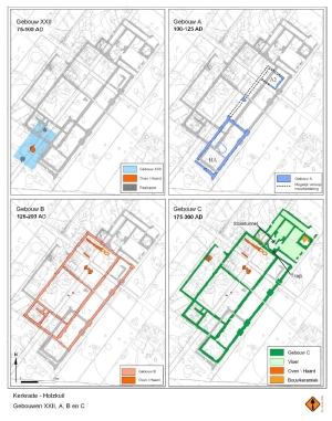
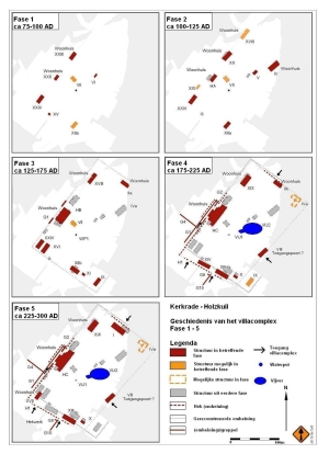
From wood to stone
The new villae
were sometimes built as simple wooden structures. Only later, in the
course of
the second century, were they rebuilt with stone foundations –
primarily the
main building, but also often some of the outbuildings. This
development can be
seen in the villa at Kerkrade-Holzkuil, in the fertile loess area of
southern
Limburg.
Settlements become villae
Besides the
new villae, a number of larger enclosed settlements were rebuilt in the
late
first and early second centuries. A large Roman-style main building
with
several auxiliary buildings would be built on the site of the old
farms. The
structure of the settlement was sometimes radically altered to create
an open
central courtyard, making it a true villa. Examples include the villae
at
Voerendaal-Ten Hove and Neerharen-Rekem (Belgium). Both are in the
fertile
loess area of the south.
 |
 |
 |
Not quite a real villa
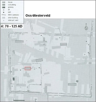
In other settlements, though an actual villa was not built, there was clearly some Romanisation of the buildings in the late first and early second centuries. One example is the enclosed settlement at Oss-Westerveld, where there was already a single homestead using specially imported Roman goods in the Early Roman period.
 A
special house was built at this homestead at the end of the first
century. Though it was still a traditional two-aisled structure, it had
extra
posts around the edge, which have been interpreted as a colonnade
(porticus).
Such features were not found in indigenous building traditions; they
had been
adopted from Roman architecture. This special house was surrounded by
its own
ditch. Beyond this ditch the rest of the settlement comprised
traditional
farmhouses combining living quarters and animal stalls. Though the
entire
settlement is reminiscent of a Roman villa, the traditional buildings
and
layout are clearly not. Such settlements, similar to but not quite real
villae,
are known as proto-villae or villa-like settlements.
A
special house was built at this homestead at the end of the first
century. Though it was still a traditional two-aisled structure, it had
extra
posts around the edge, which have been interpreted as a colonnade
(porticus).
Such features were not found in indigenous building traditions; they
had been
adopted from Roman architecture. This special house was surrounded by
its own
ditch. Beyond this ditch the rest of the settlement comprised
traditional
farmhouses combining living quarters and animal stalls. Though the
entire
settlement is reminiscent of a Roman villa, the traditional buildings
and
layout are clearly not. Such settlements, similar to but not quite real
villae,
are known as proto-villae or villa-like settlements.

|
 |
From settlement to villa: a big step
The biggest
difference between indigenous settlements and Roman villae lay in the
fact that
villae had to make a profit from the sale of their agricultural
produce. They
therefore no longer produced merely for their own consumption, but for
trading.
This was a new phenomenon in the Netherlands. The villa-like
settlements were
probably also commercial operations, but the inhabitants were less
concerned
with the appearance of the settlement. ‘Real’ villa buildings differed
considerably from traditional buildings in terms of their appearance,
as they
included Roman architectural features. Villa-like settlements or
proto-villae
did not therefore have the appearance of a ‘full-blown’ villa. It is
not
certain whether such a settlement would ever have been able to develop
into a
‘real’ villa. It took a lot of money to build a villa in the true Roman
style,
and most settlements would probably not be able to afford it. However,
they
might be able to pay for a colonnade around a traditional wooden house,
to give
it a more Roman appearance. Another possibility is that, though these
people
could afford to build a villa, they chose not to, as they had no desire
to
adopt Roman culture.
The indigenous wealthy
It would
appear that the indigenous people of the Netherlands themselves often
undertook the
construction of a villa, as suggested by the Late Iron Age or Early
Roman
period settlements found immediately beneath a number of villa.
Villa-like settlements
might also be interpreted as a sign that this occurred. But how did the
indigenous population know how to build a villa? They would probably
have
turned to the towns, where people from other parts of the Roman empire
lived, for help. The architecture of
the Romanised buildings was almost entirely unknown to the indigenous
population, though the idea of enclosing and structuring a settlement
was not.
The enclosed settlements from the Late Iron Age were also often
structured to
some extent around an open area.
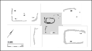
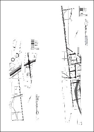
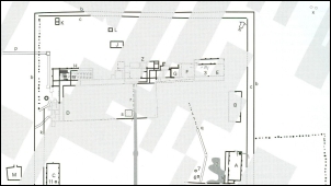
Hoogeloon: villa inside an indigenous settlement
 The
settlement
at Hoogeloon represents an intermediate stage between a real villa and
a villa-like
settlement. The settlement was first established around the beginning
of the
present era, with four contemporaneous traditional farmhouses. At the
end of
the second century AD a villa building was erected in the settlement.
This
building was highly Romanised, and included a heated bathing facility,
a
porticus and its own palisade right from the outset. Recent research
has
revealed a number of new aspects that are not included in the plan
shown here.
A second courtyard containing only a well and a cattle pen was created
outside
the palisade around the main building. Outside this area there were
three
traditional farmhouses. The plan shows many more houses, though they
were
probably not contemporaneous. The villa building was abandoned in the
late
second century, having existed for no more than a hundred years. The
unique
thing about the settlement in Hoogeloon is the combination of a truly
Romanised
villa building and a completely traditional indigenous settlement. The
villa
building was clearly given its own special place in the settlement. It
was
built over part of the old settlement enclosure, allowing the
farmhouses in the
rest of the settlement to remain, and was also oriented in the same way
as the
existing buildings.
The
settlement
at Hoogeloon represents an intermediate stage between a real villa and
a villa-like
settlement. The settlement was first established around the beginning
of the
present era, with four contemporaneous traditional farmhouses. At the
end of
the second century AD a villa building was erected in the settlement.
This
building was highly Romanised, and included a heated bathing facility,
a
porticus and its own palisade right from the outset. Recent research
has
revealed a number of new aspects that are not included in the plan
shown here.
A second courtyard containing only a well and a cattle pen was created
outside
the palisade around the main building. Outside this area there were
three
traditional farmhouses. The plan shows many more houses, though they
were
probably not contemporaneous. The villa building was abandoned in the
late
second century, having existed for no more than a hundred years. The
unique
thing about the settlement in Hoogeloon is the combination of a truly
Romanised
villa building and a completely traditional indigenous settlement. The
villa
building was clearly given its own special place in the settlement. It
was
built over part of the old settlement enclosure, allowing the
farmhouses in the
rest of the settlement to remain, and was also oriented in the same way
as the
existing buildings.
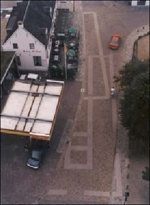
Rijswijk: a villa in the coastal region
 Another
example of this type of settlement can be found in Rijswijk in the
province of
Zuid-Holland. Here, the main building even had wall paintings and walls
built
partly of stone – highly recognisable Romanised features. The auxiliary
buildings were however built according to the old methods and the
settlement
has the appearance of a not entirely Romanised villa. The ground plan
of the
Rijswijk villa (on Tubasingel) has been reconstructed in a local park,
allowing
visitors to trace its position and layout.
Another
example of this type of settlement can be found in Rijswijk in the
province of
Zuid-Holland. Here, the main building even had wall paintings and walls
built
partly of stone – highly recognisable Romanised features. The auxiliary
buildings were however built according to the old methods and the
settlement
has the appearance of a not entirely Romanised villa. The ground plan
of the
Rijswijk villa (on Tubasingel) has been reconstructed in a local park,
allowing
visitors to trace its position and layout.
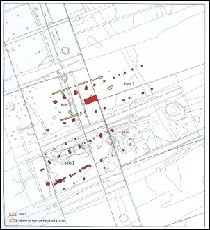
Houten: villae in the river area
Villae or villa-like
buildings also existed in the river area. Small sections of a number of
villae
have been identified. One example is the villa in Houten-Molenzoom.
Here, two
rows of foundation pits – pits filled with rubble that provided
foundations for
wooden posts – have been found, suggesting that a building with a
colonnade
once stood here. Remains of two Late Iron Age buildings have also been
found in
the immediate vicinity, so the spot had been inhabited for a long time.
Even
before the building with the colonnade was erected, another building
nearby was
decorated with wall paintings, remains of which have been found among
the
rubble in the pits. We do not however know what this earlier building
would
have looked like.
 The
ground
plan of another villa in Houten can be seen in the paving on
Burgemeester
Wallerweg in the town centre. Several Late Iron Age or Early Roman
period
features have been found here, but the most interesting are the remains
of a
Roman villa building. Three successive buildings stood on this site in
the
Roman period. The first farm was built somewhere between AD 50 and 75.
It was a
wooden building, only the northern half of which has been excavated.
Between
approximately AD 110 and 120 a second farm was built, again from wood.
In this
case, too, only a small part of the farm has been excavated. The third
building
was built somewhere between AD 150 and 175. It had stone foundations
and a
porticus (colonnade) on the north side. Glazed windows, wall paintings
and
hypocaust heating tell us that this was a luxurious home.
Unfortunately, the
rest of the villa complex has not been excavated, so we do not know
whether
this was a ‘real’ villa or a villa-like settlement, similar to that
found in
Hoogeloon, for example.
The
ground
plan of another villa in Houten can be seen in the paving on
Burgemeester
Wallerweg in the town centre. Several Late Iron Age or Early Roman
period
features have been found here, but the most interesting are the remains
of a
Roman villa building. Three successive buildings stood on this site in
the
Roman period. The first farm was built somewhere between AD 50 and 75.
It was a
wooden building, only the northern half of which has been excavated.
Between
approximately AD 110 and 120 a second farm was built, again from wood.
In this
case, too, only a small part of the farm has been excavated. The third
building
was built somewhere between AD 150 and 175. It had stone foundations
and a
porticus (colonnade) on the north side. Glazed windows, wall paintings
and
hypocaust heating tell us that this was a luxurious home.
Unfortunately, the
rest of the villa complex has not been excavated, so we do not know
whether
this was a ‘real’ villa or a villa-like settlement, similar to that
found in
Hoogeloon, for example.
Country estate or farm?
There were in
fact two types of villa in Italy and the old provinces of the Roman
empire: the villa urbana and the villa rustica. A villa urbana was
inhabited by the owner himself,
though perhaps not always continuously, as he would also have a house
in town.
Although a villa urbana was a farm, it functioned mainly as a
peaceful retreat in the countryside. At a villa rustica, by contrast,
the
emphasis was on farming. It was often inhabited and run by a bailiff or
tenant,
and the owner would have visited only on rare occasions. Excavation
results in
the Netherlands do not allow us to identify the
difference between a villa urbana and a villa rustica. It is therefore
assumed that a villa urbana, where a wealthy owner would spend a
lot of his time, would be more luxurious, while a villa rustica would
have been
more practical. The term villa rustica is therefore use for villae that
were
clearly largely oriented towards farming. Villa urbana is reserved for
very large, luxurious
villae.
A villa as a business
Most of the
villae in the Netherlands were probably villae rusticae. They are
unlikely to
have been very spacious and luxurious, and the entire homestead would
have been
designed with practicality and production in mind. However, it is
assumed that
the owner would have lived there himself, unlike at the original villae
rusticae.
Luxury villa with fine views
 Only
one villa
in the Netherlands is regarded as a villa urbana. It is the ‘Plasmolen’
villa on St.
Jansberg near Mook, to the south of Nijmegen. This large villa, built
around
the beginning of the second century, stood on a specially created
terrace on a
hillside. From its high vantage point,
the villa commanded a magnificent view over the Maas valley and the
surrounding
area. Inside it was decorated with wall paintings. A special heating
system
that had been installed in some rooms supplied heat under the floor and
through
pipes behind the walls. There were also heated baths in the house
itself.
Because the building stood on a hillside there was no room for any
outbuildings. They may well have been at the bottom of the hill, though
none
have been found to date. Plasmolen is regarded as a villa urbana
because of its size and location,
which is still a noticeable feature in the landscape. The villa has
been
partially reconstructed on its original site, on the flat terrace
halfway up
the side of St. Jansberg hill, which is covered in trees nowadays.
Only
one villa
in the Netherlands is regarded as a villa urbana. It is the ‘Plasmolen’
villa on St.
Jansberg near Mook, to the south of Nijmegen. This large villa, built
around
the beginning of the second century, stood on a specially created
terrace on a
hillside. From its high vantage point,
the villa commanded a magnificent view over the Maas valley and the
surrounding
area. Inside it was decorated with wall paintings. A special heating
system
that had been installed in some rooms supplied heat under the floor and
through
pipes behind the walls. There were also heated baths in the house
itself.
Because the building stood on a hillside there was no room for any
outbuildings. They may well have been at the bottom of the hill, though
none
have been found to date. Plasmolen is regarded as a villa urbana
because of its size and location,
which is still a noticeable feature in the landscape. The villa has
been
partially reconstructed on its original site, on the flat terrace
halfway up
the side of St. Jansberg hill, which is covered in trees nowadays.
Villae in
the Netherlands
Early investigations
 Most
of our
information about Roman villae in the Netherlands comes from the south
of
Limburg. Many Roman villae have been excavated there, largely in the
19th and
early 20th centuries. Since archaeology was not practised according to
the same
standards then as it is today, our knowledge of these villae is
limited,
however. During excavations, the focus was largely on the architectural
and art
historical aspects of the buildings. Often, only one building would be
excavated, whereas villae consisted of several buildings. One exception
was the
villa at Bocholtz (also known as Vlengendaal), which was excavated
around 1912.
There, two outbuildings were also excavated.
Most
of our
information about Roman villae in the Netherlands comes from the south
of
Limburg. Many Roman villae have been excavated there, largely in the
19th and
early 20th centuries. Since archaeology was not practised according to
the same
standards then as it is today, our knowledge of these villae is
limited,
however. During excavations, the focus was largely on the architectural
and art
historical aspects of the buildings. Often, only one building would be
excavated, whereas villae consisted of several buildings. One exception
was the
villa at Bocholtz (also known as Vlengendaal), which was excavated
around 1912.
There, two outbuildings were also excavated.
Southern Netherlands
 It
was not
until relatively recently that two villae were virtually completely
excavated:
Voerendaal-Ten Hove and Kerkrade-Holzkuil in the southern Limburg loess
area.
An almost complete excavation of the villa in Neerharen-Rekem, just
over the
Belgian border, has taught us more about the homestead itself and the
auxiliary
buildings. Analysis of seeds and pollen has added to our knowledge of
the
agricultural villa economy. Unfortunately, we know little about the
Dutch
villae further to the north. At Maasbracht, in the Maas valley,
however, the
main building of a villa has been excavated, giving us more information
about
villae in this area. The Maas valley was probably full of villae, but
very few
have been excavated.
It
was not
until relatively recently that two villae were virtually completely
excavated:
Voerendaal-Ten Hove and Kerkrade-Holzkuil in the southern Limburg loess
area.
An almost complete excavation of the villa in Neerharen-Rekem, just
over the
Belgian border, has taught us more about the homestead itself and the
auxiliary
buildings. Analysis of seeds and pollen has added to our knowledge of
the
agricultural villa economy. Unfortunately, we know little about the
Dutch
villae further to the north. At Maasbracht, in the Maas valley,
however, the
main building of a villa has been excavated, giving us more information
about
villae in this area. The Maas valley was probably full of villae, but
very few
have been excavated.
 |
 |
The river area
Things are
much the same in the river area. Surface finds suggest that there were
a
considerable number of villae there. However, only a few have been
extensively
excavated: of the 24 (probable) villae in the area, only nine have been
partially excavated. The single almost completely excavated villa or
villa-like
settlement in the river area is Druten-Klepperhei, where a number of
wooden
buildings and buildings with stone foundations have been found. A
wooden house
surrounded by a wooden porticus stood at the site of what is suspected
to have
been the main building. A stone cellar and bath house were also found
there,
along with many fragments of wall paintings. The main building was
probably
erected in the late first century, and abandoned in the second century,
having
existed for barely a hundred years. The rest of the settlement remained
for
longer, however. The excavation data from the villa at
Druten-Klepperhei are
being re-examined. It has been found that our old image and the ground
plan of
this villa probably require some adjustment, though exactly what kind
of
adjustment is not yet clear.
What did a villa look like?
Studies – both old and new – of villae in the Netherlands and just over the border have revealed a number of general features that are common to Dutch villae. A villa was an enclosed homestead, which included a main building with auxiliary buildings, a well or water storage facility and perhaps a pond. The site was enclosed by a ditch, hedge, fence, palisade or walls. In some cases, a shrine has been found at or near the homestead. The main building and several auxiliary buildings would usually have had stone foundations. They stood in a fairly ordered pattern around an open area in the centre of the homestead. Villae where the buildings were dispersed over the site are referred to by the German name ‘Streuhof’. On an ‘Axialhof’ the buildings were much more neatly arranged, with the main building on the main axis, and the majority of the auxiliary buildings on the two perpendicular axes, creating a central courtyard. Most of the villae excavated so far in the Netherlands have been of the ‘Axialhof’ type.
Auxiliary buildings
Little is
generally known about the function of the auxiliary buildings. They are
likely
to have been used for storage, housing animals, workshops and possibly
staff
accommodation. Sometimes a separate bath house was built, though
bathrooms were
often simply added to the main buildings. It was not uncommon for
several of
the outbuildings to be built partially of stone.
The main building
 The
main
building or house generally consisted of a rectangular core, to which a
porticus (colonnade) and corner pavilions were often added. The house
would be
fairly symmetrical. Inside, some walls would be decorated with wall
paintings.
A number of rooms would be heated by means of hot air flowing under the
floor
and through the wall cavity (hypocaust heating). Many villae lost their
original symmetrical form as they were repeatedly expanded.
The
main
building or house generally consisted of a rectangular core, to which a
porticus (colonnade) and corner pavilions were often added. The house
would be
fairly symmetrical. Inside, some walls would be decorated with wall
paintings.
A number of rooms would be heated by means of hot air flowing under the
floor
and through the wall cavity (hypocaust heating). Many villae lost their
original symmetrical form as they were repeatedly expanded.
Visiting a Roman villa?
 A
reconstruction of a Dutch villa in the municipality of Kerkrade is open
to
visitors. At Kaalheide, on the Krichelberg plateau (currently on the
edge of a
residential area), the foundations of the main building of a villa have
been
recreated in a local park, clearly revealing the ground plan of the
building.
The walls had stone foundations that protruded above the ground,
probably
supporting wattle and daub walls.
A
reconstruction of a Dutch villa in the municipality of Kerkrade is open
to
visitors. At Kaalheide, on the Krichelberg plateau (currently on the
edge of a
residential area), the foundations of the main building of a villa have
been
recreated in a local park, clearly revealing the ground plan of the
building.
The walls had stone foundations that protruded above the ground,
probably
supporting wattle and daub walls.
Work and private life
A villa
traditionally consisted of two parts: the pars urbana (also known as
the pars domestica) and
the pars rustica. The pars urbana was the residential part of the
villa.
The pars rustica was the commercial part, where the work – usually
farming –
was done. This distinction is very difficult to make in Dutch villae.
Often no
more than a few buildings have been excavated at each site, so it is
difficult
to determine what purpose they would have served. Furthermore, the two
sides of
villa life were often not entirely separate. The main, residential,
building
might also have contained rooms that would be used for commercial
purposes, for
example.
The large villa at Voerendaal
 One
of the
most comprehensively excavated villae in the Netherlands is in
Voerendaal,
southern Limburg. Here, it is possible to distinguish between the pars
urbana and the pars rustica, although living
and working spaces do seem to have been combined here and there. The
pars
urbana consists of several separate buildings connected by a colonnade:
the
house in the north of the site, the horreum (granary) in the northwest,
the
bath house to the south of the horreum and, finally, the walled garden,
which
also formed a clear boundary between the pars domestica and pars
rustica. On
the northern side of the house, in the back yard, there were probably
two
shrines that can also be regarded as part of the pars domestica.
Another
slightly larger building whose function is unknown also stood here. The
location of the horreum – strongly associated with the commercial side
of the
villa – in the pars domestica can be explained by the fact that the
fruits of
an entire year’s labour would be stored there. The prosperity of the
villa
depended almost entirely on these stocks, so it was important that they
were
not accessible to all and sundry. The other buildings and structures at
the
front can be regarded as part of the pars rustica. The animal stalls or
barns
were probably on the eastern side. The staff of the villa might have
lived in
their own separate quarters close to the large house. In the southeast
corner
of the complex there was a building where grain was processed. The
smithy
probably stood in the southwest corner.
One
of the
most comprehensively excavated villae in the Netherlands is in
Voerendaal,
southern Limburg. Here, it is possible to distinguish between the pars
urbana and the pars rustica, although living
and working spaces do seem to have been combined here and there. The
pars
urbana consists of several separate buildings connected by a colonnade:
the
house in the north of the site, the horreum (granary) in the northwest,
the
bath house to the south of the horreum and, finally, the walled garden,
which
also formed a clear boundary between the pars domestica and pars
rustica. On
the northern side of the house, in the back yard, there were probably
two
shrines that can also be regarded as part of the pars domestica.
Another
slightly larger building whose function is unknown also stood here. The
location of the horreum – strongly associated with the commercial side
of the
villa – in the pars domestica can be explained by the fact that the
fruits of
an entire year’s labour would be stored there. The prosperity of the
villa
depended almost entirely on these stocks, so it was important that they
were
not accessible to all and sundry. The other buildings and structures at
the
front can be regarded as part of the pars rustica. The animal stalls or
barns
were probably on the eastern side. The staff of the villa might have
lived in
their own separate quarters close to the large house. In the southeast
corner
of the complex there was a building where grain was processed. The
smithy
probably stood in the southwest corner.
Central heating
 Most
villae in
the Netherlands were not particularly luxurious. However, one luxury
people did
permit themselves was central heating. Traditional farmhouses were
heated by a
central hearth, which was also used for cooking. The animals in the
adjacent
stalls also provided some heat. In a villa, the rooms were heated by
the
hypocaust method. Warm air from a furnace room flowed through a hollow
space
under the floor (the hypocaust), rising from there through the wall
cavity. The
cavity was created using square or rectangular tubes (tubuli). Usually
only a
few rooms would be heated in this way. It is generally assumed that
these were
the living quarters or reception rooms. Bathrooms were usually also
heated.
Most
villae in
the Netherlands were not particularly luxurious. However, one luxury
people did
permit themselves was central heating. Traditional farmhouses were
heated by a
central hearth, which was also used for cooking. The animals in the
adjacent
stalls also provided some heat. In a villa, the rooms were heated by
the
hypocaust method. Warm air from a furnace room flowed through a hollow
space
under the floor (the hypocaust), rising from there through the wall
cavity. The
cavity was created using square or rectangular tubes (tubuli). Usually
only a
few rooms would be heated in this way. It is generally assumed that
these were
the living quarters or reception rooms. Bathrooms were usually also
heated.
Bath house
The bathing facility
in a villa was usually a smaller version of a public bath house. It
generally
consisted of cold, lukewarm and hot baths, a changing room and a
furnace room.
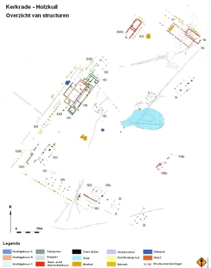
In Kerkrade-Holzkuil the bathing facility was found to be in a good
state of
preservation. Beside the furnace room was the hot water bath, and
probably also
a dining room or reception room, which would also be warmed by the heat
from
the hot bath. There was also an unheated room (probably the changing
room) and
a cold water bath. The bath house was surrounded by a corridor with a
door to
the outside, so that people from outside (probably staff) could use the
facilities without having to pass through the main building.
 |
 |
Wall paintings
The décor in a
Dutch villa was probably nothing special, though interior wall
paintings would
have clearly distinguished it from an indigenous farmhouse. Such
paintings were
otherwise found only in military or public buildings, or in town. Those
found
in the countryside were probably fairly simple and abstract. The walls
were
often divided into several framed panels of different colours. Ceilings
and
walls were sometimes decorated with a flower motif or rosettes. Many
fragments
of this kind of decoration have been found at the proto-villa in
Rijswijk. Few
remains of paintings depicting animals or people have ever been found,
except
in the villae at Kerkrade-Holzkuil and Maasbracht, where a number of
fragments
of wall paintings depicting people have been found. One of the people
depicted
at Maasbracht is shown with a writing tablet (tabella). The owner of
the villa
might have commissioned a portrait of himself to show that he was a
civilised
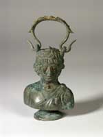
man with the ability to read and write.
 |
 |
 |
Mosaics
Mosaics, generally so common in the Roman world, were rare in the Roman Netherlands. We know from reports of 19th-century excavations that some mosaics have been found, but none has been preserved. Individual mosaic pieces among the finds at several villa sites suggest that there were probably mosaics there, but we do not know what they would have looked like.
The importance of a good location
 The
variety of
villae and villa-like settlements probably derives from the different
types of
soil and cultural traditions, and their geographical position within
the Roman empire. By far the majority of Dutch villae
were in the south of the present-day province of Limburg (represented
by orange
dots on the map). This was due primarily to the fertile soil found
there, which
would ensure the best possible yield. The loamy loess soil in the south
of
Limburg was fertile and easy to work. However, the locations of villae
suggest
that stockbreeding also played a role in the villa economy. Less
fertile ground
was fine for grazing cattle, and the wetter soils of a brook valley or
river
meadow provided perfect pasture. There were also slight differences in
fertility in the loess soils themselves. Villae often stood more or
less on the
dividing line between fertile and less fertile land, on a plateau or
slope down
towards a stream or river. This allowed crops to be grown on the dry,
fertile
soil, while cattle would graze the lower-lying wetter land. Besides the
favourable soil conditions at such a location, the aesthetics of the
landscape
might also have been a consideration. If a villa was built on a higher
spot, it
would be visible for miles around, certainly with its orange roof
tiles. And of
course the inhabitants of the villa would have a fantastic view.
The
variety of
villae and villa-like settlements probably derives from the different
types of
soil and cultural traditions, and their geographical position within
the Roman empire. By far the majority of Dutch villae
were in the south of the present-day province of Limburg (represented
by orange
dots on the map). This was due primarily to the fertile soil found
there, which
would ensure the best possible yield. The loamy loess soil in the south
of
Limburg was fertile and easy to work. However, the locations of villae
suggest
that stockbreeding also played a role in the villa economy. Less
fertile ground
was fine for grazing cattle, and the wetter soils of a brook valley or
river
meadow provided perfect pasture. There were also slight differences in
fertility in the loess soils themselves. Villae often stood more or
less on the
dividing line between fertile and less fertile land, on a plateau or
slope down
towards a stream or river. This allowed crops to be grown on the dry,
fertile
soil, while cattle would graze the lower-lying wetter land. Besides the
favourable soil conditions at such a location, the aesthetics of the
landscape
might also have been a consideration. If a villa was built on a higher
spot, it
would be visible for miles around, certainly with its orange roof
tiles. And of
course the inhabitants of the villa would have a fantastic view.
Infrastructure and markets
It was not
only the fertile loess soils that ensured the villa economy in southern
Limburg
flourished. Thanks to the road and water infrastructure, the loess area
and
Maas valley, in particular, were able to develop rapidly. There were
markets
close at hand, so produce could be sold quickly and at little cost.
Towns such
as Heerlen, Maastricht, Tongeren (Belgium) and Aachen (Germany) needed
a lot of
food. Goods could also be transported quickly and cheaply along the
Maas to the
north, to supply the large numbers of soldiers stationed on the border.
The
major road between the Roman town of Boulogne-sur-Mer (France) and the
provincial capital in Cologne (Germany) ran right through this area,
bringing
plenty of trade and traffic. The villae in the Maas valley were ideally
located
for the Maas, guaranteeing them good connections to both the north and
the
south. A major road also ran along the left bank of the Maas, from
Nijmegen to
Tongeren. There were probably many villae along this road, too.
Indigenous settlements among the villae
 Indigenous
settlements continued to exist, too. In Kerkrade, an indigenous
settlement and
several villae have been found within a three kilometre radius. The
settlement
and villae were probably occupied at the same time. We do not know what
kind of
relationship existed between indigenous settlements and villae. The
inhabitants
of the settlement may have worked for the villa owner, but it is
equally likely
that settlements and villae led separate existences and had very little
contact.
Indigenous
settlements continued to exist, too. In Kerkrade, an indigenous
settlement and
several villae have been found within a three kilometre radius. The
settlement
and villae were probably occupied at the same time. We do not know what
kind of
relationship existed between indigenous settlements and villae. The
inhabitants
of the settlement may have worked for the villa owner, but it is
equally likely
that settlements and villae led separate existences and had very little
contact.
Germania Inferior or Gallia Belgica?
Although the
villae on the loess soils of southern Limburg have played an important
role in
Dutch villa research, we are not entirely certain that they were
actually in
the province of Germania Inferior, since we do not know the precise
position of
its southern border. The Dutch river area and a large part of the Dutch
coastal
region did at any rate belong to Germania Inferior. It is possible that
the
southern Limburg loess area was part of the province of Gallia Belgica,
which
lay largely in present-day Belgium and northern France. This province
was
placed under civilian administration at quite an early stage, and the
army’s
presence was not quite as pronounced there as it was in Germania
Inferior.
Given that it was a military province until the end of the first
century, the
villae in Germania Inferior may have emerged and developed differently
from
those in the neighbouring province of Gallia Belgica. However, it is
not clear
whether the administration or the presence of the army had such an
impact on
civilian life.
Cattle farmers on sandy soils
 Villa-like
settlements (represented by yellow dots on the map) appear to occur
mainly on
the less fertile sandy soils and along the coast. The sandy soils
between the
rivers Maas, Demer and Scheldt were in a much less favourable
geographical
position in the province. Farming was less profitable there, as the
soil was
less fertile than in southern Limburg. It is therefore assumed that
stockbreeding was more important in this region. Breeding cattle
probably
brought with it an entirely different way of life, and a large-scale
farm like
a villa might not have suited the way people lived there.
Villa-like
settlements (represented by yellow dots on the map) appear to occur
mainly on
the less fertile sandy soils and along the coast. The sandy soils
between the
rivers Maas, Demer and Scheldt were in a much less favourable
geographical
position in the province. Farming was less profitable there, as the
soil was
less fertile than in southern Limburg. It is therefore assumed that
stockbreeding was more important in this region. Breeding cattle
probably
brought with it an entirely different way of life, and a large-scale
farm like
a villa might not have suited the way people lived there.
Little contact with the Romans
The sandy area was also somewhat distanced from events during the Roman period. The military-controlled border area was quite far away, and there were no large towns in the region. There were probably no major thoroughfares either. As a result, the inhabitants of the region were less likely to come into contact with Roman culture. Developments in the sandy area therefore differed from those in the loess area of southern Limburg. The villa-like settlement in Hoogeloon, for example, focused mainly on stockbreeding for its subsistence. However, observations of Roman stone buildings and various surface finds suggest that there are more villae (or villa-like settlements) in the sandy soils of Brabant than have been discovered to date.
River area: close to the border
The river area
was a formidable competitor of the sandy area when it came to
stockbreeding.
The Batavians, who lived among the interwoven rivers flowing through
the
Netherlands, were closer to the military sites and therefore also to
the main
markets for the sale of cattle and horses. This region was heavily
influenced
by the military sites along the empire’s border. The Batavians quickly
became
Romanised after the Batavian revolt had been defeated in AD 69/70.
There were
probably many villae or villa-like settlements in this region, though
only a few
have been excavated.
Not entirely Romanised
 The
only
virtually completely excavated villa or villa-like settlement is in
Druten.
Though this settlement had a Romanised main building, the other
buildings
appear to have been traditional farmhouses. The complex existed for
only a
hundred years or so before it was abandoned. The few remains of other
villae
suggest that they too were not entirely Romanised, at least not in the
way that
the villae in southern Limburg were. Despite the proximity of Roman
culture at nearby military sites, there were still a lot of indigenous
settlements in the region, several of which have been excavated.
The
only
virtually completely excavated villa or villa-like settlement is in
Druten.
Though this settlement had a Romanised main building, the other
buildings
appear to have been traditional farmhouses. The complex existed for
only a
hundred years or so before it was abandoned. The few remains of other
villae
suggest that they too were not entirely Romanised, at least not in the
way that
the villae in southern Limburg were. Despite the proximity of Roman
culture at nearby military sites, there were still a lot of indigenous
settlements in the region, several of which have been excavated.
Where are the villae in the coastal region?
Little is known about the final region, along the coast. It would seem that there were no fully Romanised villae there, though a number of villa-like settlements have been excavated. They were probably concentrated near the Roman town in Voorburg and around the Maas and Scheldt estuaries. The Maas estuary was an economically important area, and a number of stone buildings were erected there in the second half of the second century. No more than a few fragments of them have ever been found, so we do not know whether they were villae. Around the same time, a number of wooden buildings clearly inspired by Roman architecture appeared. We also have little information about these buildings, though it is quite possible that both the stone and wooden buildings were the remains of villae or villa-like settlements along the Maas estuary. The Scheldt estuary was probably also important. Unfortunately, however, the sea has eroded away much of the land that was there in the Roman period, though we do know that the estuary was an important point of departure for ships sailing to Britannia. Many merchants dedicated altars to the goddess Nehalennia here, in the hope that she would ensure them safe passage across the stormy North Sea. The presence of this important trade route will have encouraged occupation in the region. However, since the soil (mainly wet peat bogs) was not very suitable for farming, it is not clear whether there would have been any villae there.
Rijswijk: villa-like settlement
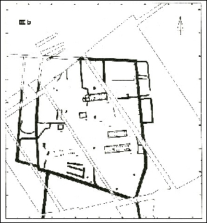 The
villa-like
settlement in Rijswijk – where a small indigenous settlement developed
into a villa-like
complex – is a good example of what a villa or villa-like settlement in
the
coastal region might have looked like. It all began around the
beginning of the
present era with a single small farm. The settlement soon grew to three
contemporaneous farmhouses with outbuildings. The northeastern
farmstead – the
site of the original farm – developed differently from the others.
There, a
house with stone foundations was built in the early third century. None
of the
other houses in the settlement had stone foundations. The house had
other Roman
features, too, including a bathroom, wall paintings and hypocaust
heating. The
other buildings and the layout of the settlement changed little. All
the
farmsteads had their own commercial operation associated with
stockbreeding or
arable farming. This suggests that, though the settlement did not have
the
appearance of a villa, it nevertheless operated like one. The
settlement site
in Rijswijk was divided up by ditches in the mid-second century,
creating three
separate farmsteads. The entire settlement was also surrounded by
ditches,
which were connected to a much larger system of ditches. The parcels of
land
(arable land and pasture) created by this ditch system covered some 2
to 5 ha.
Together, the ditches created a parcelling system based on standard
dimensions.
We now know that an indigenous settlement further to the south, in
Midden-Delfland, was part of the same parcelling system.
The
villa-like
settlement in Rijswijk – where a small indigenous settlement developed
into a villa-like
complex – is a good example of what a villa or villa-like settlement in
the
coastal region might have looked like. It all began around the
beginning of the
present era with a single small farm. The settlement soon grew to three
contemporaneous farmhouses with outbuildings. The northeastern
farmstead – the
site of the original farm – developed differently from the others.
There, a
house with stone foundations was built in the early third century. None
of the
other houses in the settlement had stone foundations. The house had
other Roman
features, too, including a bathroom, wall paintings and hypocaust
heating. The
other buildings and the layout of the settlement changed little. All
the
farmsteads had their own commercial operation associated with
stockbreeding or
arable farming. This suggests that, though the settlement did not have
the
appearance of a villa, it nevertheless operated like one. The
settlement site
in Rijswijk was divided up by ditches in the mid-second century,
creating three
separate farmsteads. The entire settlement was also surrounded by
ditches,
which were connected to a much larger system of ditches. The parcels of
land
(arable land and pasture) created by this ditch system covered some 2
to 5 ha.
Together, the ditches created a parcelling system based on standard
dimensions.
We now know that an indigenous settlement further to the south, in
Midden-Delfland, was part of the same parcelling system.
Katwijk: villa-like settlement on the border
There was
probably also a villa-like settlement in Katwijk, very close to the
border of
the Roman empire. Here, finds of roof tiles, wall
paintings and heating pipes suggest that a special building stood on
this site,
built in the first phase of the settlement and surviving to the end.
Though the
villa-like settlement in Katwijk was probably indigenous, it appears to
have
had strong ties to the nearby military site in Valkenburg. This is
substantiated not only by finds, but also by the fact that the
settlement was
founded and abandoned at almost exactly the same time as the military
camp at
Valkenburg (AD 40-200). The settlement in Katwijk thus clearly differs
from
that in Rijswijk.
Farming constituted the main economic basis of villae in the Netherlands, although stone quarrying, iron ore smelting and brick and tile production would also have been possible sources of income.
Transformation of arable farming
Farmers mainly grew cereal crops, particularly on the fertile loess soils. They had already done so in the Iron Age, albeit on a subsistence basis. In the Roman period demand for agricultural produce grew steadily, and farming had to become more intensive to meet the demand. This was achieved using new techniques, such as fertilisation, harrowing and improved ploughing methods. Crop rotation was also introduced, allowing poorer soils, which in prehistory had to be left fallow for long periods, to be used for longer consecutive periods. The harvester developed in Gallia, which speeded up the harvest, might also have been used in some regions.
Specialisation
 The
villa
economy on the loess soils probably specialised in growing spelt, which
has
been found at the villa at Voerendaal in an analysis of burnt grains
and
pollen. Although other types of grain and crops have been found, they
were
probably grown only for use at the villa itself. Spelt, and also common
wheat,
have been found in excavations of large granaries at several military
camps and
in towns. They were probably the most important staple crops.
The
villa
economy on the loess soils probably specialised in growing spelt, which
has
been found at the villa at Voerendaal in an analysis of burnt grains
and
pollen. Although other types of grain and crops have been found, they
were
probably grown only for use at the villa itself. Spelt, and also common
wheat,
have been found in excavations of large granaries at several military
camps and
in towns. They were probably the most important staple crops.
Fertile land is priceless
It has been
calculated that seven villae in the ‘Heerlen basin’, where the
Voerendaal-Ten
Hove villa is situated, would produce a surplus that could feed an
extra 2800
people (besides the villa inhabitants and staff). The less fertile
farmland in
the loess area would have produced a smaller surplus. There, seven
villae could
have fed up to 861 extra people. Loess soil degraded as a result of
farming and
slope erosion, gradually making it less suitable for growing cereals
and other
crops. It is therefore likely that the production of the villae
gradually
shifted to stockbreeding in places where the soil had declined in
fertility.
Stockbreeding
had always played a greater role on the sandy soils of Brabant and in
the river
area. Although small buildings for storing grain have been found at
virtually
all villa-like settlements – which appear to be most common in
stockbreeding
areas – stockbreeding would have been their main source of income.
Cattle were
kept in the villa-like settlements in traditional farmhouses combining
living
quarters and animal stalls under one roof. It is not entirely clear
whether
cattle would also have been kept in the main building itself. At the
villa in
Hoogeloon there is strong evidence that the settlement revolved around
stockbreeding. The position of the cattle pen, within the perimeter
fence right
beside the main building, indicates the importance of cattle to the
settlement.
The presence of various combined farmhouses at the villa-like
settlements at
Rijswijk-De Bult and Oss-Westerveld suggests that they too lived from
stockbreeding.
Stone quarrying
Stone suitable
for building is found in southern Limburg, though it is not as good as
the
stone from the German Rhineland or Belgian Ardennes. The Limburg stone
has been
found at several villae in the region. Interestingly, it was rarely
used
outside southern Limburg, where people seemed to prefer better quality
stone
from further afield. The quarries in southern Limburg, which mainly
produced
limestone, were probably run by villae, however. One possible example
of such a
villa is Kerkrade-Holzkuil, which was close to a quarry known to have
been
worked in the Roman period. Half-finished sections of pillar made from
stone
quarried there have been found in a well at the villa. The villa
residents at
any rate used the stone from the quarry for their own purposes. There
is no
evidence that the quarry was exploited commercially, so we do not know
whether
this would have been the villa’s main source of income. We do however
know that
arable farming was an important economic activity there.
Production of
brick and tile
 It
is quite
possible that there were also villae in the Maas valley or river area
that produced
their own bricks or roof tiles. The river clay and the clay found in
the many
brook valleys there was ideal for the purpose. Brick ovens existed
along the
Maas well into the twentieth century. Stamps on roof tiles tell us who
made
them, so we know that the majority of roof tiles found in the
Netherlands were
produced by the Roman army. However, roof tiles with other stamps have
also
been found in villae. Some of them seem to have originated in Belgium,
where
they were made by civilian producers. However, no tile works that
produced the
tiles found has ever been excavated there, and it is quite possible
that they
were actually made in the Netherlands.
It
is quite
possible that there were also villae in the Maas valley or river area
that produced
their own bricks or roof tiles. The river clay and the clay found in
the many
brook valleys there was ideal for the purpose. Brick ovens existed
along the
Maas well into the twentieth century. Stamps on roof tiles tell us who
made
them, so we know that the majority of roof tiles found in the
Netherlands were
produced by the Roman army. However, roof tiles with other stamps have
also
been found in villae. Some of them seem to have originated in Belgium,
where
they were made by civilian producers. However, no tile works that
produced the
tiles found has ever been excavated there, and it is quite possible
that they
were actually made in the Netherlands.
Iron production
Metal slag has
been found at most settlements and villae, evidence of a smithy at the
site.
Most of them will not have been very large, and would probably have
made and
repaired things for the villa itself and perhaps for people in the
immediate
vicinity. Nevertheless, the possibility of iron production cannot be
entirely
discounted. In several areas of the Netherlands there would have been
enough
bog iron or iron ore for some level of iron production to exist.
However, no
smelting furnace has ever been found at a villa complex.
Possible
shrines have been excavated at several villae. Figurines of gods and
goddesses
are also regularly found during excavations, indicating that cults
played a
role in the daily lives of the inhabitants. It is difficult to
ascertain which
gods were worshipped at the shrines found, though it would appear that
they
included both Roman and indigenous gods.
Secundio of Voerendaal
 Two
small
buildings that are believed to have been shrines have been found in the
back
yard of the Voerendaal villa. Stronger evidence has indeed been found
in
association with one of the buildings, in the form of unusual
earthenware pots
with names scratched on them. They include the forename of a number of
people:
someone known as Secundio, another whose name begins with Sever(…), a
name
beginning with Cu(…). A fourth inscription is difficult to decipher. It
could
be that it included the name of a goddess, which has since become
illegible.
The name ends in ‘…na’. The following sentence can be reconstructed
from the
remaining letters: ‘Iu(cundus, -lianus, -lius) hath dedicated this to
(the
goddess) …na’.
Two
small
buildings that are believed to have been shrines have been found in the
back
yard of the Voerendaal villa. Stronger evidence has indeed been found
in
association with one of the buildings, in the form of unusual
earthenware pots
with names scratched on them. They include the forename of a number of
people:
someone known as Secundio, another whose name begins with Sever(…), a
name
beginning with Cu(…). A fourth inscription is difficult to decipher. It
could
be that it included the name of a goddess, which has since become
illegible.
The name ends in ‘…na’. The following sentence can be reconstructed
from the
remaining letters: ‘Iu(cundus, -lianus, -lius) hath dedicated this to
(the
goddess) …na’.
Open-air shrines
 Small
shrines
have also been found at the villa-like settlements at Hoogeloon and
Oss-Westerveld. These open-air shrines, with no building around them,
were already
in use before the Roman period. In Hoogeloon the shrine was surrounded
by a
ditch with a row of posts and possibly a (sacred?) tree.
Small
shrines
have also been found at the villa-like settlements at Hoogeloon and
Oss-Westerveld. These open-air shrines, with no building around them,
were already
in use before the Roman period. In Hoogeloon the shrine was surrounded
by a
ditch with a row of posts and possibly a (sacred?) tree.
Veterans and indigenous elite
It was originally thought that most villae were established by Roman colonists or army veterans. However, recent excavations have revealed that many villae were in fact owned by indigenous people. This would at any rate appear to have been the case with the indigenous settlements that were later converted to villae, such as Voerendaal-Ten Hove, Neerharen-Rekem and the villa-like settlements at Hoogeloon and Rijswijk. We do not know for certain whether the newly established villae also had indigenous owners, though it is believed that most of these villae will have been founded by indigenous people who had achieved a high status within the new society. They would have had enough money to afford to build a villa.
Local officials
from Xanten
 Bronze
plaques with inscriptions including names have been found in one of the
villae in southern Li.mburg (Houthen-Sint Gerlach). The first indicates
that a certain Julius gave one Marcus Vitalinius, a high-ranking
official and one of the ‘mayors’ of Colonia Ulpia Traiana (the large
town in Xanten, Germany), an assurance of friendship. On the back of
the plaque is a more recent inscription in which the tribe of Catualium
pays honour to Titus Tertinius, an ex-official (one of the law
enforcers) from Xanten. The same name also appears on a second plaque,
which also honours Titus Tertinius, stating that he was also a ‘council
member’ and ‘mayor’. The inscription on the third plaque is very
incomplete, although one might discern the name Titus Tertinius here,
too. These bronze plaques suggest that villae were owned by wealthy
local officials. The villa is more than 100 kilometres from Xanten, so
the officials would probably not have lived there all year round. A
bailiff or tenant will have been responsible for the actual running of
the villa.
Bronze
plaques with inscriptions including names have been found in one of the
villae in southern Li.mburg (Houthen-Sint Gerlach). The first indicates
that a certain Julius gave one Marcus Vitalinius, a high-ranking
official and one of the ‘mayors’ of Colonia Ulpia Traiana (the large
town in Xanten, Germany), an assurance of friendship. On the back of
the plaque is a more recent inscription in which the tribe of Catualium
pays honour to Titus Tertinius, an ex-official (one of the law
enforcers) from Xanten. The same name also appears on a second plaque,
which also honours Titus Tertinius, stating that he was also a ‘council
member’ and ‘mayor’. The inscription on the third plaque is very
incomplete, although one might discern the name Titus Tertinius here,
too. These bronze plaques suggest that villae were owned by wealthy
local officials. The villa is more than 100 kilometres from Xanten, so
the officials would probably not have lived there all year round. A
bailiff or tenant will have been responsible for the actual running of
the villa.
Indigenous settlements
Before the
Romans came, people lived in rectangular farmhouses that combined both
living
quarters and animal stalls. Cattle would be housed in one half of the
house,
while the family occupied the other half. A settlement would generally
consist
of no more than three or four contemporaneous farmhouses with a number
of
outbuildings, granaries and wells. But farms often stood alone, too.
Sometimes
a ditch would be dug around a settlement or around individual
farmsteads. Such
small settlements continued to dominate in the countryside throughout
the Roman
period. Finds made there provide incontrovertible evidence that they
were
situated within the Roman empire, however.
New implements
During the
course of the second century almost the entire population switched from
their
old familiar handmade pots to the thrown pots introduced by the Romans.
Other
find material also suggests that indigenous people no longer made
everything
themselves, and that they adopted more and more objects brought by the
Romans.
The Batavian revolt in AD 69/70 was a turning point. After the
rebellion had
been put down, the population seems to have submitted to Roman rule,
and the
‘Romanisation’ of settlements and objects really took hold.
Romanisation: everyone in their own time
Romanisation
was clearly a matter of choice for the local population. Some people
adopted
more Roman ways than others. Indigenous settlements have therefore been
found
alongside almost completely Romanised villae. The degree of
Romanisation
depended, among other things, on the economic potential of the various
regions.
Southern Limburg, for example, was exceptionally fertile, and farming
flourished there. This tied in seamlessly with Roman culture, which had
always
been strongly geared towards arable farming. The sandy soils, wet
peatlands and
river meadows in the rest of the country were more suitable for
stockbreeding.
This was economically less interesting, so occupation developed less
rapidly in
those areas. Finally, cultural differences between the Dutch regions
will also
have created differences in the development of and adaptation to Roman
culture.
Thus, while ‘real’ Roman villae were able to develop in southern
Limburg, the
most important family in a settlement on the sandy soils of Brabant or
in the
coastal region will have sought to distinguish itself with nothing more
than a
Romanesque colonnade. Such settlements are therefore referred to as
villa-like
settlements.
Roman villae
A Roman villa
(villae in the plural) was a form of rural enterprise whose layout and
style
included elements of Roman architecture and culture. It was a complex
with a
main building and auxiliary buildings. A villa produced a surplus that
could be
sold in the towns or to the army. Sometimes the owner would live at the
villa,
while others would be run by a bailiff or tenant. Most villae were
large farms,
though some ran quarries or tile works. A villa consisted of an
enclosed
homestead which included a main building and several auxiliary
buildings. The
main building, and often also several outbuildings, had foundations
made fully
or partially of stone, supporting wattle and daub walls. This clearly
distinguished
them from the indigenous building tradition, which used only wattle and
daub.
The buildings stood in a more or less ordered fashion around a central
yard,
where there would normally be a well, and sometimes also a pond or
water
storage facility. The main building would usually be symmetrical. Most
Dutch
villae feature a colonnade on the front of the building, with two
square rooms
at the corners. The interior walls would be decorated with paintings.
One or
more rooms, including bathrooms in some cases, would be heated by means
of a
hypocaust, which drew warm air through the floor and wall cavities.
Since
villae were continually being expanded, their original symmetrical
design was
often lost.
From indigenous settlement to Roman villa
Both the ‘real’
villae and the villa-like settlements in the Netherlands probably arose
out of
indigenous settlements. They would have been the slightly larger
settlements
consisting of more than the usual three or four farmsteads. Several
such
settlements include one house that was clearly more important than the
rest.
Archaeologists have found special items that suggest that the occupant
of such
a house would have been largely responsible for contacts with the
Romans.  At
the end of the first century many of these main buildings were adapted
to the
Roman style, as the occupants decided to adopt more Roman customs. Some
owners
could afford a colonnade and a tiled roof. Meanwhile, the rest of the
settlement would barely change, if at all. These villa-like settlements
were situated
on the less fertile sandy soils and in the wet peat and clay areas
along the
coast. Examples of such settlements have been found in Rijswijk-De
Bult,
Oss-Westerveld and Hoogeloon. A few indigenous settlements in southern
Limburg
were given a radical makeover, however. All the old houses were
demolished to
be replaced by a main building with separate outbuildings: a real Roman
villa.
These villae were probably concentrated in the south of Limburg and the
Maas
valley. Examples of settlements radically remodelled to become villae
include
those at Neerharen-Rekem (Belgium) and Voerendaal-Ten Hove. We do not
really
know whether there were ‘real’ villae in the river area, the territory
occupied
by the Batavians.
At
the end of the first century many of these main buildings were adapted
to the
Roman style, as the occupants decided to adopt more Roman customs. Some
owners
could afford a colonnade and a tiled roof. Meanwhile, the rest of the
settlement would barely change, if at all. These villa-like settlements
were situated
on the less fertile sandy soils and in the wet peat and clay areas
along the
coast. Examples of such settlements have been found in Rijswijk-De
Bult,
Oss-Westerveld and Hoogeloon. A few indigenous settlements in southern
Limburg
were given a radical makeover, however. All the old houses were
demolished to
be replaced by a main building with separate outbuildings: a real Roman
villa.
These villae were probably concentrated in the south of Limburg and the
Maas
valley. Examples of settlements radically remodelled to become villae
include
those at Neerharen-Rekem (Belgium) and Voerendaal-Ten Hove. We do not
really
know whether there were ‘real’ villae in the river area, the territory
occupied
by the Batavians.
New villae
Many new
villae were also built, particularly on the fertile soils of the
southern
Netherlands. It is assumed that these, too, were built by indigenous
people,
around the beginning of the second century – the same period as the
remodelling
of Voerendaal and Neerharen, for example. Most villae, both new and
remodelled,
would have had a provincial Roman interior. In other words, the owners
could
usually afford the luxury of their own bath house and central heating
(hypocaust) to remove the need for a smoky open fire. The walls were
often painted.
However, very few traces of mosaics – found almost everywhere in the
Roman empire – have been found in the Netherlands.
Conclusion
We can
generally conclude that the inhabitants of the Roman Netherlands
responded to
the presence and dominance of the Romans in their own way. It was not
until
after the Batavian revolt that part of the population really began to
adopt
Roman customs. People in the fertile areas of southern Limburg were the
most
widely Romanised, while the majority of rural settlements in the
Netherlands
were not particularly Romanised. Though the people there were
relatively
prosperous, they might have deliberately decided not to build a villa,
in order
not to fully adapt to Roman culture.
General:
Es, W.A. van, 1981, (3e herziene druk), De Romeinen in
Nederland. Haarlem
Bridger, C.,
2000, Zur römischen Besiedlung im Umland der Colonia Ulpia
Traiana/Tricensimae.
In: Germania inferior. (Ergänzungsbände zum Reallexikon der
Germanischen
Altertumskunde Band 28). Berlin/New-York 185-211
Bloemers, J.H.F.,
1994, Die social-Ökonomischen Aspekte der ländliche
Besiedlung an Niederrhein
und Niedermaas in Germania Inferior und das Limesforveld von Christi
Geburt bis
zum 5. Jahrhundert nach Christi. In: Ländliche Besiedlung und
Landwirtschaft in
den Rhein-Donau-Provinzen des Römischen Reiches. (Passauer
Universitätsschriften zur Archäologie 2)
Bloemers, J.H.F., 1978, Rijswijk (Z.H.), 'De Bult'. Eine Siedlung der Cananefaten. Amersfoort.
Middelaar, 'villa Plasmolen'. (ADC Rapport 6).
Bunschoten.
Gaitzsch, W.,
1986, Grundformen römischer Landsiedlungen im Westen der CCAA.
Bonner
Jahrbücher 186, 397-427
Moormann,
E.M. & L.J.F. Swinkels, 1980, Wall-Painting Fragments from a Roman
Villa at
Vlengendaal (Bocholtz). Berichten van de Rijksdienst voor het
Oudheidkundig Bodemonderzoek 30, 347-365
Kooistra,
L.I., 1996, Borderland farming possibilities and limitations of farming
in the
Roman period and Early Middle Ages between the Rhine and the Meuse. Assen
Mann, J.C.
1983, Legionary Recruitment and Veteran Settlement during the
Principate.
(Institute of Archaeology Occasional Publication 7).