Siehe diesen Text auf ![]()
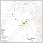
Iuvavum – the name is connected with the river Iuaro or Ivarus (Salzach) – lies at an old established river crossing over the Salzach, below the city core of Salzburg, with the city centre and elevated residential district on the left bank, and a smaller, somewhat more recent settlement area on the right bank. On the mountain slopes nearby lie four hilltop settlements of the Latène period (Hellbrunnerberg, Kapuzinerberg, Rainberg, and Festungsberg). In the surrounding countryside, in the suburbs of the present-day city of Salzburg, the existence of six lowland settlements has been established. All of these are probably to be connected to the Ambisontii tribe which belonged to the regnum Noricum.
The earliest Roman structures at this junction of two trades routes – the Salzach-Inn route and the connecting road from Chiemsee via Ovilavis (Wels) leading to the Danube – date back to the period directly after the occupation of Noricum in ca. 15 B.C. The attainment of municipal rights in the Claudian period is certain. By the time of the Flavian period, the city had already experienced a great building expansion. After a thorough destruction in the period of the Marcomanni wars, the city enjoyed a period of material prosperity in the Severan period, when houses rich with mosaics, stucco decoration, and wall paintings were constructed.
There is no evidence for a military camp in the city district or in its environs.
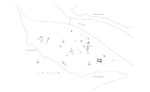
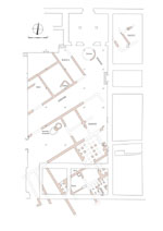
The maximum extent of the densely built-up area on the left bank of the Salzach encompasses an area of 800 x 400 m. A few individual stretches of street from the inner town have been excavated for short distances; these reveal that no regular orthogonal street system existed as a rule throughout the town. Instead, the streets oriented themselves according to the topographical conditions of the river and mountains; in some quarters, however, a regular grid of streets was formed. The known street widths are relatively narrow, in general between 4 – 5 m., rarely 7 m., certainly an indication of the shortage of building space. In a number of locations accompanying porticoes have been identified. At the excavations at the cathedral, the massive foundations of a quadrifrons, as yet unpublished, were encountered; according to an inscription found in the vicinity of the cathedral, this structure must have been erected for the Severan imperial house in ca. 205 A.D.
Due to lack of conclusive evidence, the site of the Forum has been proposed at a number of different locations. A central public building was located in the eastern region of the city (near Kaigasse 33), where various columns and other architectural elements, as well as isolated massive foundation walls, came to light.
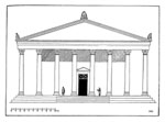
Only one temple building can be restored in ground plan; this probably underwent its final phase of construction during the Severan period. This building, the foundations of which were discovered in 1945 in Kaigasse, was a peripteral temple with exterior dimensions of 45.4 x 29.6 m. This cult building, unique of its kind to date in Noricum, was oriented east-west and, according to the available investigation results, possessed only one undivided interior room which was twice as deep as it was wide, measuring 32 x 16 m. In 1885, four statuettes of the healing god Asclepius were found in a pit in close proximity to the temple; one of them was a double-portrait depicting Asclepius and his partner Hygeia. In addition, a head of Cybele and a head of Sarapis were found. All of the statuary finds date to the 2nd or early 3rd century. Similarly discovered in the Kaigasse, an altar dedicated to Asclepius by Q. Sabinius Onesimus, a member of a leading Norican family, could significantly predate the temple. The obvious attribution of the temple to Asclepius based on the archaeological finds has been unanimously accepted, and finds only one other parallel in the northern provinces, at Trier.
An additional temple, located on the Nonnberg and dedicated to Mercury, is only attested via a building inscription.
 |
 |
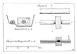
An aqueduct running from the Kapuzinerberg on the right bank of the Salzach led into the city; during reconstruction after the Second World War, two parallel tracks of wooden pipes from this aqueduct, ca. 10 m. in length, were dug up in the Linzer Gasse and dated to the 1st c. A.D. The pipes (bore hole ca. 3 – 3.5 cm. in diameter, pipe length 4 m.) were made out of black alder wood, the connecting blocks of oak wood.
Simple block houses conforming to native building traditions are known from the vicus of the Augustan period. For the early urban construction, half-timbered structures dominated, while after the late 1st c. A.D., private houses utilizing mortared quarrystone were the most common type. Complete ground plans of these complex houses of varying types, or even plans of complete insulae, have not been recorded anywhere due to the prevailing conditions in the inner city. In what follows, only a few examples will be presented.
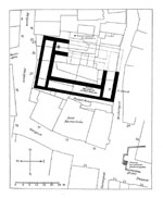
Beneath the western part of the cathedral and at the adjacent Domplatz (Cathedral Square), a peristyle house – the only one of its kind discovered to date in Iuvavum – has been identified; this had a total area of ca. 1,000 m². A courtyard paved with stone was enclosed on at least three sides by columnar porticoes (total width of courtyard and colonnade ca. 18 m.). Eight rooms and three corridors from the rest of the house have been partially excavated. These constituted the living quarters of the house: seven rooms received mosaics over the course of time, while three were heated. Beneath the floor ran a drainage system. Facing the street to the south were shops. Nothing is known regarding a commercial tract with kitchen and workrooms (in the north?). The peristyle courtyard was built on top of walls of a similar predecessor of the early 2nd century; the structure described here was constructed in the late 2nd century and was renovated and decorated into the 4th century.
At the so-called Kapitelhaus, excavations brought to light the remains of two courtyard houses on both sides of a side street. Here only the ground plans of the early and late 2nd century will be considered, as the earlier half-timbered constructions cannot be more closely understood. The floors of the interior rooms were of cement or terrazzo, while for the open-air units, beaten loam was used; in general the walls were whitewashed. In the early 2nd century, House A possessed a group of three rooms parallel to each other in the north; in front of these, facing the street, there was apparently a portico. To the south of the group of rooms lay a courtyard with an open porch at its north side, and a hearth. The courtyard was not accessible from the street adjacent to the east. At least three additional small rooms opened off the courtyard to the west, to the next side street. The southern extension of the house is not known.
The reconstruction after the catastrophe of the Marcomanni wars revealed a drastically changed picture. In the courtyard, instead of the porch there now existed a basin; the hearth continued to be used. The largest living room in the north-east was now fitted with heating, and in the enlarged corner room at the north-west a closed baking oven was built. The three rooms at the west were removed in favour of a hall open to the side street. Overall, the impression is of an increased commercial usage for the known areas of the building.
The neighbouring House B underwent a similar development. Three parallel rooms, staggered from north to south and one having a cistern, lay along the street and at the street intersection; at the south, a row of additional rooms with an economic function (kitchen with hearth) was located. During the rebuilding in the late 2nd century, here too the northern corner room was fitted with subfloor heating throughout, and in the adjoining room the cistern was abandoned.
 |
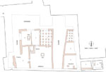 |
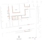
Three courtyard houses, with similar yet more complex multi-room arrangements and with a location at a street junction, have been identified in the court of the Neue Residenz. Here too the construction phases of the early and late 2nd century for Houses A and B were related to each other. At House A, a narrow corridor served as the entrance room behind a portico at the east; behind this vestibule were a perpendicular corridor and a workyard with a furnace. Further to the west, a narrow and a wider room adjoined these two. In the rebuilding phase following the Marcomanni wars, a cellar was dug out in place of the large room, and in the courtyard a cistern was laid out instead of the furnace, with an additional cistern instead of the portico in the space next to the street.
The excavated area of House B is substantially larger and shows four rows of rooms. The known constructed area covers roughly 25 to 30 m. On the street side, once again a large workyard existed, at first the site of a smithy, then of a pottery kiln. In Phase 2, the number of rooms was increased by decreasing their size. In the rows of rooms at the rear, at least three rooms and two corridors received hypocaust heating systems.
 |
 |
9 Neue Residenz, Houses A to C: ground plans of building phase 1 (early 2nd century)
10
The finds from Iuvavum are for the most part located in the Salzburger Museum Carolino-Augusteum; in addition, stone monuments and mosaics can be viewed in various locations in the inner city (for example in the Wallistrakt and in the Stift St. Peter). The Dommuseum displays Roman architectural remains and finds from a richly equipped private house.
Select Bibliography
Hl. Rupert von Salzburg, Ergänzungsband: Archäologische Entdeckungen in der Erzabtei St. Peter in Salzburg (1996).
M. Hell, Reste römischer Wasserleitungen in Salzburg, Mitt. Ges. Salzburger Landeskunde 98, 1958, 261–266.
M. Hell, Ein römischer Tempelbau in Juvavum-Salzburg, Mitt. Ges. Salzburger Landeskunde 100, 1960, 29–44.
N. Heger, Salzburg in römischer Zeit, Jahresschrift Salzburger Museum Carolino-Augusteum 19 (1973).
N. Heger, Die Skulpturen des Stadtgebietes von Iuvavum, CSIR Österreich III 1 (1975).
N. Heger, Frührömische Amphoren aus der Stadt Salzburg (Mozartplatz 4), Bayerische Vorgeschichtsblätter 51, 1986, 131–161.
W. Jobst, Römische Mosaiken in Salzburg (1982).
P. Karnitsch, Sigillata von Iuvavum (Salzburg). Die reliefverzierte Sigillata im Salzburger Museum Carolino-Augusteum, mit einem Beitrag von N. Heger, Jahresschrift Salzburger Museum Carolino-Augusteum 16 (1970–1971).
W.K. Kovacsovics, Iuvavum – Zum Beginn und zur Entwicklung der römischen Stadt im 1. Jahrhundert, in: Genese, Struktur und Entwicklung römischer Städte im 1. Jahrhundert n. Chr. in Nieder- und Obergermanien, hrsg. v. G. Precht, Xantener Berichte 9 (2001) 227–244.
W.K. Kovacsovics, Iuvavum, in: M. Šašel Kos – P. Scherrer (Hrsg.), The Autonomous Towns in Noricum and Pannonia – Die autonomen Städte in Noricum und Pannonien: Noricum, Situla 40 (2002) 165–201.
W.K. Kovacsovics, Iuvavum – Neue Beobachtungen zur Struktur der römischen Stadt, in: L. Borhy, P. Zsidi (Hrsg.), Die norisch-pannonischen Städte und das römische Heer im Lichte der neuesten archäologischen Forschungen. Aquincum Nostrum II 3 (2005) 145–158.
W.K. Kovacsovics – R. Kastler, Domgrabungsmuseum Salzburg (2004).
H. Lange, Römische Terrakotten aus Salzburg, Schriftenreihe Salzburger Museum Carolino-Augusteum 9 (1990).
E. Thüry, Der Quadrifrons von Juvavum, Mitt. Ges. Salzburger Landeskunde 107, 1967, 67–70.
Excavation reports regularly appear in: Salzburg Archiv; Fundberichte aus Österreich.
Iuvavum – Illustrations
1 Location of finds from the prehistoric period in the greater Salzburg area, and the position of the municipium Iuvavum
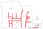
2 Plan of the known Roman buildings and streets, with the location of the Roman bridge over the Salzach
3 Peripteral temple dedicated to Asclepius: ground plan
4 Peripteral temple dedicated to Asclepius: reconstruction sketch
5 Wooden pipes from an aqueduct: sketch of the functional connections
6 Domplatz, Peristyle villa: ground plan
7 Kapitelhaus, Houses A and B: ground plan of building phase 1 (early 2nd century)
8 Kapitelhaus, Houses A and B: ground plan of building phase 2 (late 2nd century)
9 Neue Residenz, Houses A to C: ground plans of building phase 1 (early 2nd century)
10 Neue Residenz, Houses A to C: ground plans of building phase 2 (late 2nd century)