Siehe diesen Text auf ![]()
The name Lauriacum is Celtic (roughly, ‘near the people of the Laurios’), yet a pre-Roman settlement of any great extent in the vicinity cannot be identified.
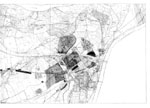
In Lauriacum, to the left of the mouth of the River Enns at the Danube, a not-insignificant vicus already existed in the second half of the 1st c., with constructions in the form of row houses along the Limes road, identical to today’s Stadelgasse. Further to the west, a second settlement core grew up at the earliest in ca. 175 A.D.; this is today generally referred to as the ‘civilian city.’
During the course of the Marcomanni wars, the legio II Italica was at first stationed at Albing on the right bank of the river Enns, however after ca. 190 then in Lauriacum, where it remained until late antiquity. Thereby, Lauriacum became the permanent seat of the legatus Augusti propraetore, the governor of the province of Noricum. To the north of the military camp, extensive canabae legionis grew up, while the slightly older settlement to the west of the camp also rapidly expanded, and fused together with the earlier vicus to the south of the camp.
Based on the finds of numerous fragments of bronze tablets with paragraphs alluding to municipal rights, many scholars have assumed that the settlement attained these rights during the reign of Emperor Caracalla (211-21). The fragments, however, originate from scrap metal – adapted for re-use – from late ancient contexts, and belong to at least five separate documents; for this reason they might represent copies or transcripts of civic rights of other Norican cities. Furthermore, since no inscription or other source mentions a statute or civic authority, and Lauriacum has never been attested as the place of origin, the existence of municipal rights must continue to be doubted.
 |
 |
Older scholarship assumed the existence of an auxiliary camp dating to the 1st/2nd century, which has to date not been archaeologically identified and today is held to be unlikely. The only camp must have been that of the legio II Italica pia fidelis, which must have been occupied still prior to 200. In addition to the legion, milites auxiliares Lauriacenses are mentioned on brick stamps and on a stone inscription. In late antiquity, the notitia dignitatum attest a classis Lauriacensis and lanciarii Lauriacenses.
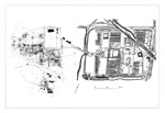
The lay-out of the residential quarter in the so-called civilian town was aligned according to the pre-existing conditions of the Limes road, which ran around the military camp to the south, and two roads oriented to the porta decumana of the camp. The street which constituted the extension of the decumanus of the camp, one which is today still described as the central street, could be interpreted as the decumanus maximus of the civilian town. At least one street to the south of this, and more in the north, run parallel. Not much is known regarding the cardines which usually were constructed here.
The extent of the constructed area of 400 x 600 m., known from excavations which took place from the 1950s to the 1970s, has been surpassed by far due to recent, unpublished rescue excavations.
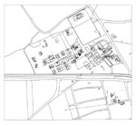
All of the known public buildings with an official function lie on the eastern perimeter of the so-called civilian town, at the border of the unbuilt strip of land next to the legionary camp.
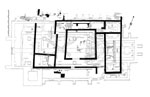
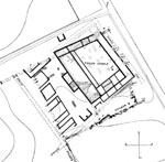
At the very north of the known built-up area, beneath the church of St. Laurentius which has existed from late antiquity until today, an imposing residential structure with an area of more than 1,200 m² and at least one large hall has been excavated. The building underwent up to as many as six phases of construction, beginning in the late 2nd century, before it was converted into a church in the 5th century. The opinion of the excavator, that it was a temple dedicated to the Capitoline Triad or to a local version of Mars, is now unanimously rejected. The structure was in all probability the praetorium of the commander of the legion and governor of the province of Noricum. The plans of the building phases which the excavator produced are in many aspects devoid of all probability, and are currently being completely reworked. The surrounding cemetery, still in use today, has hindered extensive modern investigations.
To the south of the cemetery of the church of St. Laurentius, a trapezoidal area between the two streets which ran to the camp gate was revealed; this is known as the forum venale (market place) and has average dimensions of 50 x 63 m. At the west, a basilica equipped with numerous heating channels has been reconstructed; along the long side opposite, a simple colonnade. At the north and south, a series of different rooms was cut into. Free-standing buildings in the north and south-west have only been partially excavated; they have been hypothetically identified as temples, although there are no conclusive grounds for this identification. A convincing interpretation of the row of large rooms, separated by passageways, to the west of the basilica is equally difficult.
Temples or sanctuaries have not yet been identified in Lauriacum. There is some evidence for water conduits. A city wall never existed, as the population relocated in late antiquity to the legionary camp which at that time was sparsely settled.
In general, the domestic structures can be described as free-standing buildings with a forecourt and an interior court; a uniform insula-system cannot be identified. At any rate, the majority of the private houses have only been partially excavated, and from the current state of publication, nothing can be said regarding their individual building phases, their chronology, and their ground plans with any degree of certainty.
The enclosing trenches of the legionary camp, to the north and east in the countryside, are in part recognisable. Beneath the basilica of St. Laurentius, the ruins of the probable praetorium, and the early Christian church which was erected over it, have been conserved. The Museum Lauriacum is located in the town square of Enns.
L. Eckhart, Die Skulpturen des Stadtgebietes von Lauriacum, CSIR Österreich III 2 (1976).
Florian 2004. Entflammt. Katalog zu den Ausstellungen Enns – Lorch – St. Florian (2004).
Forschungen in Lauriacum I–XI (1953–2006).
H. Graßl, Neue Beiträge zu den Stadtrechtsfragmenten aus Lauriacum, Römisches Österreich 26, 2003, 7–10.
M. Hainzmann, Ovilava – Lauriacum – Virunum. Zur Problematik der Statthalterresidenzen und Verwaltungszentren Norikums ab 170 n. Chr., Tyche 6, 1991, 61–85.
P. Scherrer, Grabbau – Wohnbau – Turmburg – Praetorium. Angebliche Sakralbauten und behauptete heidnisch-christliche Kultkontinuitäten in Noricum, Berichte und Materialien des Österr. Archäolog. Inst. 4 (1992) bes. 15–26 u. 45.
P. Scherrer, Lauriacum und Ovilavis in Noricum – Eine verwaltungsgeschichtliche Spurensuche, in: Römerzeit – Mittelalter. Archäologische und kulturwissenschaftliche Beiträge. Festschrift Herma Stiglitz (1996) 85–90.
H. Ubl, Lauriacum. Die zivilen Siedlungsräume, in: M. Šašel Kos – P. Scherrer (Hrsg.), The Autonomous Towns in Noricum and Pannonia – Die autonomen Städte in Noricum und Pannonien: Noricum, Situla 40 (2002) 257–276.
H. Vetters, Lauriacum, ANRW II 6 (1977) 355–379.
R. Zinnhobler (Hrsg.), Lorch in der Geschichte, Linzer philosophisch-theologische Reihe 15 (1981).
Excavation Reports and Studies appear : Fundberichte aus Österreich; Mitteilungen des Musealvereins Lauriacum.