Siehe diesen Text in Deutsch ![]()
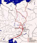
The conquest by Rome of the north-western Balkan region, at that time known
as Illyricum, was initiated under Octavian, the later emperor Augustus, in 35
B.C. After 16/15 B.C., two military units, under the leadership of Tiberius,
the step-son of Augustus, and of Drusus, carried out a pincer attack for the
acquisition of the provinces of Raetia and Vindelicia, Noricum, and the region
which after 20 A.D. was known as Pannonia. At the outset, Pannonia was part
of the province of Illyricum; most likely under Emperor Claudius (41-54), at
the latest however under his successor Nero (54-68), Illyricum was divided and
Pannonia became a separate province. Together with Noricum, however, it remained
part of the Illyrian region for customs and duties; for this reason the border
- which in other regions is ascertained by the location of toll stations – can
hardly be identified. From the mid-1st c. B.C. up until the reign of Claudius,
the area which would later become the north-west Pannonian region – i.e. from
the Wienerwald (Vienna Woods) southwards to the Buckligen Welt (Hilly Regions)
at the foothills of the eastern Alps, and to the east at least as far as the
Neusiedler See, indeed probably as far as Balaton - belonged to the region influenced
by the kingdom of Noricum or to the succeeding Roman province. In the year 6
A.D., Tiberius, in the course of preparations for a war of conquest of the Marcomanni
region, spent the winter in Bohemia, “in Carnuntum, a site in Noricum,”
as a Senator and officer, Velleius Paterculus, who was stationed beneath him,
wrote in his report of the campaign. The revolt by the Pannonian tribes, utterly
unexpected by the Romans, which broke out under their leader Bato not only hindered
these offensive plans but also threatened the entire existence of Rome. After
three years of bloody war, the revolt was suppressed and the Pannonian tribes
harshly punished, decimated, and partially relocated; young men who were fit
for military duty were ordered to the Roman auxiliary legions and sent to remote
provinces for military service. A city, Savaria, was only founded in Pannonia
in the mid-1st c. A.D, populated by military veterans; the native
inhabitants were relocated to the immediate environs of this town. At the end
of the 1st c. A.D., many native civitates still stood under
the direct supervision of a Roman centurio or of an equestrian officer.
Such an officer, a praefectus by the name of Lucius Volcacius Primus,
carried out his duties under the emperor Domitian (81-96) as supervising officer
of the Danube border areas (ripa Danuvii) and the tribes of the Azaler
(in the area around Arrabona/Gyõr and Brigetio/Komárom) and the Boii (with their
original centre near Devin and Bratislava).
In the early 2nd c., principes (princes) descended from
the local nobility served as contacts between the Romans and these tribes; after
Hadrian, the civic functionaries in the new municipalities seem to have carried
out the supervision over the local population.
The special military significance and the economic strength of the region eastwards
of the Wiener Becken (iron ore and fertile black soil), was reinforced by its
location on the ancient trade route between the Adriatic and the Baltic Sea,
the so-called Amber Route. At the final division of the provinces of Noricum
and Pannonia, which until the reign of Claudius had been under the control of
a higher military commando, these circumstances eventually resulted in the fact
that the entire region to the east of the Eastern Alps, from Vindobona/Vienna
as far as Poetovio/Ptuj, was separated from the calmer and less dangerous, and
thus not heavily militarily occupied province of Noricum, still administered
by a civil procurator, and converted into the province of Pannonia, under the
control of four legions.
 |
|
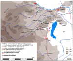
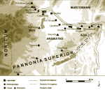
Roman, German and Celtic settlements in the 1st c.
A.D. in north-west Pannonia |
|
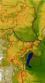
Overview of Roman settlement in the eastern part of
the province of Pannonia superior, and settlement sites with Roman finds
in Barbaricum in norther Lower Austria |
The emperors from Vespasian (69-79) until Trajan (98-117) consolidated the Danubian lines militarily in Pannonia, as in neighbouring Noricum. Possibly in the year 106 (although perhaps already in 102), Trajan divided Pannonia into the province of Pannonia superior, located upstream on the Danube and provided with three legions, and Pannonia inferior further to the south-east, with only one legion stationed at Aquincum/Budapest. The border between the two Pannonian provinces ran roughly from Esztergom to the Balaton and then further to the south, until it met the Province of Dalmatia, the former southern part of Illyricum, to the south of the Save valley. Under Caracalla, in the year 214 the legionary location of Brigetio, with its surrounding region, was assigned from Pannonia superior to the province of Pannonia inferior, whereby both provinces were now provided with two legions each.
From the conquest of Pannonia up until the early 2nd c. A.D., Poetovio/Ptuj
on the Amber Road served as the legionary site, in order on the one hand to
secure the important communication routes, on the other to cordon off Italy
in the case of a new revolt by the southern Pannonian tribes or in the case
of a new enemy attack. An auxiliary troop camp was located slightly to the north
at Salla. In the 2nd c., cities were founded at the sites of both camps, and
the legionary camp was relocated to Brigetio/Komárom.
In upper Pannonia, after the reign of Trajan (98-117) until the beginning of
late antiquity military camps were only located along the Danube. The sites
of legionary camps were Vindobona/Vienna (built by the legio XIII gemina
under Domitian, after the Dacian Wars of 104/107 continuously the home base
of the legio X gemina), Carnuntum/Bad Deutsch-Altenburg (occupied after
the mid-1st c. primarily by the legio XV Apollinaris, after
Trajan by the legio XIV gemina Martia victrix), and Brigetio/Komárom
(after Trajan, the base of the legio I adiutrix).
At Vindobona, in addition to the area west of the legionary camp, which formed
the nucleus of the later city of Vienna, a cavalry camp (ala I Flavia milliaria)
seems to have existed near or to the north-east of the Votivkirche. An additional
cavalry camp (ala I Thracum) at Carnuntum, on the eastern boundary
of the site of Petronell, has been extensively excavated in the past 30 years.
At Brigetio, an auxiliary troop unit, the cohors I Britannica milliaria,
existed since the mid-1st c. A.D., before the legion was stationed there; furthermore,
a bridge-head camp was located on the opposite bank of the Danube at Iža (Slovakia).
Additional auxiliary troops in the west of the province were located at Arrianis?/Klosterneuburg
(at first the cohors II Batavorum, then the cohors I Aelia sagittariorum),
Ala Nova/Schwechat (ala I Thracum victrix?), Aequinoctium/Fischamend
(infantry, company unknown). To the east of Carnuntum came the fort of the ala
I Canninefatium in Gerulata/Rušovce (Slovakia) and then – in what is today
Hungary – the camps of Ad Flexum/Mosonmagyaróvár and Quadrata/Lébénymiklós,
occupied by unidentified companies and/or legionary vexillation. At the confluence
of the rivers Rába (Raab) and Rábca (Rabnitz) into the Danube, the camp of Arrabona/Gyõr
was already laid out during the reign of Claudius at this important road intersection;
the ala I Ulpia contariorum milliaria garrison moved into this in the
early 2nd century A.D. The next fort along the way to Brigetio, Ad
Statuas/Ács-Vaspuszta, was first in the final quarter of the 2nd
century in the wake of the Marcomanni wars, as a wood-and-earth construction,
and completed during the reign of Caracalla in stone construction. The neighbouring
fort Ad Mures/Ács-Bumbumkút seems to date back to the Trajanic period, and served
as quarters for a vexillation of the legio I adiutrix. After Brigetio
came the forts of Odiavum/Almásfüzitõ and Crumerum/Nyergesújfalu, today almost
completely destroyed. The camp of the cohors I Ulpia Pannoniorum milliaria,
a 1000-man strong infantry regiment, was located at Solva/Esztergom on the border
with Pannonia inferior.
 |
 |
 |
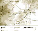
The settlements of northern Pannonia in the Claudian
period (mid-1st c. A.D.) |
The settlements of northern Pannonia in the Flavian
period (final third of the 1st c. A.D.) |
The settlements of northern Pannonia in the first half of the 2nd c. A.D. |
The so-called Amber Road, an important trade route from the Adriatic port of Aquileia to the north, ran through western Pannonia, crossing the Danube near Carnuntum. This route was controlled by the legions which were permanently stationed after the mid-1st c. A.D. at Carnuntum (Bad Deutsch-Altenburg) and Vindobona (Vienna); in addition, the governor’s seat of the province of Pannonia was relocated to Carnuntum. The colonia Claudia Savaria (Szombathely) was founded on the Amber Road during the reign of Claudius (41-54 A.D.), as seat of the Pannonian provincial parliament and, thereby, as the civil “capital”. Similarly on the Amber Road, further to the south, the former legionary base of Poetovio was elevated under Emperor Trajan to the status of a Colonia, and also served as the seat of the customs authorities (portorium Illyricum). To the south of the Neusiedler See, a trading base for immigrant traders from Italy was founded – already during the reign of Augustus or Tiberius – at the oppidum Iulium Scarbantia (Sopron), which was elevated to the rank of a municipium under the Flavian emperors.
 |
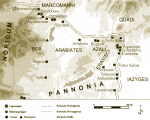
The course of the Amber Road from the Adriatic to the Baltic Sea |
From the Amber Road, communicating routes led to neighbouring towns in the
west: one ran from Savaria over the Raab valley and the settlement in Gleisdorf
into the Mur valley near Kalsdorf, to link up with the road to Flavia Solva;
another led from Scarbantia to Vindobona. These northern routes served above
all as connections to the iron-rich regions in central Burgenland (Eisenstadt)
and in the Buckligen Welt surrounding the late Latène settlement near Schwarzenbach.
The two legionary stations at Carnuntum (at the latest under Claudius) and Vindobona
(probably since Domitian, that is between 81 and 96 A.D.), received their civic
rights at a relatively late date, as did most of the sites on the Danube border;
this circumstance is consistent with the rise in importance of the Danube in
the 2nd c. as a trading route. The civilian settlement ca. 2 km.
to the west of the legionary camp of Carnuntum, in the region of what is today
Petronell, became a municipium probably in 118, on the occasion of
a personal visit by the emperor himself to the province. Septimius Severus,
who was acclaimed emperor in Carnuntum in April 193 while serving as governor
of Upper Pannonia, bestowed the title of colonia on the city in gratitude.
The municipal rights of Vindobona are attested on only one single inscription,
found in the city centre of Vienna during the Renaissance and thereafter lost.
While earlier scholarship favoured the bestowal of the rank of a municipality
at the earliest under Caracalla (211-217), recently convincing arguments have
been proposed that this occurred already under Hadrian. In each case, at both
sites the elevation in rank had to do with their flourishing as legionary stations,
and little to do with their predecessors of the Latène period.
In the hinterlands of Vindobona and Carnuntum, scarcely any large-scale settlements
are known; the land served primarily as an agricultural and forestry region
for the support of the legions and city residents. The warm springs of today’s
curative spa site of Baden, south of Vienna, were already used during the Roman
period under the name Aquae. Scientific excavations, however, have never taken
place here.
P. Scherrer – H. Sedlmayer
H. Friesinger – F. Krinzinger (Hrsg.), Der römische Limes in Österreich. Führer zu den archäologischen Denkmälern (1997)
V. Gassner – S. Jilek – S. Ladstätter, Am Rande des Reiches. Die Römer in Österreich, Österreichische Geschichte 15 v. Chr. – 378 n. Chr. (2002)
F. Humer (Hrsg.), Legionsadler und Druidenstab. Vom Legionslager zur Donaumetropole. Sonderausstellung aus Anlass des Jubiläums „2000 Jahre Carnuntum“, Catalogue and Text volume (2006)
M. Kandler – H. Vetters (Eds.), Der römische Limes in Österreich. Ein Führer (1986)
O.H. Urban, Der lange Weg zur Geschichte. Die Urgeschichte Österreichs, Österreichische Geschichte bis 15 v. Chr. (2000).
Zs. Visy, Der pannonische Limes in Ungarn (1988)