Siehe diesen Text auf ![]()
At the western border of the Vienna Basin, on the Leopoldsberg, a Boian ‘oppidum’ was situated up until the beginning of the Augustan period; additional settlement remains and pottery kilns have been found above all in the 3rd District of Vienna, in the area where the Roman civilian settlement later developed. The name of these remains, Vindobona, can perhaps be traced back to a Celtic ‘Vindo’ (estate of Vindo). After the defeat of the Boii by the Dacians, the region around Vindobona belonged to the regnum Noricum from the mid-1st c. B.C. until the early Imperial period, at the latest after Claudius to Illyricum and Pannonia, and after Trajan to the province of Pannonia Superior (Upper Pannonia).
Vienna environments in Roman times
The earliest traces of a Roman military presence could date to the Augustan-Tiberian period, while in the years after 80 A.D. a legionary fort and an equestrian camp were set up in the 1st District. Only a very few remains of houses at the Michaelerplatz and at the Freyung have been excavated of the canabae legionis which developed after the late 1st c. A.D. to the south-west, south and east of the legionary camp, and which must have covered a built area of ca. 94 ha.; in addition, pottery kilns have been found at the Neuer Markt. The cemeteries are better known, although equally only partially excavated.
The civilian settlement of Vindobona in the 3rd District (Wien-Landstraße) along the Rennweg, which is identical to the connecting thoroughfare between the legionary camps of Vindobona and Carnuntum, was gradually developed from the mid- to late 1st c. as a village along the road. Only one lone inscription, discovered in the Renaissance and unfortunately since lost, identifies the status of the settlement as a municipium. Formerly, it was believed that a formal city foundation first took place under Emperor Caracalla (211-217); today, however, a number of indications, including a list of the cities of the province of Pannonia Superior originating from Rome itself, suggest that an elevation in rank already occurred under Hadrian.
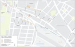
General plan river system
The earliest military presence in Vindobona is attested by a tomb stone of an active legionary of the legio XV Apollinaris probably erected before the reign of Claudius. The military camp in the 1st District, however, was most likely first set up in the Domitianic period on top of earlier settlement traces. The legio XIII Gemina was stationed here until 101 A.D., after that, but probably only until 114, the legio XIV Gemina Martia Victrix. Building inscriptions relating to the camp are preserved for both legions. From the late Trajanic period, up until the end of the Roman period in Pannonia in the 5th century, Vindobona served as the base of the legio X Gemina.
A camp for auxiliary troops might have been set up here shortly before the legionary camp. It is, however, certain that in the Domitianic and early Trajanic period an ala I Flavia Augusta Britannica milliaria civium Romanorum was stationed in Vindobona, and in addition an ala I Batavorum up until 118/119. According to the most recent research, these cavalry camps might have been located most probably to the west of the legionary camp, in the area of the current Schottenring – Votivkirche.
 |
 |
Sites from the late
1st Century AD
|
Extension of the municipium
Vindobonense
|
The long-distance route (so-called Limes Road), identical with the line of the Rennweg – Aspangstraße, a street between house constructions along the Rennweg, certainly served as the main axis (decumanus maximus) of the municipium. Pointed trenches found at three separate locations marked the borders of the settlement. Two ditches ran approximately parallel to the Rennweg, and reveal an extent of the settlement of ca. 300 m. in a north-south direction. The south-easternmost trench corner lies near the Aspang train station. Remains of houses lying furthest away from here to the west (at Rennweg 12-14) reveal a minimum length of the city of ca. 1.4 km., whereby the planned settlement region must have covered a total area of over 40 ha. From the total eastern half, practically only graves of the vicus of the 1st c. A.D. have come to light until now, although it is assumed that the Forum and a bathing complex were located precisely here. The previously mentioned houses, occupied since the Flavian period, were located on both sides of a road leading to the Rennweg at right angles, a circumstance which at least suggests the existence of a rectangular grid plan for the streets. In sum, it appears that in the western section of the municipium an older vicus existed, whereas the eastern half was only first settled after the elevation in status of the town; in this new settlement area, the public buildings could be erected without running into legal problems regarding ownership.
The location of the Forum is not known. Based on the find-spot of fragments of a bronze Jupiter statue and a marble statue of an Emperor during the construction of the Wiener Neustadt canal in the 19th c., the Forum lay in the eastern section of the town near what is today the Ziakplatz.
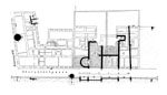
A small bathing complex (width ca. 26 m., excavated length 23 m.), situated at the Oberzellergasse to the north of the house at Rennweg 87 and dating to the 2nd/3rd c., was already studied at the beginning of the 20th century.
In a number of places in the 12th and 23rd districts, that is in the south-west of Vienna (e.g. Wundtgasse, Rosenhügel), a walled aqueduct was cut through; it is unclear, however, what its destination would have been (legionary camp or municipium).
Underneath the modern city, it has only seldom been possible to excavate larger areas adjacent to each other in which complete ground plans of houses might have been able to be studied. Sections of houses, frequently in combination with workshops - in particular pottery kilns - have been discovered since the 18th c. in numerous locations along the Rennweg and its side streets. Most of the houses can be identified as wooden framework structures, with or without stone wall socles. As far as can be determined, the houses were in part laterally disposed row houses, and in part – above all where stone (foundation) walls have been found – houses of block-form ground plan with two parallel rows of rooms.
Underneath the Hohen Markt, small sections of two tribune houses, architectural fragments, inscriptions, and stamped tiles and bricks belonging to the Legionary camp can be seen, while at the house located at Am Hof 9 part of a drainage canal beneath the via sagularis is preserved. Part of the south-west tower of the camp is built into the cellar of the house at Naglergasse 26. There are no finds from the canabae legionis or the municipium visible in their original location. At the Freyung are vitrines with Roman finds, primarily ceramics, found during the excavations there.
Most of the archaeological finds from Vienna are kept in the Wien-Museum (at the Karlsplatz), while a few of the more impressive finds, above all stone monuments, are in the Kunsthistorisches Museum (on the Burgring).
P. Donat – E. Pichler, Überlegungen zur Entstehung der Zivilsiedlung von Vindobona, in: Akten des 9. Österreichischen Archäologentages am Institut für Klassische Archäologie der Paris-Lodron-Universität Salzburg vom 6. bis 8. Dezember 2001, hrsg. v. B. Asamer – W. Wohlmayr (Wien 2003) 27f., Taf. 5 Abb. 21.
P. Donat – E. Pichler – H. Sedlmayer, Aspekte spätkeltischer und frührömischer Siedlungsentwicklung in Wien-Landstraße, Fundort Wien 5, 2002, 76–100.
P. Donat – S. Sakl-Oberthaler – H. Sedlmayer et al., Die Wohnbereiche der canabae legionis von Vindobona. Befunde und Funde der Grabungen Wien 1, Michaelerplatz (1990/1991), Fundort Wien 8, 2005, 3–90.
R. Gietl – M. Kronberger – M. Mosser, Rekonstruktion des antiken Geländes in der Wiener Innenstadt, Fundort Wien 7, 2004, 32–53 (= Forum Archaeologiae 28/IX/2003; http://farch.net).
M. Großmann, Untersuchungen zum Iuppiter- und Kaiserkult im municipium Vindobonense – ein Diskussionsbeitrag, Fundort Wien 7, 2004, 198–210.
O. Harl, Vindobona. Das römische Wien, Wiener Geschichtsbücher 21/22 (1979).
F. Krinzinger (Hrsg.), Vindobona – Beiträge zu ausgewählten Keramikgattungen in ihrem topographischen Kontext, Archäologische Forschungen 12 (2005).
M. Kronberger, Siedlungschronologische Forschungen zu den canabae legionis von Vindobona. Die Gräberfelder, Monografien der Stadtarchäologie Wien 1 (2005).
M. Kronberger – M. Mosser, Vindobona – legionary fortress, canabae legionis and necropolis, in: Ph. Freeman – J. Bennett et al. (Hrsg.) Proceedings XVIIIth Internat. Congress of Roman Frontier Studies (Sept. 2000), British Archaeological Reports, Internat. Ser. 1084, II (2002) 573–584.
I. Mader, Vindobona. Die zivile Siedlung, in: M. Šašel Kos – P. Scherrer (Hrsg.), The Autonomous Towns in Noricum and Pannonia – Die autonomen Städte in Noricum und Pannonien: Pannonia II, Situla 42 (2004) 67–74.
M. Mosser, Zivile und militärische Aspekte in der Nutzung des Legionslagerareals von Vindobona, in: Die norisch-pannonischen Städte und das römische Heer im Lichte der neuesten archäologischen Forschungen. II: Internationale Konferenz über norisch-pannonische Städte, Budapest-Aquincum 11.–14. September 2002, Aquincum Nostrum II 3 (2005) 159– 178.
M. Mosser, Zur Präsentation des Legionslagers Vindobona im Rahmen der Science Week 2002; in: Forum Archaeologiae 24/IX/2002; http://farch.net.
A. Neumann, Die Skulpturen des Stadtgebietes von Vindobona, CSIR Österreich I 1 (1967).
I. Piso, Municipium Vindobonense, Tyche 6, 1991, 171–177.
I. Weber-Hiden, Die reliefverzierte Terrasigillata aus Vindobona, Wiener Archäologische Studien 1 (1996).
Excavation reports and studies appear annually since 1998 in: Fundort Wien, Berichte zur Archäologie
Vindobona – Illustrations
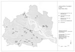
1 Latène Period finds in the area around Vienna: in the late Latène Period an oppidum was located on the Leopoldsberg (no. 30, at the extreme west), and flat land settlements in the 3rd District, roughly in the region of the later municipium (nos. 3-11) as well as north of the Danube in the area of Aspern (nos. 34-36).
2 The Vienna region in the Roman period: Legionary camp, Canabae, civilian town, burial fields, road stations, and sites of economic importance in the surrounding area
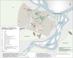
3 Overall plan: the system of rivers and streams in the 1st district of Vienna, and the site of the legionary camp, auxiliary fort, and canabae legionis
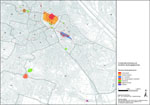
4 Locations of finds from the late 1st c. A.D. in the western area of the later municipium Vindobonense
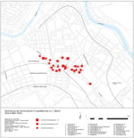
5 Extension of the municipium Vindobonense in the 3rd Vienna district: Roman tombs (C) and building remains
6 Bathing complex in the area of Rennweg/Oberzellergasse: ground plan
7 Houses belonging to the 1st – 2nd c. A.D. at Rennweg 12-14.