Siehe diesen Text auf ![]()
The only municipium in Noricum to have been founded during the Flavian period, specifically by Vespasian (69-79), Flavia Solva, lies on the west bank of the river Mur near the mouth of the Sulm brook, which is considered to have provided the site with its name. Already by the mid- to late-Augustan period, a vicus with wooden houses existed at the river crossing. In other places, wooden structures of the mid-1st century A.D. (Claudian-Neronian period) have been identified; the orientation of these structures deviated significantly from the Flavian land survey of the town. A continuous settlement up to the time of the elevation in rank of the city has not yet been identified. The military were apparently never stationed in the city and its environs.

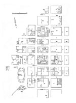
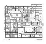
According to current knowledge, the city possessed a densely built-up area of almost 600 x 400 m., and was originally roughly square in the form of its plan. The areas of construction at the east of the town which no longer exist today, where the Forum and other public buildings were located, must have been destroyed in the post-antique period by the river Mur and partially washed away. The city blocks, which were regularly laid out and enclosed by walls, were separated by streets between 12 and 20 m. in width. The two central rows of insulae, situated on both sides of the long-distance route coming from the north and identified as the cardo maximus within the city, had regular dimensions of ca. 71 m. in length (east-west) and ca. 59 m. in width. To the west there followed a city block row 45 m. in width, and from here to the city’s perimeter, the construction scheme, consisting of two additional insula rows, was relatively irregular. Seen from a west-east direction, the two central rows, between which the decumanus maximus must have run, were only a maximum of 41 m. in width, in contrast to the above-described block widths of ca. 60 m. In spite of what was apparently only a temporary settlement of parts of the town area in the late Augustan period, the city plan represents the result of a uniform planning, one which did not make allowances for pre-existing structures of the pre-urban period.
Approximately 70% of the city, in large connected areas, has been investigated via excavation and surface survey; unfortunately, however, most of the excavations were carried out before the Second World War and were not only insufficiently published, but the chronologies and building sequences which were arrived at are now also considered unreliable.
 |
 |
According to the current state of knowledge, the city never had a city wall, nor an aqueduct or drainage system; the water supply was provided for with springs and cisterns, and the drainage ran through open trenches along the roads. The cambered streets, between 16 and 22 m. in width, had a surface of consolidated gravel, trenches, and sidewalks which were in part provided with porticoes.
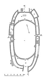
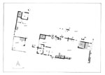
Based on parallels with Virunum and other cities, the Forum would have been located at the eastern end of the central narrow insula row. It was probably destroyed by the river Mur. Solva was provided with an Amphitheatre (XV), ca. 105 m. long and 50 m. wide, in the south-west corner of the town; this was already investigated before the First World War. The socle walls of mortared quarry stone probably supported wooden grandstands or terraces. The Arena measured 80 x 35 m. At the northern apex of the site lay a shrine of Nemesis, attested by an inscription.
To the south of the Amphitheatre, an enclosed building, irregularly laid out in comparison to the city plan, has been excavated; this had a smithy and a small bath, and probably served as the housing and training camp for the gladiators.
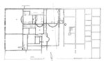
A structure built in the 3rd/4th century in Insula XXII in the town centre, with numerous rooms fitted with hypocaust heating, apses, and mosaics, is considered to be the main bathing establishment. Laid out from east to west, and separated by corridors, the frigidarium, caldarium and tepidarium follow in sequence after the heated apodyterium. An additional heated corridor ran to the south to another room with apse and subfloor heating; this is assumed to be a smaller bathing tract intended for women. At the western edge of the complex, two large courtyards measuring 13 m. wide and 12 – 18 m. long were located, customary spaces for relaxation after the bath.
 |
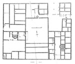 |
The eastern part of the bathing Insula XXII, and two parcels of the neighbouring Insula XXX (south-central and south-west parcels) were taken up by building complexes which can be classified most probably as trade- and market-buildings and/or hostels, based on the at least partial evidence of workshops and the central location in the city. It is questionable whether they also served as residences, as was formerly assumed. Three parallel rows of rooms each opened on to the street and to a wide, laterally disposed interior courtyard. In Insula XXII, in place of the third row of rooms, lay an additional courtyard with a single central room, suggesting a simple Macellum or similar structure. In the south-east parcel of Insula XXX, two of the three rows of rooms each possessed a single heated room, one of which was fitted with an apse. This one might have served as the local office of an aedile. In the north-west tract, the building construction was very loose, with open courts, accompanying halls, and only a very few individual rooms, similar to the situation in the south-central tract; furthermore, the middle of the insula seems to have remained completely undeveloped, leading one to think of a public park or an area for sporting activities. This interpretation is additionally supported by the existence of a bath with larger than usual courtyard and a row of relatively large rooms at the south, located in the south-west tract of the insula.
Recently, on the basis of georadar survey, the existence of a Mithraeum in the north-east quarter of the city was postulated; the survey picture, however, makes this unlikely, nor are any other temples known inside the city.
An important sanctuary lay outside the urban area, on the high ground of the Frauenberg located within sight of the town. The mountain preserves intensive traces of a Bronze Age and Iron Age settlement; on one of its projecting spurs is a late Latène period sanctuary, only partially excavated, in the form of a circular ditch. Its period of use ended at the latest under Emperor Claudius, probably when the region became an official Roman province and when Celtic cult practices, connected with human sacrifice, were proscribed. As the successor to this site, a temple (exterior dimensions 23.5 x 13.5 m.), dedicated to Isis on the basis of fragments of the building inscription, was erected on the highest point of the mountain, probably in the late Flavian period. The cella, which was roughly the same size as the pronaos, possessed a wide apse, while an altar for burnt offerings has been identified in the entrance area. The exterior appearance of the temple probably took the form of an open row of columns in the area of the pronaos, with half-columns engaged to the cella wall.
7 Sanctuary on the Frauenberg: Temple to Isis, and neighbouring sacred area (possible gallo-roman temple): ground plan
Image missing
Neighbouring this temple to the south-west lay the walls of a slightly distorted square area with exterior dimensions of ca. 7.4 x 8.9, erected in the Claudian-Neronian period; the interpretation of the excavation results is problematic. According to the opinion of the excavators, surrounding this, a second square enclosure with exterior dimensions of ca. 24.3 x 22.7 was laid out in the Flavian period, whereby an originally free-standing single-roomed cult building was converted into a temple of gallo-roman type. After the late 1st century A.D., however, the cult activities were relocated to the neighbouring Isis temple. In late antiquity, the temple with surrounding colonnade was apparently converted into a heated residence.
The large insulae in the town centre were divided into at least six parcels of land each with a good 600 m², whereby large private houses or official buildings also could take up two or more parcels of land, as insulae V, IX, XXII and XXX clearly show. In the 1st century half-timbered structures with stone socle walls predominated, a picture which also held true for the outer city regions later on. After the 2nd century, however, most of the houses in the city centre were constructed of pure stone masonry. For the private residences, all types are represented, from simple multi-room structures up to the peristyle house type.
Two large peristyle houses of almost the same size (ca. 46 x 30 m.), each covering two parcels of land, were located in Insula V. The open courtyard (10 x 18.5 m.) of the south-eastern house was frequently identified as the Forum of Solva in earlier literature. The complex building sequence of the houses is today difficult to comprehend; after rebuilding in the (early) 3rd century, each appears to have had a private bathing establishment with apsidal, heated main room, as did equally the smaller house in the north-east parcel of land. A similar picture is offered by the so-called ‘House of the Attii,’ a knightly family, in the neighbouring Insula IX.
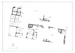
A completely different picture is provided by Insula XLI, located at the city’s perimeter and investigated around 1990. Here, building phase 1 (Flavian period up to the 2nd century) is characterised by small individual rooms or small groups of rooms situated in open courts and working areas. In building phase 2, after the attack by the Marcomanni, houses were erected which were apparently regularly laid out, were roughly square in form, and generally contained four to a maximum of six rooms; these houses covered an area of ca. 120 to 200 m² and occasionally had additional neighbouring buildings.
 |
 |
 |
A few stretches of walls from the residential buildings of Solva have been conserved, and in 2004 a small museum building was set up directly in the area of the excavations. An archaeological hiking trail has been created on the Frauenberg, leading to the temple structures and the temple museum, amongst other destinations. The majority of the archaeological finds are located at the Landesmuseum Joanneum, Schloß Eggenberg in Graz.
S. Groh, Die Insula XLI von Flavia Solva. Ergebnisse der Grabungen 1959 und 1989 bis 1992, Sonderschriften Österr. Archäolog. Inst. 28 (1996).
S. Groh – W. Neubauer – S.S. Seren – A. Eder-Hinterleitner – K. Löcker, Geophysikalische Messungen im nordöstlichen Stadtteil von Flavia Solva: Interpretation und archäologische Auswertung, Jahreshefte Österr. Archäolog. Inst. 71, 2002, 79–132.
S. Groh – H. Sedlmayer, Der norisch-römische Kultplatz am Frauenberg (Österreich), Protohistoire Européenne 9 (2005).
M. Hainzmann – E. Pochmarski, Die römerzeitlichen Inschrfiten und Reliefs von Schloss Seggau bei Leibnitz, Die römerzeitlichen Steindenkmäler der Steiermark I (1994).
E. Hudeczek, Flavia Solva, ANRW II 6 (1977) 414–471.
E. Hudeczek, Flavia Solva. Entwicklung und Topographie, in: M. Šašel Kos – P. Scherrer (Hrsg.), The Autonomous Towns in Noricum and Pannonia – Die autonomen Städte in Noricum und Pannonien: Noricum, Situla 40 (2002) 203–212.
E. Hudeczek, Die Römersteinsammlung des Landesmuseums Ioanneum. Ein Führer durch das Lapidarium (2004).
E. Krenn –U. Schachinger (Hrsg.), Neue Forschungen aus Flavia Solva, Archäolog. Ges. Steiermark Beiheft 3 (2003).
W. Kropf – H. Nowak, Fibeln von Flavia Solva aus Privatbesitz, Römisches Österreich 21/22, 1998–1999 (2000).
B. Schrettle, Der Tempelbezirk auf dem Frauenberg bei Leibnitz. Untersuchungen zu Architektur und Bauornamentik, Nachrichtenblatt Archäolog. Ges. Steiermark (2003).
G. Tiefengraber – Ch. Grill, Ein spätlatènezeitliches Heiligtum auf dem Frauenberg bei Leibnitz in der Steiermark(?) Archäolog. Korrespondezblatt 27, 1997, 601–616.
I. Weber-Hiden, Die Reliefsigillata von Flavia Solva, ein Überblick, Römisches Österreich 15/16, 1987–1988, 201–237.
Excavation Reports and Studies routinely appear in: Fundberichte aus Österreich.
Solva – Illustrations
1 Schematic overall plan of the city with numbered Insulae, necropoleis, and long-distance routes
2 Plan of the built-up area of Solva
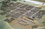
3 Model of the city lay-out
4 Amphitheatre: ground plan
5 Insula XXII: Baths and Market Building, ground plan
6 Insula XXX: Small Baths with park and area for sport (?) as well as Market Building, ground plan
7 Sanctuary on the Frauenberg: Temple to Isis, and neighbouring sacred area (possible gallo-roman temple): ground plan
8 Insula V with two Peristyle Houses oriented east-west (oldest period: black walls)
9 Insula XLI at the western perimeter of the city, construction in Period 1A (Flavian to mid-2nd century)
10 Insula XLI at the western perimeter of the city, construction in Period 2 (final third of the 2nd century)