See this text in German ![]()
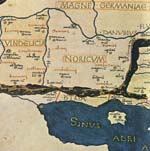
The geographical expansion of the free regnum Noricum prior to the Roman occupation in the year 15 B.C. can only be roughly estimated (Figs. 1-3). The nucleus of the region was located in the Drau Valley, and the entire south-eastern Eastern Alpine region, including Carinthia, Eastern Tyrol, parts of South Tyrol (Pustertal and Eisacktal), with at least southern Salzburg (Salzach- and Saalachtal) and areas of Styria and north-west Slovenia (the area around Celeia – Celje) also belonged to it.
The border of Noricum with Italy to the south must have been almost identical with the current border between Austria and Italy and Austria and Slovenia, with the exception of the Puster- and Eisacktal and the region around Celje. This leaves open the question whether the border ran across the mountain ridges of the Karawanken and Carinthian alps, as it does today, or around the southern feet of the mountains. The site of Iulium Carnicum/Zuglio, which after the Augustan reorganisation of Italy belonged to its regio X, and which at the latest under Claudius became a municipium, was described by the geographer Ptolemaios, based on his older (pre-Augustan) sources, as a site inter Noricum et Italiam.
After the destruction of the Boii in the mid-1st c. B.C., the Noricans also controlled the northern foothills of the Eastern Alps to the west of the River Inns as far as the Danube, while for a time their sphere of influence also extended to the east up to Balaton (Plattensee, lacus Pelso). According to the report of the general Velleius Paterculus concerning the march of the later Emperor Tiberius against the Marcomanni king Marbod, in the year 6 A.D. Carnuntum was still “a site in Noricum.”
At the latest during the reign of Emperor Claudius (41-54 A.D.), the regions to the east of the Vienna Woods and the catchment area of the river Raab were allotted to Illyricum and to the province of Pannonia which was founded shortly thereafter. On the Danube, the fort settlement of Klosterneuburg / Arrianis? directly west of Vienna certainly belonged to Pannonia, while the easternmost camp of Noricum was Zeiselmauer / Cannabiaca? To the south, the Imperial-period border between the provinces of Noricum and Pannonia (superior) cannot be identified with certainty. The small rivers south of Vienna which drained to the east, and the “Bucklige Welt” (hilly regions) most probably belonged to Pannonia, while in Styria, the entire Mur valley probably belonged to Noricum. The catchment area of the upper Raab up to the confluence of the Lafnitz is traditionally viewed as belonging to Noricum, but could already have belonged to Pannonia, as did the lower reaches of the river. The region around Maribor in Slovenia, with the marble quarries at Pohorje, ought at least economically to have been oriented towards Poetovio in Pannonia, but perhaps formally lay in Noricum.
In the west, the province of Raetia and Vindelicia bordered on Noricum;
in the north the border ran roughly along the course of the river Inns, after
Kufstein it probably ran roughly to the south over the Ziller- and Eisacktal,
these regions frequently changing hands in the Imperial period between belonging
to Noricum, and Raetia. Modern research disputes whether a particular strip
on the western bank of the Inns, from Passau to the Kuftsteiner Pforte, belonged
to Noricum, as certain indicators in the spectrum of finds suggest.
Based on the evidence provided by Claudius Ptolemaios (Geographike hyphegesis) and by epigraphic sources from the Magdalensburg and Paternion in the Drau valley in Carinthia, as well as from Iulium Carnicum / Zuglio (Friaul), it is possible to localize a series of population groups in the west and south of Noricum. The question as to which tribal groups the settlers belonged to remains open exclusively for the northern region, that is, the Alpine foothills along the Danube; here, probably, the population consisted of Boii or, up until the mid-1st c. B.C., population groups living under Boian sovereignty. In the time of Julius Caesar, the Norican King Voccio is named in connection with political contacts beyond the region; Caesar reports that the sister of Voccio was a concubine of the army commander of the Suebi, a certain Ariovist. It is reported for the year 49 B.C. that a Norican King (ab rege Norico) offered 300 cavalry to Caesar in the battle against Pompey. In the course of the Roman occupation, in 15 B.C. military conflict seems to have resulted, in particular in the western part of Noricum, particularly since a (northwestern?) Norican tribe, the Ambisontes, is listed amongst the defeated on the Tropaeum Alpium, the official victory monument of Augustus after the Alpine campaign.
According to overwhelming scholarly opinion, the Norici, who gave their name to the overall region, lived in central Carinthia (the central course of the Drau, the Glan valley and nearby valleys), the Ambidravi lived up the Drau river in upper Carinthia, while the Laianci (cf. the city name Lienz) lived in eastern Tyrol. The Saevates (in Ptolemy: Sebatoi) have been localized in the Puster- and the upper Eisack valleys, with their main towns of Sebatum / St. Lorenzen in the Puster valley and Sabiona / Saeben near Klausen (South Tyrol). The Ambisontes were most likely settled rather in the Salzach- and Saalach valleys, that is, in what is today the Salzburger Pinzgau and Pongau, than in the Isonzotal – as it has also been attempted to prove. Neighbouring them to the north-west, then, were the Alounae or Alaunoi in Chiemgau and Rupertiwinkel as well as around Iuvavum and in the Salzburger Flachgau. The Ambisavi – attested only indirectly on the basis of a personal name, Ambisavus – could have resided in the furthest corner of the south-east; this might perhaps be a later name for peoples who appear in ancient sources as the “Norican Taurisci”. There is no agreement on whether or not additional tribal names such as the Helvetii and Uperaci can be associated with particular areas, although the Ambilini do seem to have settled in the Gail valley south-west of Santicum / Villach, with their central site on the Gurina (ancient name unknown). The Raetian Breuni settled in the Tyrolean Inn valley as neighbours of the Noricans, while in the north-west Pannonian region and in the northern east-Alpine foothills, the Boii were neighbours.
The corpus of finds from the Latène period provide information regarding the
relationship of the Norican tribes to the wider Celtic cultural circle. Late
Celtic central sites were mainly located on hilltops, and in many cases were
abandoned around the mid-1st c. B.C. Recent research has concentrated on the
hilltop settlements at Uttendorf, Goldegg, Stöffling, Linz, Kulm near Weiz,
Frauenberg near Leibnitz, Gracarca, Maria Saal and Gurina. The minting of coins
in the late Celtic period is indicated at Traunstein, Neubau between Linz and
Wels, Linz, and Frauenberg near Leibnitz, on the basis of ** Tüpfelplatten**;
the numerous masters of mints from Noricum after the mid-2nd c. B.C., however,
do not appear in the historical sources. Burial ritual in the late Celtic period
(Latène D), can up until now only be reconstructed in a very few cases; cremation
burial seems to have dominated.
For the pre-Roman period, small garrisons can be assumed for Noricum, garrisons which belonged to the command region of Illyricum or Pannonia. Inscriptions from the Magdalensberg attest to members of a cohors I Montanorum, the presence of equites and of a quaestor veteranorum of the legio VIII Augusta. An inscription including a relief of a rider, from St. Veit an der Glan and referring to one Ti. Claudius Attucius, a missicius of the cohors I Noricorum, can be dated to the mid-1st c. A.D. Finds of weapons from the early Roman period, as for example a metal fitting for a gladius from the sanctuary on the Frauenberg near Leibnitz, or the tip of a pilum from Pusarnitz, indicate at the most the existence of smaller support stations. The discovery of a not-yet excavated and thus undatable military base on the eastern border of the provincial capital of Virunum could provide evidence of such a stationing in regions further inland. The fact that combat-ready military units existed in Noricum during the civil war of 68/69 is confirmed by the reference in Tacitus’ Histories, where it is related that, in addition to the ala Auriana and eight cohorts, the iuventus Noricorum were also drawn up at Inn. The evidence of a marching camp in the Mühltal could also provide information for such measures.
The actual building up of a military border defense system occurred in the Flavian period; at the beginning, this was limited to the setting up of auxiliary camps (Boiodurum-Passau, Lentia-Linz, Wallsee, Arelape-Pöchlarn, Favianis-Mautern, Augustianis-Traismauer, Asturis-Zwentendorf, Comagenis-Tulln, Cannabiaca-Zeiselmauer). During the course of and towards the end of the Marcomanni wars, a reorganisation of the defensive lines along the Danube took place, and additional military stations were set up: after an initial short-term stationing of the legio II Italica in south-east Noricum near Loccia (Slovenia), a legionary camp was set up in ca. 170 A.D. at first at Albing to the east of the mouth of the River Enns, and finally in ca. 200 A.D. at Lauriacum-Enns. Auxiliary camps were created at Schlögen on the Danube, and probably after the late 2nd c. at Mauer near Amstetten.
Civitas Suburbs and Roman Towns
The Roman development of the province and its subsequent settlement took place over a period of nearly 150 years, and occurred, with a few exceptions, continually from south to north. While the earliest municipia in the southern region of Noricum were already set up under Claudius, the border was pushed forward to the Danube area under the Flavians and Trajan; during the reign of Hadrian (117-138) or at the latest that of his successor Antoninus Pius (138-160), the municipialisation and development of the hinterland with villae rusticae and village settlements in the northern foothills of the Alps was to a great extent completed. With the exception of the important ports of Lauriacum / Enns and eventually Lentia / Linz on the Danube, in general also the smaller sites had later foundation dates the further they lay to the north.
In Noricum, after the occupation and in the early phase of the transformation into a province (ca. 15 B.C. – ca. 50 A.D.), the Roman administration was located at the Roman trading city founded in the mid-1st c. B.C. on the Magdalensberg; here, too, closely guarded Imperial gold smelting furnaces were set up. After the institution of the province, Virunum became the seat of the procurator Augusti, while elements of the administration were probably also located at Celeia on the Amber Route. The administration of mining enterprises seems to have been located at Hohenstein, where a sanctuary to the Goddess Noreia was erected, and in the areas around Tiffen and Feldkirchen, that is, a few hours’ journey to the north-west of Virunum. Celeia (Celje) in the south-east on the Voglajna, Virunum (Zollfeld to the south of St. Veit an der Glan), Teurnia (St. Peter im Holz near Spittal an der Drau) and Aguntum (Dölsach near Lienz) in the Drau Valley and Iuvavum (Salzburg) on the Salzach were elevated to the rank of municipia (statutary cities) during the reign of Claudius; Flavia Solva (Wagna near Leibnitz) on the Mur followed under Emperor Vespasian, while in the north of the province, Ovilavis (Wels) on the Traun and Cetium (St. Pölten) on the Traisen followed probably under Hadrian.
Celeia lay directly at the foot of the Miklavski hrb (Nikolausberg), established in the late Latène period as a Celtic-Tauriscan settlement centre with a coin mint; this then became the only Norican-Roman city with an important earlier local settlement history. Virunum was a new foundation, succeeding the city on the Magdalensberg, although there are already traces of settlement from the Augustan period in the surrounding Zollfeld, in particular at the Hadrianic temple precinct at St. Michael. Teurnia, as a city site on the Holzerberg, might have been established at a sanctuary of the Latène period, but no larger settlement existed here in the pre-Roman period. For Aguntum, an Augustan-period village of Roman traders at the intersection of important transit routes might have functioned as the core of the settlement, but settlements which have scarcely been studied dating to the Latène era did lie nearby. The situation at Iuvavum is also similar. Flavia Solvia, equally first demonstrable as a ford settlement on the Mur in the Augustan period, is however confirmed as a predecessor settlement, with sanctuary and probably a coin mint, from the 2nd-1st centuries B.C. up until the Claudian period, on the Frauenberg, which was located within visible distance. In the region around municipium Aelium Cetium, founded as it were out of a test-tube without any preceding settlement, there is very little evidence for the presence of late Latène era populations; the closest town of any size seems to have been located 12 km. to the north near Herzogenburg, while a Roman ford settlement at the River Traisen was first created in the late 1st c. A.D. at Unterradlberg and Pottenbrunn between Herzogenburg and St. Pölten. Ovilavis was clearly first elevated to the rank of a city under Hadrian; traces of settlement here, however, extend back to the Flavian period. Scattered settlements of the late Latène period are attested in the surrounding region (Neubau, Oberthan), while the actual Celtic central site lay 25 km. to the north, in the neighbourhood of Lentia-Linz, with hilltop settlements on both sides of the Danube on the Freinberg and Gründberg. Lentia-Linz was the permanent location of an auxiliary camp, perhaps already during the reign of Claudius, at the latest under the Flavians. It was only after A.D. 170, in the course of an administrative reform of Marcus Aurelius, that a legion was first stationed in Noricum; this legion occupied their final camp in Lauriacum in around A.D. 200, while the governor’s residence was set up in the adjacent canabae legionis. At that time, part of the administration must already have been moved to Ovilavis, which was elevated to the status of colonia under Caracalla. The procurator of finances, who was responsible for collecting taxes, apparently seems to have remained in his official residence at Virunum.
At the borders to Italy and Raetia, toll stations (stationes portorii publici Illyrici) were located on all the important routes; in addition, in the towns and larger trading posts (vici), beneficiarii posts must have been set up in the 2nd c. A.D. The beneficiarii, soldiers who were especially selected, constituted the lowest level of the state’s local administration and were responsible, amongst other things, for safety on the roads, keeping things in good working order at public buildings, the delivery of official letters, and the capturing and handing over of criminals to the provincial governor.
Corresponding to the dominance of the high Alpine region, which extended through Noricum from the west to the east, river valleys and the rivers themselves primarily served as transportation routes; in parts, arduous mountain passes as high as up to 3200 m. above sea level had to be traversed for the north-south communications. The system of roads can be extensively reconstructed on the basis of entries in the Tabula Peutingeriana, the only “road map” preserved from antiquity, and the Itinerarium Antonini, a travel notebook possibly originating from the Imperial court, as well as on the basis of milestones and archaeological finds.
Noricum was reached from Italy via a route from Iulium Carnicum over the Plöcken pass, and from here roads led to Aguntum, Teurnia and, over the Gail valley, towards Villach in the Drau Valley, representing at the same time a main east-west connection through all of southern Noricum. Through the Kanal valley and Santicum (Villach), the most important southern connection extended from Aquileia to Virunum, from which point a main route travelling over Iuenna (Globasnitz) formed the connection to the Amber Route in Celeia. One route led from Aguntum over the Hochtor at the Großglockner (the pass sanctuary) into the Pinzgau (Salzach valley) and further on to Iuvavum and into the Alpine foothills and the Chiemgau. From Teurnia, one travelled to the Lungau (road station at Immurium / Moosham) over the Katschberg, then on into the upper Enns valley and further on to Iuvavum. One might also travel along the Enns and the Pyhrnpass (road station at Gabromagus / Windischgarsten) into the Steyr valley, and then at Steyr again to the Enns and at Lauriacum / Enns on to the Danube. At Tutatio / Micheldorf a connecting route forked off to Ovilavis, which furthermore was linked via roads to Boiodurum / Passau, Lentia / Linz, and again to Iuvavum. The so-called “Norican Main Road” ran from Virunum over Matucaium / Treibach-Althofen into the Mur valley, and over the Tauern pass further into the Enns valley, where it joined up with the Pyhrn route. The inner-Alpine main east-west routes ran along the Mur and the Enns rivers. Flavia Solva and Cetium in the east of the province were mainly reachable via forks from the Amber Route.
The Danube line (via iuxta amnem) must have first been completed relatively late, at the end of the 2nd c. A.D., when it became necessary to move legions and other large units of troops quickly along the border.
The rivers also served as a means of transporting goods and wares, in particular
the Save and Savinja rivers for deliveries to Celeia, the Drau river for the
line from Virunum to Aguntum, the Inn and the Salzach rivers for the northern
trade, with Iuvavum as its central focus, and the Danube for the long-distance
trade from Germany to Pannonia and further on to the Black Sea. The foundation
of all of the cities in Noricum either on rivers, or at the junction of roads
with river crossings, provides clear evidence of the importance of the water
routes.
G. Alföldy, Noricum (1974).
R. Constantini, Sebatum (Roma 2003).
Th. Fischer, Noricum. Orbis Provinciarum (2002).
V. Gassner – S. Jilek – S. Ladstätter, Am Rande des Reiches. Die Römer in Österreich, Österreichische Geschichte 15 v. Chr. – 378 n. Chr. (2002).
G. Piccottini, Zu den augusteischen Ehreninschriften vom Magdalensberg, in: "Eine ganz normale Inschrift" ... und Ähnliches zum Geburtstag von Ekkehard Weber, hrsg. v. F. Beutler und W. Hameter, Althistorisch-epigraphische Studien 5 (2005) 389–402.
P. Scherrer, Vom regnum Noricum zur römischen Provinz. Grundlagen und Mechanismus der Urbanisierung, in: M. Sasel Kos – P. Scherrer (Hrsg.), The Autonomous Towns in Noricum and Pannonia – Die autonomen Städte in Noricum und Pannonien: Noricum, Situla 40 (2002) 11–70.
O.H. Urban, Der lange Weg zur Geschichte. Die Urgeschichte Österreichs, Österreichische Geschichte bis 15 v. Chr. (2000).
Illustrations
Fig. 1: Cartographical representation of Noricum according to Ptolemaios of Alexandria
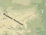
Fig. 2: Indigenous civitates and settlements in Noricum around the mid-1st c. B.C.
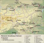
Fig. 3: Important sites of the Roman administration of Noricum (situation at ca. 200 A.D.)
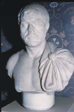
Fig. 4: Bust of a prominent Roman of the Hadrianic period, probably representing the provincial governor Claudius Paternus Clementianus, from the temple precinct at Hohenstein
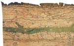
Fig. 5: Detail of the Tabula Peutingeriana with the province of Noricum