See this text in ![]()
The north-west Pannonian corner, the area of the so-called Bratislava Gate (Porta Hungarica, as it was called in the Middle Ages), was in the last century BC settled by a Celtic tribe of Boii. Although the Celtic centres (such as Braunsberg, Bratislava-Devín, Bratislava-Staré mesto) had ceased to exist, one by one, before the turn of the eras, the Celtic population living south of the Danube River survived long into the Roman period. This can be proved by inscribed Celtic names or depictions of female figures wearing native clothes on Roman gravestones.
 The Bratislava-Rusovce settlement excavated in 1995-1996 is one
of the archaeological contributions to understanding the life of native population
in Roman period. The site is located in a field 2.5km south of an equestrian castellum Gerulata (Fig. 1). It cannot be ruled out that there used to exist a road connecting
the fort and the village. Perhaps, it was a diversion from a limes road leading from Carnuntum, through the fort and the civil settlement (vicus) of Gerulata, further southeast to the next auxiliary fort Ad Flexum (present-day
Mosonmagyaróvár in Hungary).
The Bratislava-Rusovce settlement excavated in 1995-1996 is one
of the archaeological contributions to understanding the life of native population
in Roman period. The site is located in a field 2.5km south of an equestrian castellum Gerulata (Fig. 1). It cannot be ruled out that there used to exist a road connecting
the fort and the village. Perhaps, it was a diversion from a limes road leading from Carnuntum, through the fort and the civil settlement (vicus) of Gerulata, further southeast to the next auxiliary fort Ad Flexum (present-day
Mosonmagyaróvár in Hungary).
 The settlement was found in a plain country south of the Danube's
diluvial zone, with low Hainburger and Hundsheimer Berge rising in the north-west and hiding the legionary fortress
and the capital of Upper Pannonia, Carnuntum (about 20km away as the crow flies).
The flat landscape is only divided by longitudinal meanders, the remnants of
long-ago river branches. The settlement was situated on a bank of a one of
these branches called significantly "Deep Brook". Its total area was 4 hectares, of which 0.7 hectare (i.e. a sixth of the total
settlement area) was excavated when a modern motorway was planned to be built
(Fig. 2). The inhabitants seem to have benefited from the site's advantageous
location close to the Roman military forces in Gerulata. Receiving regular
pay, soldiers were probably periodic customers buying the peasants´ produce.
The settlement was found in a plain country south of the Danube's
diluvial zone, with low Hainburger and Hundsheimer Berge rising in the north-west and hiding the legionary fortress
and the capital of Upper Pannonia, Carnuntum (about 20km away as the crow flies).
The flat landscape is only divided by longitudinal meanders, the remnants of
long-ago river branches. The settlement was situated on a bank of a one of
these branches called significantly "Deep Brook". Its total area was 4 hectares, of which 0.7 hectare (i.e. a sixth of the total
settlement area) was excavated when a modern motorway was planned to be built
(Fig. 2). The inhabitants seem to have benefited from the site's advantageous
location close to the Roman military forces in Gerulata. Receiving regular
pay, soldiers were probably periodic customers buying the peasants´ produce.
 The settlement's development distinguishes two phases. In the
earlier stage, dating back to the 2nd century AD, the main settlement feature was a rectangular hut (Grubenhaus) with a saddle roof, supported by two posts located in the middle of the shorter
walls (Fig. 3). The walls were made of sun-dried bricks or earth. Individual
huts only differed in dimensions and location of supporting posts (Fig. 6:1-8).
In this phase, the inhabitants also dug several wells, 3.5m to 4m in depth,
reaching to the present-day level of ground water.
The settlement's development distinguishes two phases. In the
earlier stage, dating back to the 2nd century AD, the main settlement feature was a rectangular hut (Grubenhaus) with a saddle roof, supported by two posts located in the middle of the shorter
walls (Fig. 3). The walls were made of sun-dried bricks or earth. Individual
huts only differed in dimensions and location of supporting posts (Fig. 6:1-8).
In this phase, the inhabitants also dug several wells, 3.5m to 4m in depth,
reaching to the present-day level of ground water.
We may assume that first settlers founded the Rusovce village as early as in the first half of the 2nd century, during the rule of Traianus (98-117) or Hadrianus (117-138). Apart from several pieces dating back to earlier times, the real circulation begins with the coins minted by these two emperors. The huts from the 2nd century AD in Rusovce do not represent Roman provincial housing features, but those of pre-Roman era. It is hard to imagine that they would have been used by colonisers from central, romanised areas of the Empire, or by army veterans accustomed to a much higher lifestyle. Conversely, the two-posted huts were most typical in previous Celtic settlements in the last centuries BC. Their occurrence in Pannonian settlements of the Roman period is considered to be a proof of surviving native population (Gabler 1982, Szőnyi 1995). As regards coinage, the earlier phase ends up in the times of Marcus Aurelius. As the settlement was situated in the hinterland of castellum Gerulata near the provincial border, the continuity disruption could have been caused by the unrest during the Marcomannic Wars (166-180). It needs to be said though that we have not discovered any destructed or burnt layers proving of a direct assault upon the settlement.
 After the Marcomannic Wars ended and peace was restored, the internal
structure of the settlement changed. Earlier huts and some of the wells were
abandoned and filled up and an extensive ditch system across the village was
dug, disregarding earlier structures. Nevertheless, a number of inhabitants
continued using simple huts. As a new element and the most distinctive change
to the earlier phase, two buildings with stone foundations were raised (Fig.
6:9-10). The first one had a simple rectangular layout with two antae in the northeast wall (Fig.4). Roughly in the middle of the structure there
was a base for a column. The building dimensions were 9m times 6.5m. The layout
with antae resembles that of a Roman sanctuary. However, the answer to the question whether
there was a Roman temple in Rusovce remains open. The second structure was
somewhat bigger, with dimensions 11m times 7m, with a base for a column and
a simple heating oven (Fig. 5).
After the Marcomannic Wars ended and peace was restored, the internal
structure of the settlement changed. Earlier huts and some of the wells were
abandoned and filled up and an extensive ditch system across the village was
dug, disregarding earlier structures. Nevertheless, a number of inhabitants
continued using simple huts. As a new element and the most distinctive change
to the earlier phase, two buildings with stone foundations were raised (Fig.
6:9-10). The first one had a simple rectangular layout with two antae in the northeast wall (Fig.4). Roughly in the middle of the structure there
was a base for a column. The building dimensions were 9m times 6.5m. The layout
with antae resembles that of a Roman sanctuary. However, the answer to the question whether
there was a Roman temple in Rusovce remains open. The second structure was
somewhat bigger, with dimensions 11m times 7m, with a base for a column and
a simple heating oven (Fig. 5).
 |
|
The earlier phase of the settlement (2nd century AD) bore significant housing features of native population. The origins of the site Rusovce date back to a period of extensive changes, taking place in the territory of north-west Pannonia in the first half of the 2nd century. In the 1st century AD the Celts in this area formed an autonomous community, civitas Boiorum. In the Hadrianus' times (117-138) the process of civitas' romanisation reached its peak and the territory was divided among the Roman towns Scarbantia, Carnuntum and Mursella (Mócsy 1959, 49, 52, 53). These administrative-territorial changes may have caused migrations of small groups of population and resulted in the establishment of new settlements. On the other hand, the Rusovce settlement has almost exclusively revealed only products made in Roman provincial workshops. These primarily include pottery, where the vessels of Celtic or Laténe D character were missing. They were no more able to compete with the Roman ceramic mass production.
After the Marcomannic Wars, in the late 2nd and early 3rd century AD, the architecture in the Rusovce settlement changed. In the Severian times, the inhabited area was divided by ditches to rectangular areas (plots?). Apart from several huts, the inhabitants also built two buildings with stone foundations. The ties to the local native housing traditions began disappearing, while the settlement started openly adopting the impacts of the generalising Roman culture.
Vladimír Varsik
References:
Gabler, D. 1982: Aspects of the Development of Late Iron Age Settlements in Transdanubia Into the Roman Period (Evidence based upon the excavations at Szakály in southern Hungary). In: D. Gabler - E. Patek - I. Vörös, Studies in the Iron Age of Hungary. BAR Int. Ser. 144. (Oxford 1982) 67ff.
Mócsy, A. 1959: Die Bevölkerung von Pannonien bis zu den Markomannenkriegen (Budapest 1959).
Szönyi, E. 1995: Die einheimische Keramik von der frühkaiserzeitlichen Siedlung Györ-Ménföcsanak. In: Kelten, Germanen, Römer im Mitteldonaugebiet vom Ausklang der Laténe-Zivilisation bis zum 2. Jahrhundert (Brno - Nitra 1995, Hrsgb J. Tejral - K. Pieta - J. Rajtár) 217ff.
Varsik, V. 1999a: Ländliche Besiedlung im Hinterland des Kastells Gerulata. Siedlung der autochthonen Bevölkerung in Rusovce. In: Roman Frontier Studies. Proceedings of the XVIIth Int. Congress of Roman Frontier Studies. Ed. N. Gudea. Zalau 1999, 629-642.
Varsik, V. 1999b: Die Notgrabung einer römischen Siedlung des 2.-3. Jhs. im Hinterland des Kastells Gerulata (vorläufige Ergebnisse 1995-1997). In: Das mitteldanubische Barbaricum und die Krise des römischen Weltreiches im 3. Jh. (Spisy Arch. Ústavu AV ČR Brno 12, Brno 1999. Hrsgb. J. Tejral) 215 ff.
List of figures:
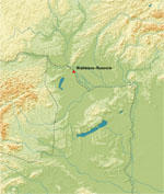
Fig. 1. Auxiliary fort Gerulata and its hinterland.
1 - Roman Gerulata with fort, vicus and cemeteries (U); 2 - Roman rural settlement in native tradition; 3 - Celtic settlements from Laténe-period (after I. Bazovský).
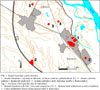
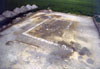
Fig. 2. Bratislava-Rusovce, 2.-3. centuries A. D. Partial plan of excavations.
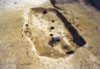
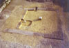
Fig. 3. Bratislava-Rusovce. Hut (Grubenhaus) with dog-burial.
Fig. 4. Building 1 with stone-foundations.
Fig. 5. Building 2 with stone-foundations.
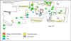
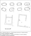
Fig. 6. Bratislava-Rusovce. 1-8 Huts (Grubenhäuser) in native tradition; 9-10 Buildings with stone foundations.