See this text in ![]()
The area of the later province of Upper Germany became part of the Roman Empire during the Gallic Wars of Julius Caesar, in the 50s BC. It originally belonged to the province of Gallia Belgica, but it was separated from it in 16 AD, in the aftermath of the failed attempt to annex Germany east of the Rhine. The area then became a separately administered military district (exercitus), as did its northern neighbour Germania Inferior. The two were then constituted as the provinces of Upper (provincia Germania Superior) and Lower Germany (provincia Germania Inferior) c. 85 AD. In the 1st century (until c. 97 AD) the capital Mogontiacum-Mainz was a double legionary fortress and the largest troop concentration in the province.

The provincial borders changed over time and the true size of the military
district defies definition. If we follow Piny the Elder (Naturalis Historia
4, 17, 31), who served as an officer in the German provinces during his career,
then the territories of the Rauraci, Helvetii, Sequani and Lingones were part
of Gallia Belgica in the mid 1st century AD. Strabo (Geographica 4,3,1) by contrast,
assigns the Lingones to Gallia Lugdunensis in the early 1st century. Either
way, parts of Helvetian and Rauracan territory must have belonged to the Upper
German military district, as the legionary fortress of Vindonissa, in northern
Switzerland, and the forts of the Upper Rhine came under the command of its
Legate. It remains unclear, however, whether the district was just a narrow
strip of land along the Rhine, or a larger territory focussed on the military
bases. The situation certainly changed in the early 70s, with the foundation
of a legionary fortress at Mirebeau, in the territory of the Lingones in Burgundy,
to hold the 8th Legion and vexillations of other Upper German legions. The territory
was now deemed dangerous in the aftermath of an uprising, and probably came
under the control of the Legate of the Upper German district. Certainly it was
incorporated into the formal province at its creation, whether or not it had
been absorbed before, and this is confirmed by the 2nd century geographer Ptolemaios
(2,8). At an unknown point in the 3rd or 4th century, and thus outside the scope
of this study, the territory of the Lingones was transferred to Gallia Ludgdunensis.
 |
Left-bank (western and southern) Upper Germany |
 |
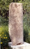
Altar with dedication to the boundary gods |
The western border with Gallia Belgica ran c. 30-50 km west of the Rhine, roughly
parallel to the river, and its detailed course can be traced with varying degrees
of confidence. In Alsace it ran west and included the upper reaches of the Meuse.
From there it turned southwest, now bordering Gallia Lugdunensis, to include
the upper reaches of the Seine and Saône, before reaching the south-western
tip of Lac Leman.
 |
Upper Germany at its greatest extent in the mid 2nd century AD |
Further south, the province bordered on the Alpes Poeninae and then its eastern neighbour, Raetia, with the line running south of the Vierwaldstätter Sees and east of Lake Zürich.
Across the Rhine, the province’s eastern border was moved several times before reaching the line of the Outer Limes in the mid 2nd century. The German wars of Augustus and his successor Tiberius (from the last two decades BC to 16AD) did not lead to settlement activity in this area, and it was only in the Claudian period, around 50AD, that an area was permanently added in the north of the province. Larger annexations occurred under Vespasian, in the early 70s and, under Domitian and Trajan, in the late 1st and early 2nd centuries. The province reached its largest extent under Antoninus Pius c. 150/160, when the frontier was moved a final time onto the line of Outer Limes. The border with Raetia was then continued north of the Rhine to the Schwäbische Alb, along the Rhine/Danube watershed.
|
The occupation of the Upper German territories to the east of the Rhine |
The population of Roman Upper Germany was heterogeneous in many ways. Within the province, settlement differences are apparent, which can be shown to derive from pre-Roman population patterns. These are often hard to interpret, however, because Late Latène settlements have proved hard to identify, for the finds are very unhelpful and there are few diagnostic burial rites.
Until the Late Latène period, the territory of Upper Germany was part of the Celtic oppidum civilisation and the regional centres were mostly town-like oppida on raised ground. Within their walls or banks, craftsmen, houses and ritual sites can be identified, and their trading character is underlined by locally struck coins and a regionally variable level of imports, including some from the Mediterranean. Open, mostly agricultural, settlements also existed on the plains. During the first half of the 1st century BC, invasions by Germanic groups, possibly combined with economic factors, had already led to a partial collapse of this civilisation, particularly in the Rhine valley and the later provincial area east of the Rhine. It was German incursions that drove the exodus of the Helvetii and Rauraci, and their violent repatriation in 58 BC saw the opening of Caesar’s Gallic Wars. German groups under their leader Ariovistus can be found in Gaul from 71 BC, usually in the service of Celtic tribes, and it was Caesar again who moved them onto the far bank of the Rhine after his victory at Mulhouse in Alsace, in 58.
Because of the situation described above, continuity from pre-Roman Celtic times might only be expected in the south and west (and possibly northernmost part) of the later province, in other words the areas of the Helvetii (central Switzerland), the Rauraci (northern Switzerland and southern Alsace), the Sequani (west of the Jura), and the Lingones (Burgundy). These tribes were given self-governing status as civitates by Augustus around the turn of the millennium, with the Helvetii and Lingones gaining the comparatively rare and prestigious rank of civitas foederata: communities closely allied to Rome.
Archaeologically, continuous Celtic occupation can be proven north of a line from Alzey to Worms, although no oppida are known there after the Donnersberg was abandoned in the first half of the 1st century BC. The Aresaces were based around Mainz and the Caeracates were probably also located in Rhine-Hesse, although this remains more uncertain. However, no civitas was founded in this part of the province to subsume these tribes before the late 3rd century AD. Continuous settlement is also proven for Neuwieder Becken.
The situation on the left bank (i.e. west of the Rhine and north of the Rauraci) is very different. The area was originally held by the Treveri and Mediomatrici but, in Roman times, we find the following Germanic tribes in residence: the Triboci in lower Alsace, the Nemetae in the Palatinate and the Vangiones in southern Rhine-Hesse. Their Germanic origin is confirmed by Tacitus (Germania 28) and all three were mentioned by Caesar in the context of Ariovistus’ campaigns in Gaul. This just might be the result of a later emendation to the text, however. It is thus uncertain whether the settlement of these tribes took place in the mid 1st century BC or later, but it would have been unthinkable without at least tacit Roman consent. Certainly, it was complete by the early 1st century AD, at the latest, although the transfer cannot be traced archaeologically because the tribes’ material culture already contained Celtic elements. It is also unlikely that the indigenous population left but, whatever the case, the three tribes became civitates in the 1st century AD.
On the right bank of the Rhine only two tribal groups are known with Germanic
names. The Mattiaci, to the north of the Main, may have been a sept of the Chatti,
who settled in Hessen. Mattiaci territory was formed into a civitas from the
early 2nd century onwards and lay within what had originally been a Celtic area,
which had became germanised by the late 1st century BC. The Germanic Neckarsuebi
settled along the lower Neckar and it is noticeable that their name contained
no traditional elements, but was firmly linked to the new territory. They arrived
in the second quarter of the 1st century AD and, in the early 2nd century their
area too became a civitas. Over the whole of the rest of the province,
none of the local administrative districts contained elements of tribe or group
names, possibly due to a lack of indigenous population, especially in the area
of modern Baden-Württemberg. The southern part of the area might be the Helvetian
wastes mentioned in the literary sources, i.e. ground abandoned by the Helvetii,
probably in the first half of the 1st century BC. Archaeology cannot confirm
a complete depopulation, but it was certainly a thinly settled region, with
no political organisation or cultural identity worth mentioning, and it should
be noted that Tacitus (Germania 29) records the immigration of Gallic
groups into the area in the 1st century.
 |
Celtic and Germanic tribes in the area of the later province of Upper Germany |
 |
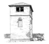
Vesontio-Besançon, Celtic features with defensive wall |
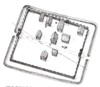 |
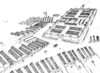
Reconstruction of the Celtic-Roman settlement of Westheim |
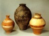 |
Roman period pottery |
 |
|
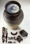
Contents of a Germanic cremation from Diersheim |
Villa Ladenburg-Ziegelscheuer, with remains of the
older Germanic farming settlement |
 |
|
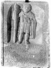
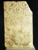
Gravestone of Rufus Coutus , a Helvetian auxiliary
cavalry man |
Gravestone of a praetorian from Fiesole |
Cult and Religion
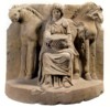 |
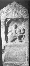
Relief of the Celtic goddess Epona |
 |
Legionary fortress Vindonissa-Winisch |
The actual frontier-watch fell to the auxiliaries, and their forts can be found close to the border, which was itself advanced to the east in several phases between the 1st and the mid 2nd century (see above). The units were mostly recruited from provincials without Roman citizenship, and were made up of infantry (cohorts), cavalry (alae) or mixed units. The most common were c. 500 strong, with units of c. 1000 much rarer and, from the 2nd century onwards, there were also smaller units (numeri) of c. 150. Most 500 strong infantry units had forts of around 1.4 -2.5ha, but there were also much smaller fortlets (some less than 0.1ha), which were used in connection with cross-border traffic. The Limes line itself was equipped with palisades and towers and, later, with a bank and ditch. These installations are currently seen less as a frontier defence, and more as part of a monitored line, which controlled and guided access to the Empire.
 |
 |
 |
Partially reconstructed fort of Saalburg in the Taunus |
Rötelsee fortlet on the outer Limes near Welzheim |
Idealised reconstruction of a watchtower on the Odenwaldlimes
|
 |
Reconstruction of the fort of Zugmantel |
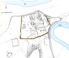
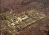
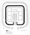
Coloniae
The foundation of two coloniae on Helvetian (Colonia
Iulia Equestris-Nyon) and Rauracan (Colonia
Augusta Raurica-Augst) territory, around the mid 40s BC, came relatively
early. Both were veteran colonies and they were also the first known Roman administrative
measures in the area of the later province. Colonia Iulia Equestris’
position on Lake Leman made it responsible for monitoring the supposedly restive
Helvetians, who thus lost access to the strategically important route into Gallia
Narbonensis. The siting of Colonia Augusta Raurica close to the Rheinknie
(the near right angled turn of the Rhine from west to north) was probably based
on similar strategic considerations. It is unlikely that these foundations led
to immediate settlement activity by Roman veterans, however, for the archaeological
record at both towns only begins around the last (or next to last) decade BC.
In the past, there was some speculation that the original location for the Augst
colony may have been moved from a site at Basel-Münsterhügel, but this cannot
be proven. An Augustan period re-foundation is attested epigraphically and this
would agree well with the archaeological evidence. It remains possible, in both
cases, that the practical implementation of the settlement’s foundation was delayed
by several decades by the Roman civil wars and the later annexation of the Alpine
region.
 |
|
|
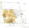
Plan of the colonia Augusta Raurica-Augst |
Colonia Augusta Raurica-Augst, View of the
town |
Plan of the colonia Iulia Equestris-Nyon |
Colonia Helvetiorum-Avenches became the second colony on Helvetian territory in 70 AD, although this time it was a case of the capital of the civitas Helvetiorum being given a higher rank. The award differed from the two earlier foundations in that it is unclear whether a veteran colony was involved and so it is hard to say if we should expect new settlers, or just a purely legal change of status. Strategic considerations were probably irrelevant here. Instead, the personal relationship between the Emperor Vespasian and the Helvetians is more likely to have been decisive, as his father had had business interests in the area.
 |
 |
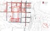
Plan of Aventicum-Avenches |
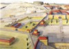
Aventicum-Avenches, Reconstruction of the
western quarter |
From early on, the colonies’ architecture gave them the appearance of deeply Romanised communities, although it remains unclear how far the veterans added to this impression. Few inscriptions survive from Augst and Nyon, but the epigraphic evidence from Avenches records an almost exclusively indigenous urban population. It is readily apparent that the distribution of colonies was biased towards the south of the province: an area that remained part of Gallia Belgica until Flavian times. The province also lacked the close spatial relationship between coloniae and legionary fortresses that can be seen elsewhere. For they were not set in the legions’ immediate vicinity, as they were on the Danube, nor in abandoned fortresses, as in Britain.
 |
The coloniae of Upper Germany |
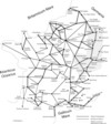
The imperial roads (viae publicae) are confirmed as important transport arteries by literary sources. The itinerarium Antonini, for example, was a list of roads, and the settlements through which they passed. It dates to the early 3rd century and continued to be updated into the 4th. The long distance thinking behind the work is apparent in entries such as that for the road from Milan to Mainz (iter a Mediolano per Alpes Poeninae Mogontiacum). There is also the tabula Peutingeriana, a preserved road map that continued to be copied in the Middle Ages. It was originally drawn in the 4th-5th century, but sometimes reflects older positions. It is a schematic of the links between different places that does not try to reproduce the topography. Over 100 inscribed milestones are also known from the province, usually naming the Emperor and the distance to the nearest administrative centre. These column-like monuments were usually 2m high and positioned alongside the road. The 1st century inscriptions still appear to record genuine building work, but in the course of the later 2nd century they became honorary in nature, with no direct link to construction. The distances are given in miles (1,48 km) or Leugae (2,22 km), a Celtic measurement of distances.
The routes over the Alps from northern Italy, continued north to the provincial capital Mainz, and then on to Lower Germany. Several more came from the west, through Gaul, towards Switzerland or the Rhine, and roads to the east could run south of the Rhine or through the provincial area beyond it. The first Roman roads were built in the reign of Augustus, from the late 1st century BC onwards, but the conquest of the cross-Rhine areas, around 75AD, provided a great improvement in east-west communications that allowed the construction of roads from Arae Flaviae-Rottweil to Argentorate-Strasbourg and from Lopodunum-Ladenburg to Mainz.
In addition to the roads known from epigraphic or literary sources, further examples existed that are not so recorded, and which had a different legal status. These were often of regional importance and provided links between the principle routes. Sections of Roman road have been found by excavation or with the aid of aerial photography, and some are still followed by modern successors. The most important roads were c. 15-18m wide and normally consisted of a central gravelled carriageway, two flanking earth tracks, and side ditches. The carriageway’s construction depended on the subsoil, but it usually involved several layers of sand and gravel, which could be underpinned by logs in wet terrain. More sophisticated solutions could be adopted in difficult terrain: for example the rock cutting at Pierre Pertuis. This lies on the road from Petinesca-Studen to Augusta Raurica-Augst in Switzerland and had an inscription by an official from Aventicum-Avenches that dates to c. 200AD.
|
|
 |
|
Schematic of the known long-distance roads in the
Gallic provinces |
Remains of a Roman road near Burladingen |
Milestone from Köngen |
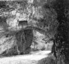
Rock cutting and tunnel for the road at Pierre Pertuis
with inscription |
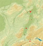
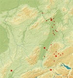
| Reconstruction of a section of the Rhine bridge at Koblenz, dated 49 AD |
Other bridges in the province had longer (in some cases centuries long) histories. The largest linked Mogontiacum – Mainz with Castellum Mattiacorum-Mainz Kastel and a dendro-date suggests a timber-built origin in 28 AD. The 420m bridge was later remodelled with 31 stone piers resting on over 600 timber piles, and with a wooden superstructure for the carriageway. Repairs can be dated to the 3rd century on the basis of small inscriptions. The Mainz bridge is also the only one in Upper Germany for which pictorial evidence has survived, in the form of the “Lyon lead medaillon”: a trial piece for a large gold coin dating to around 300. Remains of further stone Rhine bridges, which probably date to the first three centuries AD, have been found at Cambete-Kembs and Augusta Raurica-Augst, and others probably existed, for example in the vicinity of the Argentorate-Straßburg legionary fortress.
|
|
 |
Reconstruction of the timber pilings for the Mainz
bridge in the 19th century |
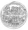
Drawing of the ‘Lyon lead medaillon’ with depiction
of the Mainz Rhine bridge, c. 300AD |
Large bridges are also known from the Rhine’s tributaries: the Nahe, Main, Neckar and Jagst, although the attribution of some to the Roman period remains unproven thanks to a lack of dendro dates. A building date of 134 AD is known for a stone pier of the Main bridge at Großkrotzenburg, and the Main bridge at Bingen dates to 77. The 84m timber bridge accross the Broye at Le Rondet (Switzerland) was also built in 77, and it was refurbished in 229.
 |
Reconstruction of the timber bridge across the Broye near Le Rondet |
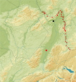
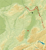
Upper Germany was largely dominated by its rivers. The Rhine, and tributaries such as the Main and Neckar, were of special importance, and only the western part of the province had rivers that led to the Mediterranean and Atlantic. Significantly, part of the provincial boundary ran along the Rhine/Danube watershed. These river systems were economically important, as they offered a cheaper alternative to land transport, and original fragments of ships are known from Mainz, from the Rhine close to Strasbourg, from the Lac de Morat and from the Lac de Neuchâtel in Switzerland. The most important cargo boat types were praams and flat-bottomed barges, and the box-shaped hulls of such vessels rose up at both bow and stern, to allow the boats to be landed in the absence of proper harbour quays. An original length of 40m, and a beam of 5m, can be reconstructed for a pram found at Mainz, whose timbers have a (dendro) felling date of 81AD. Other 1st and 2nd century barges from Yverdon and Bevaix were about 20m long. We have epigraphic evidence for bargemen (nautae), along with their guilds (collegia), which could be restricted to particular rivers or lakes. Almost no quays are yet known, however, although they presumably existed along the waterfronts of every significant settlement. It is also worth mentioning that a 1,300m long canal linked Colonia Aventicum-Avenches with a river harbour on the Lac de Morat.
 |
 |
 |
 |
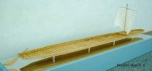
Model of a pram, based on 1st century finds from Mainz |
Remains of 2nd century barge from Bevaix on the Lac
de Neuchâtel |
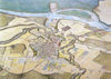
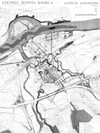
Aventicum-Avenches c. 180 AD, with harbour
and canal |
Grave monument of the bargeman Blussus from Mogontiacum-Mainz |
The province of Germania Superior was only created in 85AD, but the military district had existed since 16AD, albeit without the later province’s southern and western parts. The German wars dominated events between 13BC and 16AD but, ultimately, led to the abandonment of plans to conquer areas to the east of the Rhine (at least for some time), and the creation of the new province. Some Trans-Rhine areas were eventually annexed in several stages between 73 and 160. Within the province, a markedly different development pattern is apparent between the southern and western zone on the one hand, and the northern and cross-Rhine areas on the other. While the former were continuously controlled, from pre-Roman times, by long-established Celtic tribes, the latter were submitted to Germanic immigration from the 1st century AD onwards.
Until the province was founded, its southern and western territories belonged to Gallia Belgica, and civilisation had made rapid progress. The only colonia foundations lay in this area, and we find frequent evidence for an Imperial cult in its communities from early on. By contrast, the development of the northern area was strongly linked to the military. Thus Mogintiacum-Mainz, the home of a legionary fortress, had no independent legal civilian status until the later 3rd century although, even so, it was the site of annual celebrations in honour of Augustus’ stepson Drusus and his son Germanicus. Uprisings, such as the revolt of the Helvetians and Lingones in 69AD, show that Roman rule was far from secure even long after the conquest. Moreover, religion and material culture attest to the survival of local elements into the 3rd century. Its position made the province a north-south and east-west highway for both troop movements and goods transport, and this is reflected in a well-developed road network and important river routes.
Text: Thomas Schmidts
Translation: Birgitta Hoffmann
B. Arnold, Architecture navale en Helvetie a l'epoque romaine: les barques de Bevaix et d'Yverdon. Helvetia Archaeologica, 20 (77), 1989, 2-28.
D. Baatz (Hrsg.), Die Römer in Hessen (Stuttgart2 1986).
D. Baatz (Hrsg.), Der römische Limes. Archäologische Ausflüge zwischen Rhein und Donau (Berlin3 1993).
S. Bauer, Römische Floßhölzer und Fässer aus Mainz. Auf den Suren der Flößer und Böttcher in Obergermanien. In: Neue Forschungen zur römischen Besiedlung zwischen Oberrhein und Enns. Schriften der Archäologischen Staatssammlung 3 (Remshalden-Grunbach 2002) 207-221.
S. Bolliger, Untersuchungen zum römischen Straßennetz in der Schweiz. Inventar der römischen Siedlungen und Straßen. Bonner Jahrbücher 202/203, 2002/2003, 237-266.
M. Carroll, Römer, Kelten und Germanen. Leben in den germanischen Provinzen Roms (Darmstadt 2003).
H. Cüppers (Hrsg.), Die Römer in Rheinland-Pfalz (Stuttgart 1990).
H. Cüppers, Die Trierer Römerbrücken. Trierer Grabungen und Forschungen V (Mainz 1969) 184-193.
W. Drack/R. Fellmann, Die Römer in der Schweiz (Stuttgart 1988).
St. Fichtl, La ville celtique: Les oppida de 150 av. J.-C. à 15 ap. J.-C. (Paris 2005).
Ph. Filtzinger/D. Planck /B. Cämmerer (Hrsg.), Die Römer in Baden-Württemberg (Stuttgart3 1986).
F. Fischer, Südwestdeutschland im letzten Jahrhundert vor Christi Geburt. In: Archäologie in Württemberg (Stuttgart 1988) 235-250.
P. Flotté/M. Fuchs, Le Bas-Rhin. Carte Arch. Gaule 67/1. (Paris 2000).
R. Frei-Stolba, Recherches sur les institutions de Nyon, Augst et Avenches. In : Cités, municipes, colonies. Les processus de municipalisation en Gaule et en Germanie sous le Haut Empire romain (Paris 1999) 29-95.
L. Flutsch / U. Niffeler / F. Rossi (Hrsg.), Die Römerzeit in der Schweiz. Die Schweiz vom Paläolithikum bis zum frühen Mittelalter (SPM) 5 (Basel 2002).
A. R. Furger, Die urbanistische Entwicklung von Augusta Raurica vom 1. bis zum 3. Jahrhundert. Jahresbericht aus Augst und Kaiseraugst 15, 1994, 29-38.
E. Frézouls, Les villes antiques de la France. II. Germanie Supérieure. 1. Besançon, Dijon, Langres, Mandeure. (Strasbourg 1988).
J. Heiligmann, Römische Schifffahrt in Südwestdeutschland. In: Einbaum, Lastensegler, Dampfschiff: Frühe Schifffahrt in Südwestdeutschland. ALManach 5/6, 2000/2001, 93-108.
H. E. Herzig. Untersuchungen zum römischen Straßennetz in der Schweiz. Der Versuch einer Mikrostraßengeschichte. Bonner Jahrb. 202/203, 2002/2003, 227-236.
P. Haupt /Pare, Die jüngere Latènezeit im Alzeyer Raum: zum Schicksal der keltischen Bevölkerung am nördlichen Oberrhein. In: Bevor die Römer kamen. Kelten im Alzeyer Land. Alzeyer Geschichtsblätter Sonderheft 17 (Mainz 2003).
O. Höckmann, Reste römischer Prähme und Hafenanlagen vom Kappelhof in Mainz. Mainzer Archäologische Zeitschrift 2, 1995, 131-166.
A. Johnson, Römische Kastelle des 1. und 2. Jahrhunderts n. Chr. in Britannien und in den germanischen Provinzen des Römerreiches (Mainz 1987).
P. Jud (Hrsg.), Die spätkeltische Zeit am südlichen Oberrhein. Le Rhin supérieur à la fin de l'époque celtique. Kolloquium Basel 1991 (Basel 1994).
M. Kemkes/J. Scheuerbrandt/N. Willburger, Am Rande des Imperiums Der Limes - Grenze Roms zu den Barbaren (Stuttgart 2002).
M. Klee, Der Limes zwischen Rhein und Main (Stuttgart 1989).
M. J. Klein (Hrsg.), Die Römer und ihr Erbe. Fortschritt durch Innovation und Integration. Ausstellungskatalog Mainz (Mainz 2003).
G. Lenz-Bernhard, Lopodunum III. Die neckarswebische Siedlung und Villa rustica im Gewann "Ziegelscheuer". Eine Untersuchung zur Besiedlungsgeschichte der Oberrheingermanen. Forsch. u. Ber. Vor- u. Frühgesch. Baden-Württemberg 77 (Stuttgart 2002).
G. Lenz-Bernhard/H. Bernhard, Das Oberrheingebiet zwischen Caesars Gallischem Krieg und der flavischen Okkupation (58 v.-73 n.Chr.). Eine siedlungsgeschichtliche Studie. Mitteilungen des Historischen Vereins der Pfalz 89, 1991.
H. Nesselhauf, Die Besiedlung der Oberrheinländer in römischer Zeit. Badische Fundberichte 19, 1951, 71-85.
D. Planck (Hrsg.), Imperium Romanum. Roms Provinzen an Neckar, Rhein und Donau. Ausstellungskatalog Stuttgart (Stuttgart 2005).
D. Planck/W. Beck, Der Limes in Südwestdeutschland (Stuttgart 1987).
D. Planck/S. von Schnurbein, Der römische Limes in Deutschland (Stuttgart 1992).
M. Th. Raepsaet-Charlier, Les instutitions municipals dans les Germanies sous le Haut Empire. In: Cités, municipes, colonies. Les processus de municipalisation en Gaule et en Germanie sous le Haut Empire romain (Paris 1999) 271-352.
M. Th. Raepsaet-Charlier, Gallien und Germanien. In: Rom und das Reich in der Hohen Kaiserzeit 44 v. Chr. – 260 n. Chr. II. Die Regionen des Reiches (München/Leipzig 2001).
M. Rathmann, Untersuchungen zu den Reichsstraßen in den westlichen Provinzen des Imperium Romanum. Beihefte der Bonner Jahrbücher 55 (Mainz 2003).
O. Schlegel, Germanen im Quadrat. Die Neckarsueben im Gebiet von Mannheim, Ladenburg und Heidelberg während der frühen Kaiserzeit. Internationale Archäologie 34 (Rhaden/Westf. 2000).
St. G. Schmid, Die Bauinschrift eines Bades und der Kaiserkult in Augusta Raurica – Bemerkungen zu CIL XIII 5266, CIL XIII 5274 und CIL XIII 5275. In: Tituli Rauracenses 1. Testimonien und Aufsätze. Forschungen in Augst 29 (Augst 2000) 95-106.
H. Schönberger, Die römischen Truppenlager der frühen und mittleren Kaiserzeit zwischen Nordsee und Inn. Ber. RGK 66, 1985, 321–497.
M. P. Speidel/B. Scardigli, Neckarsueben (Suebi Nicrenses). Archäologisches Korrespondenzblatt 20, 1990, 241-207.
L. Vaxelaire/Ph. Barral, Besançon: de l'oppidum à la ville romaine. In: La naissance de la ville dans l'antiquité (Paris 2003) 239-261.
F. Vittinghoff, Die politische Organisation der römischen Rheingebiete in der Kaiserzeit. In: Civitas Romana. Stadt und politisch-solziale Integration im Imperium Romanum der Kaiserzeit (Stuttgart 1994) 66-88 (Abdruck eines Beitrages von 1976).
L. Wamser/Ch. Flügel/B. Ziegaus (Hrsg.), In: Die Römer zwischen Alpen und Nordmeer. Schriftenreihe der Archäologischen Staatssammlung 1. Ausstellungskatalog Rosenheim (Mainz 2000).
G. Wieland, Die Spätlatènezeit in Württemberg. Forschungen zur jüngeren Latènekultur
zwischen Schwarzwald und Nördlinger Ries. Forschungen und Berichte zur Vor-
und Frühgeschichte in Baden-Württemberg 63 (Stuttgart 1996).
G. Wieland, Keltische Viereckschanzen. Einem Rätsel auf der Spur (Stuttgart
1999).
E. B. Wightman, Lugdunensis, Belgica or Germania superior? In: Studien zu den Militärgrenzen Roms. Vorträge des 10 internationalen Limeskongresses (Köln 1977) 207-217.
J. Wilmanns, Die Doppelurkunde von Rottweil und ihr Beitrag zum Städtewesen in Obergermanien. In: Epigraphische Studien 12 (Köln, Bonn 1981) 1-182.
H. Wolff, Einige Probleme der Raumordnung im Imperium Romanum, dargestellt an den Provinzen Obergermanien, Raetien und Noricum. Ostbairische Grenzmarken 28, 1986, 152-177.
H. Wolff, Die römische Erschließung der Rhein- und Donauprovinzen im Blickwinkel ihrer Zielsetzung. In: Römische Inschriften – Neufunde, Neulesungen und Neuinterpretationen. Festschrift H. Lieb (Basel 1995) 309-340.
W. Zanier, Funde der keltischen Viereckschanzen bis in frühe römische Kaiserzeit? Fundber. Baden-Württemberg 28/1, 2005, 207-236.