See this text in ![]()
Roman control over the area of the later province of Germania Inferior began during the Gallic wars of Julius Caesar and was secured by a campaign against the Eburones (see below) in 53 BC. As yet, however, there was no fortification of the river frontier. The area was originally part of the province Gallia Belgica, but was detached from it in 16AD and formed into a military district (exercitus). The same happened in the adjoining area to the south, Germania Superior, and both were constituted as provinces (provincia Germania Inferior and provincia Germania Superior) in 85 AD.
 |
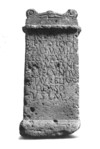
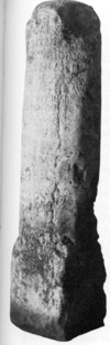
Boundary marker from Menden |
The earliest army base on the Rhine left bank dates to c. 20 BC and the following
decades saw Augustus’ German wars, which brought military operations and additional
bases, particularly along the Lippe. However, the plan to create a German province
stretching to the Elbe was wrecked by the destruction of Varus’ three legions
in battle in 9AD and any remaining plans for annexations east of the Rhine were
abandoned by the Emperor Tiberius in 16 AD. Henceforth, the Rhine formed the
limit of Roman rule, although images of a modern river frontier would be misplaced,
as the Roman army continued to use areas on the right bank, for example for
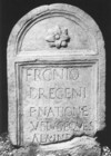
pasture. This much is documented in literary sources and by a boundary marker
from Menden, opposite Bonn, but we do not know whether Rome claimed right bank
land along the entire river, or only in particular sections.
 |
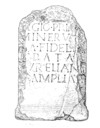
Altar with dedication to the boundary gods |
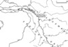
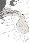
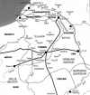
The boundary then ran through the Eifel, roughly between Marmagen and Gerolstein, where milestones count from colonia Claudia ara Agrippinensium-Köln and from Augusta Treverorum-Trier in the province of Gallia Belgica.
The province’s western boundary currently remains undefined and it is still disputed whether the Tungri, west of the Meuse, belonged to Lower Germany or Gallia Belgica during the 1st - 3rd centuries AD. In late antiquity, we know that they belonged to the former, under its then current name: Germania II, but this is not necessarily proof of the earlier position. If the Tungri were part of the province, then it included large tracts of land to the west of the Meuse but, if not, then the province would lie between the Rhine and the Meuse, with a comparatively narrow strip of land on its Western bank Until further finds allow the status of this tribe to be better defined, it thus seems best to omit them from consideration, especially as a change in their status at some point during the first three centuries AD cannot be ruled out.
 |
 |
|
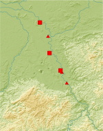
The province of Lower Germany in the Roman period, with a
hypothetical boundary excluding the Tungri |
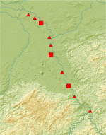
The province of Lower Germany in the Roman period, with
a hypothetical boundary including the Tungri |
The composition of the population of southern Lower Germany was influenced by several planned resettlements of tribal territory in the early phase of the Roman occupation. Large sections of the local population where thus immigrants from east of the Rhine.
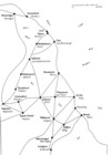
The southern part of the later province first appears in the historical record during the Gallic Wars of Julius Caesar. Most of the area was settled by the Eburones, who Caesar lists among the Germans settling on his side of the Rhine (Germani cisrhenani). Their tribal lands cannot be defined with confidence, but they bordered on the Treveri in the south, and must have covered parts of the Eifel and the adjoining loess belt to the north. They reached areas to the west of the Meuse, but it remains particularly unclear how far their territory extended to the east, and whether it reached the Rhine. The tribe became the target of large-scale military operations in 53 BC, after an uprising during the winter of 55/54, and part of the population was captured or killed. It remains debateable whether the tribe was completely annihilated, as is sometimes suggested, but its name certainly dropped out of the historical record. The 1st century BC settlement pattern can only be partially assessed from an archaeological perspective, as the finds are not conducive to detailed chronological analysis, but it seems that some sites were abandoned before Caesar’s campaigns. There appears to have been a reduced level of settlement in the second half of the 1st century BC, and pollen profiles from the Jülicher Börde (the loess area around Jülich), suggest that the reduction took place in mid century.
|
|
 |
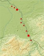
| Tribes during Caesar’s Gallic wars in 56/55 BC |
Hambach-Niederzier 382 |
The Germanic Ubii were originally settled on the right bank of the Rhine, but it has not yet been possible to pinpoint the exact location of their ancestral tribal lands bordering on the Rhine. They settled in an area close to the river between the Sieg and the Main that, so far, can also not be narrowed down further, although it is possible that the oppidum on the Dünsberg played a crucial role. Because of their Rhineland location, the Ubii showed strong cultural affinities to the Celtic world and, if it was associated with the tribe, the finds from the Dünsberg would bear this out, as does their adoption of the habit of striking coins. According to the historical record, the Ubii were resettled by Agrippa, presumably during one of his governorships of Gaul in 38/37 and 19/18 BC, and the tribe was linked to Rome by an alliance. It has been proposed on the basis of archaeological evidence that members of the tribe may have infiltrated gradually onto the left bank, but it remains doubtful whether the Romans would have permitted such a strategy. On current evidence, the most likely scenario would be a resettlement in 19/18 BC. Some idea of both their original area and their new territory can be gleaned from literary sources and the distribution of coins in the Celtic tradition, and it is possible that future archaeological finds will be able to modify or further refine our analysis. It is not yet clear where the tribe’s central place may have been after the relocation, although settlement traces in Bonn and Nöevenich have both been interpreted in this way. The oppidum Ubiorum-Köln, which was founded in the 1st decade AD and formed the basis for the later Colonia Claudia Ara Agrippinensium (CCAA), shows no indications of native influence. Nevertheless the town is likely to have served from its beginning as the administrative centre for the self-governing tribe (civitas Ubiorum).
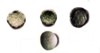 |
Possible ‘Ubian’ coinage from Mariaweiler |
The Cugerni (or Guberni) are known from the Augustan period onwards, in the area of the later colonia Ulpia Traiana (CUT)-Xanten, and the adjoining area between the Rhine and the Maas to the south. For the most part, these were probably resettled groups from the German Sugambri, which were originally located in the area of the Ruhr and Sieg and, historically, we know of the resettlement of 40,000 Germans from the Rhine right bank in 8BC. As the Sugambri are then never mentioned again, it is very likely that they were the Germans involved. It remains unclear whether the Cugerni were originally a sub-tribe of the Sugambri or if the settlers acquired a new name on the other side of the river. The latter is certainly possible and would find a parallel in the Batavians. It is also feasible that local resident German groups formed a new unit with the arriving settlers. Older publications suggest that Xanten’s predecessor settlement formed the administrative centre of the civitas of the Cugerni, but new research makes this seem unlikely. It must remain open, therefore, if and when the Cugerni formed a self-governing tribal community within the Roman Empire.
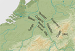 |
Tribal territories c. 8BC |
The neighbouring Baetasii were closely linked to the Cugerni, and probably settled south of the Niers. Imperial guardsmen calling themselves Traianensian Baetasii are known from the 2nd/3rd centuries AD, which suggests an administrative unity between this tribe and the Colonia Ulpia Traiana. Their origin remains uncertain, as does the question of whether they had already formed their own civitas in the 1st century AD.
The home of the Sunuci lay west of the Rhine, in the area around Aachen. They
may have been remnants of the Eburones, but this has yet to be proven and the
same is true of the Sopeni, who were settled around Zülpich. As with the Cugerni,
it is doubtful whether these groups had their own self-governing civitates.
The southern part of the province had several centres that had positive effects on the acculturation of the local population: two coloniae and a legionary fortress. Even in the 1st century BC, large parts of the population became romanised, as is shown by the known Latin inscriptions. This process was furthered by the recruitment of local people into auxiliary units, who gained Roman citizenship at the end of their period of service. Cohorts of Ubii, Cugerni and Baetasii are attested epigraphically, and local recruitment from the tribes named can be assumed, at least during the 1st century. Moreover, Ubii are known both from other contemporary auxiliary units and the Imperial bodyguard. There are also Sugambrian cohorts known, which may reflect the resettled tribes (see above) and the Ubii, in particular, remained loyal to Rome during the Batavian uprising of 69AD.
 |
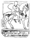 |
Funerary stela of the Ubian, Fronto, from Mainz-Weisenau |
Gravestone of theUbian horseman Albanus from Chalon-sur-Saône
(F) |
In the countryside, local traditions can be identified in dress and religious practice, and at a few settlements, such as Weeze, their existence can be documented from pre-Roman times. In addition, local building traditions, such as long-houses with integrated stables, can be seen on Roman period farms, e.g. Pulheim-Brauweiler and Jüchen-Hochneukirch. The impression that villas were rarer in Germania Inferior is also worth noting, and may suggest a predominance of local traditional settlement, as can be shown for the Dutch part of the province. Finds of 1st century AD graves for a local German population are known from the area of what became Colonia Ulpia Traiana –Xanten. There does not, though, appear to have been a settlement there, as is proposed in older literature, but rather a sequence of auxiliary forts with their associated civilian settlements.
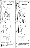 |
Settlement in Pulheim-Brauweiler |
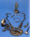
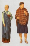
Funerary reliefs and dedications from the Ubian tribal territories document
local female dress into the early 3rd century AD. This is characterised by a
large bonnet and a shawl held together with a brooch placed below the breast.
This ‘bonnet fashion’ may have been limited to married women. During the 1st
century AD chains and large disc pendants were also worn, and these are known
elsewhere as part of indigenous Celtic fashion.
 |
 |
1st century AD hoard from Bonn |
Drawn reconstruction of local male and female fashion
|
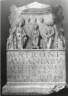
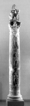
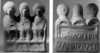
Local religious elements were particularly long-lived and a typical example in southern Germany was veneration of the Matrones. These were mother goddesses with Celtic or German epithets. They occur frequently in dedications and were depicted on reliefs and terracotta statuettes, wearing local dress. Jupiter columns with their crowning gods were also based on local traditions, and the south of the province was one of their distribution foci.
 |
 |
Dedication to the Matrones Aufaniae |
|
 |
|
| Terracotta statuette with three matrones |
Jupiter column from Erkelenz-Kleinbouslar |
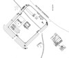
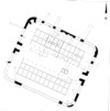
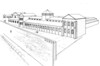
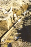
Lower Germany had some of the highest troop concentrations of any of the Roman Empire’s frontier provinces. After the German wars came to an end in 16 AD, the forts normally lay along the Rhine. In the 1st century, legionary fortresses, containing one or two legions, could be found on the left bank at Vetera-Xanten, Novaesium-Neuss, and near the oppidum Ubiorum-Köln (not all were in use at the same time) whilst, from the early second century, there were single legions at Vetera-Xanten and Bonna-Bonn. The 23.9ha legionary fortress at Novaesium-Neuss is almost completely known, following excavations in the 19th century.
 |
 |
Legionary fortress of Novaesium-Neuss |
Double legionary fortress of Vetera I in
Xanten-Birten |
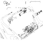
Auxiliary forts have also been identified along the Rhine, between the legionary
fortresses. Unlike to the legionaries, members of these units did not usually
have Roman citizenship and, instead, received it on completion of their service.
Forts are known for both cavalry (alae) and infantry units (cohorts), which
were usually 1-3.5 ha in area. There were also a few fortlets, which could be
less than 0.2 ha, although these have been found only rarely so far.
 |
 |
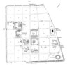
Auxiliary fort of Gelduba-Krefeld-Gellep |
Roman fortlets at Duisburg-Rheinhausen |
One unusual site was the 3.7ha base of the German fleet (Classis Germanica)
at Cologne-Alteburg, and the fleet seems to have transported building materials
as well as mounting river patrols.
 |
Fleet base Köln-Alteburg |
The only coloniae in the province, Colonia Claudia Ara Agrippinensium (CCAA)-Cologne and Colonia Ulpia Traiana(CUT)-Xanten, were both located in the South, and both were veteran colonies. The number of retired soldiers settled there remains unknown, but calculations range from 1,000-2,000 persons, plus further citizens in the form of members of their families. The local population was not initially granted citizenship, however, apart from selected local dignitaries who received it directly from the Emperor.
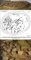
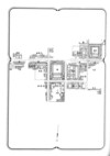
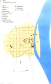
CCAA was founded in 50AD by the Emperor Claudius, in honour of his wife Agrippina, who was born there in 15/16 AD. The settlement, which was previously known as Oppidum Ubiorum, had existed since the first decade AD and was already a centre for the Imperial cult, and furnished with stone buildings. In the decades following the creation of the colonia, the town was systematically developed. It grew to a size of nearly 100ha and acquired a high level of Romanisation, as is documented by its buildings and monuments, and we have a comparatively large number of inscriptions that mention its civic officers (decuriones). In 85AD it became the provincial capital and thus the residence of the governor of Lower Germany. It was also the cultural and economic centre of the province, probably helped by the presence of the rapidly Romanising Ubii and their elite.
 |
 |
 |
CCAA-Köln, |
CCAA-Köln, end 2nd/early 3rd century AD |
CCAA-Köln, Reconstruction of the governor’s palace |
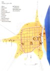
Xanten, on the other hand, was only founded by Trajan in 100/105 AD and shows no signs of any predecessor settlement comparable to Oppidum Ubiorum. After its creation, and especially in the 120s, the town developed numerous large buildings and a city wall. Its individual structures are better known than Cologne’s, as the colonia remained free of modern development, and could thus be studied by large-scale excavations. At 73ha it belongs amongst the province’s larger settlements, but why it was chosen as a colonia site, remains unclear. Despite its many monumental buildings, it never reached the importance of CCAA, something also mirrored in its territory, and this may have been partly due to the lower political and economic significance of the local Cugerni.
 |
 |
CUT -Xanten |
Harbour temple in the Archäologischen Park Xanten |
The road network of southern Lower Germany developed in response to military and economic needs. A north-south running “Limesstrasse” linked the military installations and civilian settlements along the Rhine, and several more roads branched off this main artery into neighbouring Gallia Belgica, especially towards Trier and Reims. These were Imperial roads (viae publicae), i.e. important official transport corridors. The flat landscape allowed them to run straight for long distances and sections of the current Bundesstrassen between Elsdorf and Jülich, and from Krefeld to Xanten lie directly on top of them. There were also more minor roads, with no official function, which linked into this Imperial system.
Two written sources add further important information. The first is the Itinerarium Antonini, a list of places that lay along specified roads. It originally dates to the 3rd century, but was amended in the 4th. The second is the Tabula Peutingeriana, a heavily schematised map of the road network and its associated resting points. It does not reflect conditions at any specific point in time for, although it is often dated to the 4-5th century, it appears to record older positions. The known example was copied in the Middle Ages.
Milestones were often raised along Roman roads to give the distance to the closest town or administrative centre, but they are comparatively rare in Lower Germany. Very few are known from the southern part of the province, but these count from CCAA-Köln. The distances are usually given in Leugae (2.22 km), a Celtic measurement, but miles (1.48km) do occasionally occur. According to the imperial titulature given on the stones they date from the 2nd-4th centuries, but milestones tended to be honorific monuments by this time, whilst 1st century examples are more likely to reflect actually building work.
Roman roads have also been revealed in numerous archaeological excavations.
The cambered road was made of layers of gravel and could be 5-8m wide. At its
sides it was flanked by a greensward and roadside ditches, so that an imperial
road could total 18-25m wide. Paved roads of flagstones, similar to those known
in the Mediterranean provinces, have been found at Cologne.
 |
 |
Imperial roads of Germania Inferior |
|
 |
|
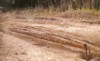
Roman Limesstrasse Moers-Asberg |
|
|
|
|
Milestone from Zülpich-Hoven |
Roman basalt paving stones near Köln |
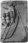
No Rhine bridges are known in Germania Inferior before the 4th century AD. The right bank of the Rhine was under Roman control (see above) and in use by the military, but at first no bridging points were created, similar to those known from Upper Germany. The 400m long bridge linking Cologne with the fort of Deutz was built around 310AD, whereas the bridge across the Meuse at Maastricht was already built in the 1st century AD.
In the Roman period the Rhine was the province’s most important transport
corridor, along which we find not just the towns CCAA-Köln and CUT-Xanten,
but also most of the military installations and their associated civilian settlements.
Harbour installations are known, or must be presumed, at all of these and the
Romans probably also used tributaries, such as the Rur and Erft for water transport.
Security was maintained on the river by the fleet, using special military craft
stationed at Köln-Alteburg (see above), but heavy good transport employed flat-bottomed,
praam type barges. These could displace over 30 tonnes, but their shallow draft
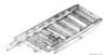
allowed them to be used even in low water. Two wrecks of this type have been
found near Xanten. At Xanten-Wardt, the timbers of a 15m long praam (half is
preserved) were felled in 95AD. By contrast the Xanten-Lüttingen boat, which
was originally twice as long, dated to 275. A further 1st century praam has
been found in the Roman harbour of Cologne, and the town has also produced a
fragmentary relief showing the poop of a barge with a rudder. The importance
of rafting is difficult to quantify, but it has been possible to prove that
building timbers from Xanten came from neighbouring Upper Germany and reached
their destination as rafts
 |
 |
 |
| Drawn reconstruction of the wreck of Xanten-Wardt |
||
 |
||
CCAA-Köln, Roman city wall, with timber quay in front of it |
CCAA-Köln, Remains of a barge |
CCAA-Köln, Relief with depiction of the poop
of a Roman barge |
Despite the fact that Lower Germany was conquered during Caesar’s Gallic Wars, Roman influence on its infrastructure and settlements can only be detected from around the turn of the millennium onwards. As part of the province of Gallia Belgica, the military bases on the Rhine served as launch sites for the Emperor Augustus’ German wars. However, with the end of these dreams of expansion, in 16AD, the area was separated from the rest of the province and became a military district (exercitus Germaniae inferioris), like Upper Germany. The creation of a regular province only took place around 85AD. The southern part of the province was dominated by the strong military presence along the Rhine. The largest civilian sites were the two veteran colonies: Colonia Claudia Ara Agrippinensium (CCAA)-Köln and Ulpia Traiana(CUT)-Xanten, founded in 50 and 100 respectively, with the former as the provincial capital and the source of Romanisation for the surrounding area.
All of the known tribes from southern Upper Germany are considered to be Germanic. Caesar’s attack on the Eburones led to at least a reduction in settlement density in the area and the Roman administration used this opportunity to conduct a systematic resettlement by German groups from the right bank of the Rhine. The most important of these, the Ubii, probably arrived around 19/18 BC in the Cologne/Bonn area, whilst the Cugerni reached Lower Germany around 8BC. The local population and their traditions can be detected in rural settlements by their dress and religious habits. According to our current understanding, however, it is unlikely, that native settlements served as predecessors to the Roman coloniae, and we don’t know if the tribal groupings outside them had self-administration in the form of civitates.
The infrastructure was dominated by the Rhine: the most important transport corridor, in whose vicinity the towns and military sites were located. The roads ran parallel to the river, or from there to the west, towards the centres of the Gallic provinces.
Thomas Schmidts
G. Bauchhenß/G. Neumann (Hrsg.), Matronen und verwandte Gottheiten. Ergebnisse eines Kolloquiums veranstaltet von der Göttinger Akademiekommission für die Altertumskunde Mittel-und Nordeuropas. Beihefte der Bonner Jahrbücher 44 (Köln, Bonn 1987).
T. Bechert, Römisches Germanien zwischen Rhein und Maas. Die Provinz Germania inferior (München 1982).
T. Bechert/W. J. H. Willems, Die römische Reichsgrenze von der Mosel zur Nordseeküste (Stuttgart 1995).
A. Böhme-Schönberger, Kleidung und Schmuck in Rom und den Provinzen. Schriften des Limesmuseums Aalen 50 (Stuttgart 1997).
J. E. Bogaers/C. B. Rüger, Der niedergermanische Limes. Materialien zu seiner Geschichte. Führer des Rheinischen Landesmuseums Bonn 50 (Köln, Bonn 1974).
M. Caroll, Römer, Kelten und Germanen. Leben in den germanischen Provinzen Roms (Stuttgart 2003).
H. Cüppers (Hrsg.), Die Römer in Rheinland-Pfalz (Stuttgart 1990).
W. Eck, Köln in römischer Zeit. Geschichte einer Stadt im Rahmen des Imperium Romanum. Geschichte der Stadt Köln 1 (Köln 2004).
H. Galsterer, Kolonisation im Rheinland. In: Cités, municipes, colonies. Les processus de municipalisation en Gaule et en Germanie sous le Haut Empire romain (Paris 1999) 251-269.
M. Gechter, Das städtische Umland in Niedergermanien im 2. Jh. n. Chr. In: Die römische Stadt im 2. Jh. n. Chr. Xantener Berichte 2 (Köln/Bonn 1992), 153-161.
Th. Grünewald (Hrsg.): Germania inferior. Besiedlung, Gesellschaft und Wirtschaft an der Grenze der römisch-germanischen Welt. Reallexikon der Germanischen Altertumskunde; Ergänzungsband 28 (Berlin 2001).
U. Heimberg, Römische Villen an Rhein und Maas. Bonner Jahrbücher 202/203, 2002/2003, 57-148.
Th. Grünewald/S. Seibel (Hrsg.), Kontinuität und Diskontinuität. Germania inferior am Beginn und am Ende der römischen Herrschaft (Berlin, New York 2003).
H. Hellenkemper, Architektur als Beitrag zur Geschichte der Colonia Ara Agrippinensium. In: Aufstieg und Niedergang der römischen Welt II.4, 1975, 783-824.
H. Hinz, Xanten zur Römerzeit. Kulturstätten am Niederrhein 1 (Xanten5 1973).
H. G. Horn (Hrsg.), Die Römer in Nordrhein-Westfalen (Stuttgart 1987).
K. H. Lenz, Der antike Name des frühkaiserzeitlichen Siedlungsgefüges römischer Hilfstruppenlager und Lagervici im Areal der Colonia Ulpia Traiana (Xanten). Zu den Civitas-Hauptorten des 1. Jahrhunderts n. Chr. in Niedergermanien. Archäologisches Korrespondenzblatt 33/3, 2003, 375-392.
K. H. Lenz, Veteranen der römischen Armee im Siedlungsbild einer früh- und mittelkaiserzeitlichen Koloniestadt und deren Hinterland. Das Beispiel der Colonia Claudia Ara Agrippinensium (Köln). Germania 84, 2006, 61-91.
B. Päffgen/W. Zanier, Überlegungen zur Lokalisierung von Oppidum Ubiorum und Legionslager im frühkaiserzeitlichen Köln. In: Provinzialrömische Forschungen. Festschrift G. Ulbert (Espelkamp 1995) 111-129.
M. Th. Raepsaet-Charlier, Les instutitions municipals dans les Germanies sous le Haut Empire. In: Cités, municipes, colonies. Les processus de municipalisation en Gaule et en Germanie sous le Haut Empire romain (Paris 1999) 271-352.
M. Th. Raepsaet-Charlier, Gallien und Germanien. In: Rom und das Reich in der Hohen Kaiserzeit 44 v. Chr. – 260 n. Chr. II. Die Regionen des Reiches (München/Leipzig 2001).
M. Th. Raepsaet-Charlier, Vielfalt und kultureller Reichtum in den civitates Niedergermaniens. Bonner Jahrbücher 202/203, 2002/2003, 35-56.
Ch. B. Rüger. Germania inferior. Untersuchungen zur Territorial- und Verwaltungsgeschichte Niedergermaniens in der Prinzipatszeit. Beihefte Bonner Jahrbücher 30 (Köln, Graz 1968).
H.-J. Schalles, Überlegungen zur Planung der Colonia Ulpia Traiana und ihrer öffentlichen Bauten im Spiegel städtischer Architektur des 2. Jahrhunderts n. Chr. In: Genese, Struktur und Entwicklung römischer Städte. Xantener Berichte 6 (Köln 1995) 379-428.
F. Vittinghoff, Die politische Organisation der römischen Rheingebiete in der Kaiserzeit. In: Civitas Romana. Stadt und politisch-solziale Integration im Imperium Romanum der Kaiserzeit (Stuttgart 1994) 66-88 (Abdruck eines Beitrages von 1976).
L. Wamser/Ch. Flügel/B. Ziegaus (Hrsg.), In: Die Römer zwischen Alpen und Nordmeer. Schriftenreihe der Archäologischen Staatssammlung 1. Ausstellungskatalog Rosenheim (Mainz 2000).
H. Wolff, Die römische Erschließung der Rhein- und Donauprovinzen im Blickwinkel ihrer Zielsetzung. In: Römische Inschriften – Neufunde, Neulesungen und Neuinterpretationen. Festschrift H. Lieb (Basel 1995) 309-340.