Siehe diesen Text auf ![]()
Until the 2nd century AD the province of Raetia was known by its full titulature: Provincia Raetia et Vindelica, but thereafter this was generally abbreviated to provincia Raetia. The area was conquered in 15 BC, but the exact date of its formal creation as a province remains disputed. Older publications argue for a Claudian date (41-54 AD), whilst modern studies suggest that the reign of Tiberius (14-37 AD) is more likely: possibly soon after AD 16.
The northern border changed several times over the course of the occupation.
Despite the fact that Tiberius mounted several campaigns into the upper Danube
area during the conquest of 15 BC, few Augustan outposts have been located in
the foothills of the Alps. The northernmost known is Augsburg, and it remains
uncertain whether occupied territory extended any further at this period.
An advance to the Danube area took place before 40 AD, when the first forts were constructed, and the river frontier was largely developed under the Emperor Claudius (AD 41-54). Much of the eastern part of the line was provided with forts during the early Flavian Period (c. 80 AD), but it is possible that these were preceded by an older series of fortlets. Two forts to the north of the Danube highlight the fact that the frontier was not a static line.
The systematic advance of a fortified military frontier took place from c. 90 AD, during the later years of Domitian or early in the reign of Trajan. This was confined to the area to the west of Eining, however, whilst the eastern part of the line remained on the Danube. A short initial stretch of the newly annexed area, heading north-west from the Danube, was fortified by a Limes line with watchtowers.
In a final operation, around 155/160, the existing sector was extended to the north-west as part of an advance of the Upper German/Raetian Limes and this line then remained in use until the area north of the Danube was abandoned around the middle of the 3rd century.
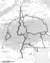
The province’s remaining borders differ in the extent to which they can be reconstructed, and is it only rarely possible to verify what changes may have taken place during the Roman occupation. For instance, the Vallis region was part of Raetia until the middle of the 1st century AD, but thereafter became a separate province under the title of Alpes Poenina. The western border with Upper Germany ran to the west of Lake Constance and probably roughly followed the watershed between the Rhine and Danube. Further south, it continued east of Lake Zurich and included parts of the Ticino, where it marched with the province of Alpes Poeninae (once this was detached as already described). The southern border, with the Italian regiones X and XI, ran south of the main ridge of the Alps from just north of the Lago Maggiore to the Etsch/Adige river (South Tyrol). The eastern border with Noricum mostly followed the Inn, but a strip along the river’s western bank may have belonged to the neighbouring province.
 |
Province of Raetia in the 2nd/3rd centuries AD |
Despite much archaeological effort, there are still large gaps in our knowledge of Raetia’s indigenous population. This is partly due to the nature of the archaeological record, since large parts of the foothills and valleys of the Alps are used as pasture, which results in a relatively low rate of finds recovery. On the other hand, the material culture appears to be very uncharacteristic of the period and defies detailed chronological analysis. Until the 1990s scholars had assumed a lack or at least a low level of settlement, but this view has since changed and widespread settlement is now assumed.
|
 |
 |
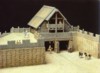
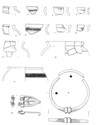
Oppidum of Manching |
Late LaTène Period pit house in Eching |
Late laTène Period burial finds of the südostbayerische
Gruppe |
The alpine areas were not culturally Celtic. In the North and South-Tyrol, the Fritzens-Sanzeno Group is archaeologically attested, a group connected to the Raeti, after whom the latter province was named. It is not clear, however, to what degree the various tribes developed a common identity. This is most likely in a religious context, possibly in connection with a sanctuary at Reitia in Este-Baratella, in Venetia, which seems to have had cross-regional significance. Nevertheless, there is no unequivocal archaeological evidence, especially as a number of groups can be differentiated in the archaeological record south of the ‘Alpenhauptkamm’. The known 1st century BC finds show no break or decline similar to that to the north of the Alps. Instead, traditional dress accessories (mostly from cult sites) point to a continuous settlement history. The Roman conquest and development of Northern Italy, from the 2nd century BC, did not apparently lead to more intensive contacts, and no imports are known, apart from a few cases in the Adige.
 |
Tropaeum Alpium near Monaco |
It is not known how many individual tribes were promoted to self-governing
administrative bodies by the Romans. This can, however, be safely assumed for
the Vindelici with their municipium at Aelium
Augustum- Augsburg; the Brixentes, with their civitas capital Brigantium-Bregenz
and the Estiones with theirs at Cambodunum-Kempten.
Military diplomas and tombstones may refer to other regional administrative
bodies (e.g. Likates and Runikates), although this remains
uncertain, but it is conceivable that certain parts of the province were not
formed into civitates.
|
 |
 |
Brigantium-Bregenz |
Municipium Aelium Augustum-Augsburg |
Cambodunum-Kempten |
 |
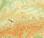
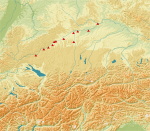
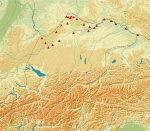
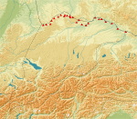
Map of the sites mentioned in the text with indigenous
finds |
For instance, the oppidum at Manching has produced a few finds that
suggest a period of occupation in the first two centuries AD. C14 dates from
Pentling-Poign near Regensburg, point to the continued use of a ‘Viereckschanze’
into the 1st century AD. At Eching near Munich, a farmstead with relatively
small buildings was constructed, c. 20 BC, in vicinity of a Late LaTène settlement
and, as its finds assemblage included military material, it may have been home
to a veteran.
 |
Villa of the early Imperial period |
 |
 |
Finds from the Late LaTéne and early Roman Imperial
periods from the cemetery of Kundl |
Finds from the early Imperial Period from the cemetery
of Innsbruck-Wilten |
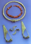
Another early imperial period indigenous population can be recognised in the
so-called ‘Heimstettener Group’, which is identifiable via its grave goods.
The graves and stray finds are concentrated between the rivers Lech and Isar
and are most frequently found in the ‘Münchener Schotterebene’ around the site
that gave the group its name. It is worth noting that these are inhumations
and not the cremations that were customary elsewhere during the Late Celtic
and early Roman Periods. In particular, female burials are known, which are
distinguished by a traditional form of dress with at least three fibulae
and broad, fitted belts. Latticed belt hooks as fasteners, and neck and arm
rings form characteristic parts of this costume, and the latticed belt hooks
are also regularly encountered in other contexts: for example at the cult sites
discussed below. The burials date to between 20 and 60 AD and the people were
once thought to be an immigrant group from the Alps, but they are now seen as
descendants of the Late Iron Age population of the Alpine piedmont.
 |
 |
|
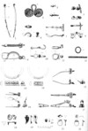
Heimstetten Burial 210, Burial of a woman in traditional
costume |
Heimstetten Burial 210, Jewellery and parts of the
traditional dress |
Location of dress accessories in ‘Heimstettener Group’
burials |
In addition, settlement continuity can also be proven by scientific methods. For instance, pollen diagrams from various locations in the Alpine piedmont show no break between the Celtic and Roman periods, and only some Alpine regions display a decline (followed by an increase) during the first three centuries AD. Likewise, animal bone studies show a continuity of livestock use from the Celtic to the early Roman period.
|
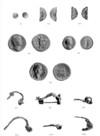 |
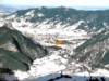
Ritul pyre site in the ‘Forggensee’ near Füssen |
Coins and fibulae from the Late LaTéne and Roman Periods |
 Finds
from a high Alpine sanctuary on the ‘Piller Höhe’ (Tyrol), point to continuous
usage from the Late Bronze Age to the 5th century AD. Burn offerings were abandoned
as a rite here as early as the 4th/3rd centuries BC, and the deposition of goods
(including jewellery, dress accessories, and especially coins) prevailed in the
Late Celtic and Roman periods.
Finds
from a high Alpine sanctuary on the ‘Piller Höhe’ (Tyrol), point to continuous
usage from the Late Bronze Age to the 5th century AD. Burn offerings were abandoned
as a rite here as early as the 4th/3rd centuries BC, and the deposition of goods
(including jewellery, dress accessories, and especially coins) prevailed in the
Late Celtic and Roman periods.Sancturay Pillerhöhe/ Tyrol, Pieces of traditional costume and jewellery from the Iron Age and Roman Periods
On the ‘Döttenbichl’ near Oberammengau, was a sanctuary that remained in use from 100 BC to 50 AD and where numerous Roman weapons were deposited, alongside traditional dress accessories. These included a catapult bolt stamped by the 19th Legion, which perished during the battle of the Teutoburg Forest in 9 AD, and it is assumed that the weapons were picked up by local people after the battle and deposited at the shrine.
 |
 |
|
‘Döttenbichl’(Arrow) in the ‘Ammertal’ near Oberammengau
|
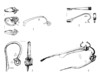
Bolt of a catapult from the sanctuary on the ‘Döttenbichl’
|
Fibulae (c. 100 BC to 50 AD) from the sanctuary on
the ‘Döttenbichl’ |
Resistance and integration In 18/19 BC, the geographer Strabo reported that the Vindelici had been pacified for 33 years, but the above mentioned finds from the ‘Döttenbichl’ attest to military operations during the early period of Roman occupation. This agrees with the written sources, which date the conquest of the province to 15 BC, and report some major battles as well as pointing to the high population of the area. This may be exaggeration for propaganda purposes, however, and there do not appear to have been any native revolts during the early period, as there were in the German and Gallic provinces. That said, from the early 1st century AD, there is increasing evidence for a counter-reaction against rising Romanisation: for example the ‘Heimstetten group’ burials and a reintroduction of ritual pyre sites. In this context older ritual and burial habits were revived which had no longer been practiced during the Late LaTène period and, although the traditional dress was abandoned during the second half of the 1st century AD, most of the cult sites remained in use into Late Antiquity.
 |
 |
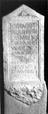
Tombstone of Nunandus, |
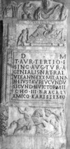
Tombstone of Titus Aurelius Tertius, member of the
imperial guard |
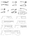
Military Installations
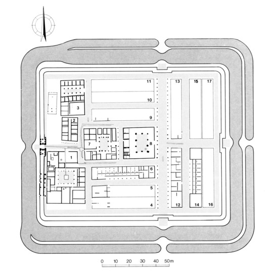
No permanent legionary fortress was established in Raetia until 179 AD when a
base was provided for the newly recruited Legio III Italica at Reginum-Regensburg,
during the course of the Marcomannic Wars. Large parts of the rampart (but few
internal buildings) are known from the 24.5ha site and the north gate, the porta
praetoria, is one of the best preserved Roman monuments in Germany.
 |
 |
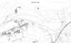
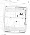
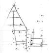
Map of the fortress of Reginum-Regensburg |
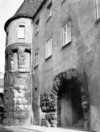
The north gate (Porta Praetoria) of the legionary
fortress of Reginum-Regensburg |
|
|
 |
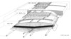
Reconstructed ground plan of the fort at Oberstimm
|
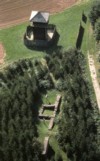
Reconstruction drawing of the ‘Kleinkastell’ at Nersingen |
The Raetian Limes near Rainau-Buch |
|
|
 |
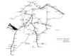
Schematic map of the proven long distance roads in
Raetia |
|
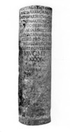
Milestone from Cambodunum-Kempten |
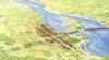
The most important road in Raetia was the via Claudia Augusta, which
ran from Altinum (near Venice), over the Alps to Augusta Vindelicum-Augsburg,
and then on to Submuntorium-Burghöfe on the Danube. A milestone from
Rabland in the Vintschgau, records its construction in 46 AD, in the reign of
the Emperor Claudius, and various sections have been excavated archaeologically.
By the 1st century AD, the Alps had already been crossed by two routes: one
through the Reschen- and Fern passes, and the other over the Brenner Pass. In
Lermoos (Tyrol) and Eschenlohe (Bavaria) it has been possible to investigate
a section of each where tree trunks had been used to consolidate the road because
of a waterlogged subsoil. Dendro-dates from the Lermoos section again date the
road to 46 AD and repairs were made into the 4th century, although the latest
phases omitted the gravelled surface. In the west of the province there was
a further trans-Alpine link, which ran from Como, over the ‘Septimer’ and ‘Julier’
passes, along the ‘Splüngen’, to Curia-Chur in the Alpine-Rhine valley,
and then on to Brigantium-Bregenz on Lake Constance
 |
 |
|
|
Course of the Via Claudia Augusta and other
routes across the Alps |
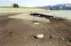
Gravel agger of the Via Claudia Augusta in
the ‘Forggensee’ |
Reconstruction of the building phases of the Via
Claudia Augusta at Lermoos |
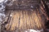
Timber layers from the substructure of the Via
Claudia Augusta near Lermoos |
The east-west routes ran via Augusta Vindelicum-Augsburg and along the Danube whilst, in the western half of the province, they could also pass north of the river. An important route from the provincial capital to the legionary fortress at Argentorate-Strassburg was built in 74 AD, during the conquest of the cross-Rhine areas of Upper Germany. There is also evidence for several link roads, all of which shows that the province had a well-developed road network.
 |
Part of a Roman road near Burladingen with gravelled central section, earth side banks and ditches |
 |
|
|
Plan of a pier of the Roman Danube bridge at Steppberg
|
Reconstruction of the Rhine bridge at Tasgaetium-Eschenz |
Stone bridge with Roman foundations at Mals/ Malles
Venosta |
 |
|
|
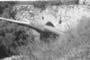
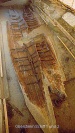
Roman ships from Oberstimm under excavation |
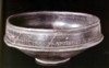
Bowl with dedication to the goddess Erycina following
a nautical tragedy |
Text: Thomas Schmidts
L. Dal Ri/St. di Stefano, Archäologie der Römerzeit in Südtirol – Beiträge und Forschungen (Bozen 2002).
K. Dietz/ W. Czysz, Die Errichtung der Römerherrschaft in Vindelikien, In: Handbuch der bayerischen Geschichte III/2 (München 2001) 46-74.
K. Dietz/Th. Fischer, Die Römer in Regensburg (Regensburg 1996).
W. Drack/R. Fellmann, Die Römer in der Schweiz (Stuttgart 1988).
Ph. Filtzinger/D. Planck /B. Cämmerer (Hrsg.), Die Römer in Baden-Württemberg (Stuttgart3 1986).
Th. Fischer/G. Ulbert, Der Limes in Bayern (Stuttgart 1983).
L. Flutsch / U. Niffeler / F. Rossi (Hrsg.), Die Römerzeit in der Schweiz. Die Schweiz vom Paläolithikum bis zum frühen Mittelalter (SPM) 5 (Basel 2002).
R. Frei-Stolba, Ein neues Zeugnis zum Alpenfeldzug : die Trumplini und Raeti im Sebasteion von Aphrodisias (Karien, Türkei). Jahresbericht des Rätischen Museums Chur 1993, 64–91.
G. Gottlieb, Die regionale Gliederung in der Provinz Rätien. In: Raumordnung im Römischen Reich. Zur regionalen Gliederung in den gallischen Provinzen, in Rätien, Noricum und Pannonien. Schriften der Philosophischen Fakultäten der Universität Augsburg 38 (München 1989) 75-87.
R. Grimmeisen Raetien und Vindelikien in julisch-claudischer Zeit. Die Zentralalpen und das Alpenvorland von der Eroberung bis zur Provinzialisierung (Essen 1997).
H. E. Herzig. Untersuchungen zum römischen Straßennetz in der Schweiz. Der Versuch einer Mikrostraßengeschichte. Bonner Jahrb. 202/203, 2002/2003, 227-236.
E. Keller, Die frühkaiserzeitlichen Körpergräber von Heimstetten bei München und die verwandten Funde aus Südbayern. Münchner Beiträge zur Vor- und Frühgeschichte 37 (München 1984).
C.-M. Hüssen, Endlatènezeitliche Fundstellen im oberbayerischen Donauraum. Bericht der Römisch-Germanischen Kommission 81, 2000, 235-301.
C.-M. Hüssen/W. Irlinger/W. Zanier (Hrsg.), Spätlatènezeit und frühe römische Kaiserzeit zwischen Alpenrand und Donau. Akten des Kolloquiums in Ingolstadt am 11. und 12. Oktober 2001. Kolloquien zur Vor- und Frühgeschichte 8 (Bonn 2004).
H.-J. Kellner, Die Römer in Bayern (München 1971).
W. Krämer, Die Grabfunde von Manching und die latenèzeitlichen Flachgräber in Südbayern. Ausgrabungen in Manching 9 (Stuttgart 1985).
I. R. Metzger/P. Gleischer (Hrsg.), Die Raeter. I Reti (Bozen 1992).
B. Overbeck, Raetien zur Prinzipatszeit. In: Aufstieg und Niedergang der Römischen Welt II,5.2, 1976, 658-689.
D. Planck (Hrsg.), Imperium Romanum. Roms Provinzen an Neckar, Rhein und Donau. Ausstellungskatalog Stuttgart (Stuttgart 2005).
D. Planck/W. Beck, Der Limes in Südwestdeutschland (Stuttgart 1987).
D. Planck/S. von Schnurbein, Der römische Limes in Deutschland (Stuttgart 1992).
M. Prell, Römische Flußbrücken in Bayern. Zum aktuellen Forschungsstand. In: Archéologie des fleuves et des rivières (Paris 2000) 65–69.
M. Rathmann, Untersuchungen zu den Reichsstraßen in den westlichen Provinzen des Imperium Romanum. Beihefte der Bonner Jahrbücher 55 (Mainz 2003).
S. Rieckhoff, Süddeutschland im Spannungsfeld von Kelten, Germanen und Römern. Studien zur Chronologie der Spätlatènezeit im südlichen Mitteleuropa. Trierer Zeitschrift Beiheft 19 (Trier 1995).
Robert Rollinger, Raetiam autem et Vindelicos ac Noricos ... imperio nostro subiunxit provincias". Wann wurde Raetien als römische Provinz eingerichtet? In: Althistorische Studien im Spannungsfeld zwischen Universal- und Wissenschaftsgeschichte. Festschrift für Franz Hampl zum 90. Geburtstag am 8.Dezember 2000 (Stuttgart 2000).
R. Rollinger, Cambodunum versus Augusta Vindelicum. Zur Frage des Statthaltersitzes der Provinz Raetien im 1. Jh. n. Chr. Tyche 19, 2004, 149-155.
A. Schaub, Die förmliche Provinzkonstitution Raetiens unter Tiberius nach dem Zeugnis des Velleius Paterculus. Germania79/2, 2001, 391-400.
F. Schön, Der Beginn der römischen Herrschaft in Rätien (Sigmaringen 1986).
H. Schönberger, Die römischen Truppenlager der frühen und mittleren Kaiserzeit zwischen Nordsee und Inn. Ber. RGK 66, 1985, 321–497.
Sievers, Manching – Die Keltenstadt. Führer zu archäologischen Denkmälern in Bayern. Oberbayern 3 (Stuttgart 2003).
E. Walde (Hrsg.), Via Claudia. Neue Forschungen (Innsbruck 1998).
G. Walser, Die römischen Straßen und Meilensteine in Raetien. Kleine Schriften zur Kenntnis der römischen Besetzungsgeschichte Südwestdeutschlands 29 (Stuttgart 1983).
G. Walser, Studien zur Alpengeschichte in antiker Zeit. Historia Einzelschriften 86 (Stuttgart 1994).
L. Wamser/Ch. Flügel/B. Ziegaus (Hrsg.), In: Die Römer zwischen Alpen und Nordmeer. Schriftenreihe der Archäologischen Staatssammlung 1 (Mainz 2000).
L. Wamser/B. Steidl (Hrsg.), Römische Besiedlung zwischen Oberrhein und Enns. Schriftenreihe der Archäologischen Staatssammlung 3 (Grunbach 2002).
G. Weber (Hrsg.), Cambodunum-Kempten. Erste Hauptstadt der römischen Provinz Raetien? (Mainz 2000).
G. Wieland, Die Spätlatènezeit in Württemberg. Forschungen zur jüngeren Latènekultur
zwischen Schwarzwald und Nördlinger Ries. Forschungen und Berichte zur Vor-
und Frühgeschichte in Baden-Württemberg 63 (Stuttgart 1996).
G. Wieland, Keltische Viereckschanzen. Einem Rätsel auf der Spur (Stuttgart
1999).
H. Wolff, Einige Probleme der Raumordnung im Imperium Romanum, dargestellt an den Provinzen Obergermanien, Raetien und Noricum. Ostbairische Grenzmarken 28, 1986, 152-177.
H. Wolff, Die verspätete Erschließung von Ostraetien und der Nordgebiete von Noricum – ein Forschungsproblem. Ostbairische Grenzmarken 30, 1988, 9-16.
H. Wolff, Die römische Erschließung der Rhein- und Donauprovinzen im Blickwinkel ihrer Zielsetzung. In: Römische Inschriften – Neufunde, Neulesungen und Neuinterpretationen. Festschrift H. Lieb (Basel 1995) 309-340.
W. Zanier, Der Alpenfeldzug 15 v. Chr. und die Eroberung Vindelikiens. Bilanz einer 100jährigen Diskussion der historischen, epigraphischen und archäologischen Quellen. Bayerische Vorgeschichtsblätter 64, 1999, 99-132.
W. Zanier, Der spätlatene - und römerzeitliche Brandopferplatz im Forggensee (Gde. Schwangau) Münchner Beiträge zur Vor- und Frühgeschichte 52 (München 2000).
W. Zanier, Funde der keltischen Viereckschanzen bis in frühe römische Kaiserzeit? Fundberichte aus Baden-Württemberg 28/1, 2005, 207-236.
L. Zemmer-Plank (Hrsg.), Kult der Vorzeit in den Alpen. Opfergaben – Opferplätze
– Opferbrauchtum (Bozen 2002).