Siehe diesen Text auf ![]()
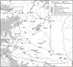
Around the middle of the first century A.D., the region along the Amber Route, with the exception of the southernmost section which led through ‘old Norican’ Celeia, was separated from Noricum and attached to Illyricum, which had a strong legionary presence. The new province of Pannonia was shortly thereafter (at the latest during the reign of Vespasian) created from this region. Under Claudius, the legions which had previously been stationed further inland were moved forward to the Danube, and new encampments at Carnuntum (Bad Deutsch-Altenburg) and probably also already at Vindobona (Vienna) were settled, which protected the crossing of the Amber Route over the Danube into the restless area of the Marcomanni-Quadi. Colonia Claudia Savaria (Szombathely, Hungary), situated half way between Carnuntum and the north-easternmost city of Italy, Emona (Ljubljana, Slovenia), was created as the civil administrative centre and seat of the governor, or at any rate of the tax authorities, and at least as nominal native town for the legionary veterans. In accordance with the importance of the Amber Route region, oppidum Iulium Scarbantia (Sopron), which had already been laid out not far from the Neusiedler Lake during the Augustan period, was elevated to the status of a municipium under one of the Flavian emperors, while the former legionary base of Poetovio (Ptuj, Slovenia) became colonia Ulpia under Trajan (98-117). Apart from that, before the reign of Hadrian, only sites in the already heavily romanised regions of southern Pannonia such as Andautonia (Zagreb), Sirmium (Sremska Mitrovica near Belgrade), Siscia (Sisak) and Neviodunum (Drnovo, Slovenia) received municipal rights.
The northern sector of the course of the Danube, and its entire hinterland, first attained municipal rights during the reign of Hadrian. In Pannonia, the legionary settlements of Carnuntum and Aquincum (Budapest), probably also Vindobona (Vienna), and a series of towns further inland, became municipalities. Apart from a few, uncertain exceptions, with the ‘elevation in rank’ from municipium to colonia at such sites as Carnuntum and Aquincum under Septimius Severus - a circumstance connected to the politics relating to the legions – the municipalisation of Pannonia was completed. The majority of the towns and cities of Pannonia, including its capital, however, lie beyond the borders of present-day Austria and cannot be included within this survey (see the section of the Project, ‘Hungary’).
The Hadrianic city foundations along the Danube were primarily connected, as previously mentioned, with the legions which were stationed here. After the second half of the 1st c. A.D., not only extensive canabae legionis were established in the immediate area of these town foundations, but also a vicus was set up at a distance of ca. 2.2 km (= a roman leuga) from the camp. With the restructuring of the army undertaken during the reign of Hadrian, and with the now customary replenishment of troops originating from the province itself, towns which lay in direct proximity to the legionary camps could not only provide recruits - who had already been prepared for military service through the iuventus-organisations - but could also become the home towns of the veterans. By these means, in the towns along the border, families emerged with long military traditions, a circumstance which can be observed often over four or five generations on tombstones.
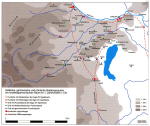
Along the Amber Route, for the foundation of their cities after the mid-first century A.D. the Roman occupiers appear to have almost completely forced out the indigenous population. This is well represented at least at colonia Claudia Savaria (Szombathely). The new population consisted primarily of legionary veterans; in addition, a large number of tradespeople from throughout the empire can be attested through trade association inscriptions. Thus we can identify tradespeople from Emona (Ljubljana) which belonged to Italy, from colonia Augusta Treverorum (Trier, Germany), and from numerous sites from the region of the Euphrates.
In Carnuntum and Vindobana, the situation has been less carefully studied, but it must have been very similar. Even in the years shortly before and after 100 A.D., in the hinterland beyond Carnuntum a certain civitas Boiorum is attested, whose ruler possessed the estate of Bruckneudorf. Certainly, a large number of Germans, brought into the empire under Augustus and Tiberius, were counted amongst the dependents of this Celtic civitas. Above all, family and followers of the Marcomanni kings Marbod and Vannius, banished by their own people, were settled in the area on both sides of the ‘Leithagebirge’. For the entire 1st century A.D., a Germano-Celtic mixed population, settled in small villages and farms, emerges based on the evidence of archaeological finds and inscriptions from the region between Vienna and Bratislava on the Danube, and to the south as far as northern Styria. For the legionary camps and later towns of Vienna and Carnuntum, on the other hand, the Celtic population came to an end already during the Augustan period or shortly thereafter; this circumstance, taken together with other indicators such as early legionary inscriptions, implies an evacuation of the local population and a conscious military occupation of this region and its immediate vicinity already under Emperor Tiberius (14-37). For Carnuntum, a land survey (centuratio) of the surrounding area provides evidence, in particular since the land was distributed amongst Roman veterans.
The course of the city wall erected in the 3rd or 4th c. A.D. at Carnuntum can be securely identified over long stretches. At Vindobona, in sections trenches forming a protective zone around the town are known; these cut through older residences of indeterminate age and function, just as the city wall of Carnuntum had done. At both sites, walled aqueduct pipes, which have not been further researched, are preserved.
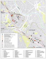
With the exception of the course of the main axis through the town, today the ‘Rennweg’, constituting the decumanus maximus and the connecting route between the legionary camps of Vindobana and Carnuntum, and a few side streets (cardines) branching off from it at right angles, next to nothing is known regarding the street system of the municipium Vindobonense.
Of Vindobona’s public buildings, only a bath complex has been partially excavated; nothing concrete is known regarding temples and sanctuaries at the site. Only the location of the Forum and of a connected area sacra in the eastern region of the municipium, next to the ‘Ziakplatz’, can be assumed on the basis of finds of fragments of statues. This almost peripheral location at the east end of the town can be explained by the fact that the western region of the town was probably heavily built up with the vicus that existed here since the late 1st c. A.D.
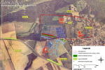
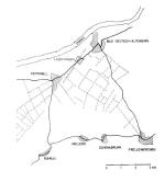
The city plan of the Hadrianic Municipium and Severan Colonia Carnuntum reveals – at least for the area enclosed within the city walls – an oval shape of hybrid rectangular and elliptical form (dimensions 1,150 m x 525 m; proportions ca. 2:1), with decumani running in part directly east-west and in part curving, and cardines running slightly diagonally and in part bending. One road follows a totally diagonal course from the south-east corner of the Forum in a south-west direction. The Forum itself, only identified on the basis of ground survey, lies approximately in the centre of the town; the decumanus maximus runs past its north side where the Basilica is located, while on the side of the street opposite the Forum is a place identified as a Macellum, behind which is a large bathing complex.
The city blocks present greatly differing dimensions, ranging from 37.5 x 75 m. (primarily in the town centre) up to 100 x 100 m. The settlement, which originated as a vicus in the mid-1st c. A.D., took its orientation from pre-existing highways – in a similar fashion to the neighbouring canabae legionis and the substantially later settlement near the Norican legionary camp of Lauriacum – namely, the road bypassing the camp, and the routes which led away from the settlement via the town gates. Therefore, by the time of the formal town foundation, the plan was to a great extent already in place. The amphitheater was located at the southernmost border of the town, on one of the major highways. Public sanctuaries within the town have not yet been fully researched, although a podium temple did lie at the south side of the Forum. The sanctuaries located in the canabae legionis and on top of the nearby ‘Pfaffenberg’ (see the chapter ‘Carnuntum’) would certainly have been frequented by the inhabitants of the town.
Peter Scherrer
J. Fitz, Die Verwaltung Pannoniens in der Römerzeit , 4 Bände (1993–1995).
V. Gassner – S. Jilek – S. Ladstätter, Am Rande des Reiches. Die Römer in Österreich, Österreichische Geschichte 15 v. Chr. – 378 n. Chr. (2002).
F. Humer (Hrsg.), Legionsadler und Druidenstab. Vom Legionslager zur Donaumetropole, Sonderausstellung aus Anlass des Jubiläums "2000 Jahre Carnuntum", 2 Bände (2006).
M. Šašel Kos, The End of the Norican Kingdom and the Formation of the Provinces of Noricum and Pannonia, in: B. Djuric – I. Lazar (Hrsg.), Akten des IV. Internationalen Kolloquiums über Probleme des provinzialrömischen Kunstschaffens. Akti IV mednarodnega kolokvija o problemih rimske provincialne umetnosti, Celje 1995, Situla 36 (1997) 21–42.
M. Šašel Kos – P. Scherrer (Hrsg.), The Autonomous Towns in Noricum and Pannonia – Die autonomen Städte in Noricum und Pannonien: Pannonia I und II, Situla 41+42 (2003–2004).
For additional literature, see also the chapters ‘Carnuntum’ and ‘Vindobona’.