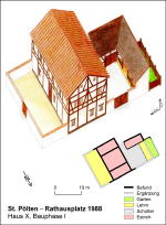
Siehe diesen Text auf ![]()
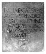
In the period 10/9 B.C., that is, only a few years after the occupation of Noricum by Rome (16/15 B.C.), four honorific inscriptions, set up contemporaneously in the city on the Magdalensberg by the Norican tribes for members of the Imperial house (Augustus, his wife Livia, his daughter Julia and her daughter also named Julia), make reference to eight Norican tribes. Named were: the Norici, Ambilini, Ambidravi, Uperaci, Saevates, Laianci, Ambisontes, and (H)elveti, six of which were also listed in the Geography of Claudius Ptolemaios, who also mentioned the Alaunoi. Inscriptions of the early and mid-Imperial period also record the proper name ‘Ambisavus’, derived from a tribal name, in south-east Noricum and an ‘Ambidravus’ in the upper Drau valley. Dedications in the Chiemsee region refer to a ‘sacrum Alounarum’, that is, the tribal sanctuary of the Alauni/Alounae. Furthermore, the Laianci (cf. Lienz in east Tyrol) and the Saevates (Pustertal, cf. Sebatum, Sabiona/Säben) erected around the mid-1st c. A.D. an honorific inscription in Iulium Carnicum (Zuglio), the home town of C. Baebius Atticus, probably the first procurator Augusti in Norico.
Up until the organisation of the province of Noricum under Emperor Claudius (41-54 A.D.) the Norican civitates played an active role, at least in cultic affairs and in the honouring of prominent persons. During the 2nd and 3rd centuries, the ceremonies in the sanctuary of the Alounae were performed by the duumviri iure dicundo of Iuvavum (Salzburg), in a similar fashion to those carried out by the duumviri of Aquincum (Budapest) in the neighbouring province of Upper Pannonia in the name of the civitas Eraviscorum.
The geographical distribution of the tribes according to the text of Ptolemaios is certainly incorrect in part; in addition, certain civitas are not mentioned or were misunderstood by copyists. Based on the find-spots of inscriptions which record proper names derived from tribal names, combined with modern names of sites which reflect ancient site names, and additional factors, a rough idea of the geographical extent of the tribes can be arrived at. For example, one may tentatively infer that, after Claudius, two civitates each were assigned to a newly-founded municipium: the Norici in central Carinthia and the Ambilini in the Gail valley belonged to Virunum, so that it had in its territory the two important Alpine crossings towards Iulium Carnicum, the roads to the Kanal valley and the Plöcken pass. The Laianci (east Tyrol) and the Saevates (Pustertal) were assigned to Aguntum, the Ambinsontes and the Alounae to the city of Iuvavum, while the Uperaci and the ‘Ambisavi’ could have belonged to Celeia. From this it follows that the Elveti, who can not be more precisely localized, together with the Ambidravi most likely belonged to Teurnia. Hereby all known civitates, and all cities with foundation dates in the period of the establishment of the province, are accounted for, and the oft-regretted silence of the ancient sources with regard to additional tribes is also no cause for surprise. Doubtless no others existed.
Under Emperor Claudius the actual situation of occupation of Noricum was ended, and, according to the testimony of Pliny (nat. hist. III 146), immediately five municipia were created in the new province which was now administered by an equestrian procurator Augusti in Norico and a procurator Augusti provinciae (or regni) Norici and which was directly under the command of the emperor. These five municipia were Aguntum (Dölsach near Lienz in east Tyrol), Teurnia (St. Peter im Holz, near Spittal an der Drau), Virunum (Zollfeld near Maria Saal), and Celeia (Celje, in northern Slovenia) in the south, all separated from Italy by a mountain pass and a day’s journey, as well as Iuvavum (Salzburg) in the north-east; under Vespasian, a sixth city was added, namely Flavia Solva (Wagna near Leibnitz in the southern region of east Styria).
The northern section of the course of the Danube, and the entire land beyond it, first underwent ‘municipalisation’ under Hadrian. In Noricum, the sites of Ovilavis (Wels) and Cetium (St. Pölten) became municipia. Leaving aside the uncertain exception of Lauriacum (Lorch-Enns), and the elevation in rank of Ovivalis from municipium to colonia during the reign of Caracalla (211-217), a circumstance connected to the politics regarding the legions, the ‘municipalisation’ of Noricum was thereby completed.
From the time of Claudius up until Vespasian, the process of urbanisation only extended as far as the Drau valley (Aguntum, Teurnia, Virunum), the Save valley and the Amber Route (Celeia), the lower Mur (Flavia Solva), and, as an apparent exception, with Iuvavum the Salzach valley in the northern Alpine foreland, that is, the core region of the regnum Noricum. The northern and eastern regions (the Alpine foreland up to the Danube, and Styria), which first fell to Noricum after the destruction of the Boii, first needed to be systematically settled and structurally made accessible. Nearly all of the settlements which were elevated to cities up till 79 A.D. reveal consistent features: they are located on large rivers or at river crossings, that is, junctions of prehistoric traffic routes, they possess an Augustan or slightly later core settlement (in so far as appreciable archaeological research has been able to determine), and in more or less close proximity an important settlement, or often numerous settlements, dating to the late Latène period and having the function of a central site can be identified. This is particularly the case for Iuvavum, which indeed was set up at a crossing of the Salzach along an important east-west route, which intersected here with a north-south crossing of the Alps and the entrance to the lower course of the river Inn. Nonetheless, larger settlements which immediately preceded these at the same site, as was the case for example in tres Galliae, cannot be identified at any of the Roman cities in Noricum.
The similarities mentioned above also apply to a series of additional settlements, which however never attained more than the status of a forum or vicus. Most of these sites are located on the traffic routes created by rivers, at the junctions of such routes, or in front of passes, usually at a distance of a day’s journey from each other or to the nearest city. In their topographical situations and favourable locations with regard to communication, these sites possess similar characteristics to the Claudian and Flavian cities, but are, however, clearly later in their sequence from south to north, with exceptions. Thus for example the vicus of Kalsdorf near Graz, to the north of Flavia Solva, began apparently in the Tiberian period. The closest settlement to the north, near what is today Gleisdorf, seems to have first been set up around the middle of the 1st c.; the north-south running east Norican route leading to Vindobona and Carnuntum in Pannonia Superior ran past here, and from this route, a road branched off to Savaria. In the inland regions, relatively undeveloped until then, new settlements continued to grow up until approximately the mid-2nd c. A.D. Near the Danube, in the lands behind the militarily dominated border, a few of such sites, with locations favourable for communication, received municipal rights under Hadrian. With some delays, the important factors for the development of a settlement into a city thus remained the same over a period of three-quarters of a century.
Nevertheless, for the younger cities of Ovilavis and Cetium, and lastly Lauriacum in the Danube region, an additional factor played a role. With the restructuring of the army undertaken during the reign of Hadrian, and with the now customary replenishment of troops originating from the province itself, towns which lay in direct proximity to the legionary camps could not only provide recruits - who had already been prepared for military service through the iuventus-organisations - but could also become the home towns of the veterans. By these means, in the towns along the border, families emerged with long military traditions, a circumstance which can be observed often over four or five generations on tombstones.
For a few of the early city settlements, above all for the city-like settlement on the Magdalensberg in central Carinthia, but also for Teurnia and Solva, an additional factor related to their specific location came into play. The Roman trade settlement on the Magdalensberg located in regnum Noricum, then still viewed as foreign territory, seems to have developed under the protection of a regionally important sanctuary of the god Belinus (?); perhaps here already for a long time a market had periodically taken place. Indicators for a similar development at a Latène-period sanctuary are also present at Teurnia, since in the central area of the city a late Latène-period deposit of ten deliberately deformed shield bosses has been found. On the Frauenberg, above the later city of Solva, in addition to traces of settlements from the Latène and early Imperial periods, a Celtic sanctuary with surrounding trenches has been discovered; this was in use approximately until the Claudian period, and in the Flavian period it was replaced by Roman temple buildings.
The original purpose of the settlement erected on the Magdalensberg in central Carinthia after the mid-1st c. B.C., that is, within the period of the independent regnum Noricum, is still vehemently discussed. Earlier, one assumed the existence of a Norican princely seat, perhaps even the site of a mint, at the top of the mountain, in the shadow of which the Roman traders made their settlement; now, however, the settlement seems more and more to have been constituted almost exclusively of Italo-Roman tradespeople, who owed their development here to the increasing demand for weapons and other products made from the renowned ferrum Noricum (Norican iron) after the beginning of Caesar’s Gallic War. It has recently been proposed that the massive stone constructions erected on the mountain peak in the (early?) Augustan period need not necessarily represent foundations of a fortress, but that instead they might have served as a sanctuary laid out in terraced form according to Mediterranean prototypes and furnished with large colonnades.
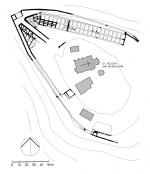
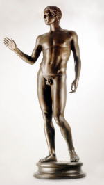
In any case, the existence of a temple on the peak, erected according to southern (Italo-Mediterranean) construction principles, is undisputed, among other things due to the discovery of numerous clay antefixes. The life-size bronze statue of a naked youth – a chance find from 1502 – now securely dated to the Augustan period but its interpretation still hotly disputed, needs to be brought into the argument. The statue, known as the ‘Youth from Helenenberg’ (as the Magdalensberg was formerly called), can be identified on the basis of a donor’s inscription on its right thigh as a dedication on the part of two procurators from trading families from Aquileia, and originates from a Mediterranean, probably Italian workshop. Along with the statue, a bronze object in the form of a shield (now unfortunately lost) was also found; this had a similar dedicatory inscription referring to three donors, amongst whom once again an Aquileian, L(ucius) Barbius L(ucii) f(ilius) Philoterus was recorded.
Finally, a foundation myth handed down in Byzantine script, its meaning however only recently recognised, may be mentioned in connection with the manner in which the inhabitants of Old-Virunum – as the settlement may be termed – saw themselves. Here, Virunum is explicitly identified as a mountain site, laid out and inhabited by Italians in Noricum. Its name may be traced back to the heroic deeds of a single individual (vir unus), who was credited with freeing the region from a gigantic wild boar. The myth is a fine example, and perhaps even the most recent, of a type of foundation myth connected with a boar hunt, and common in particular throughout Asia Minor, for example at Prusa in Bythinia, Aphrodisias in Caria, and – above all – at Ephesos. Trading contacts between the settlement on the Magdalensberg and the province of Asia (western Turkey), in particular its main port of Ephesos, can be proven already in the Augustan period via imports through Aquileia. Furthermore, a strong group of inhabitants originating from the orient can be adduced on the basis of preserved names, amongst them for example A(ulus) Poblicius D(ecimi) l(ibertus) Antioc(us), one of the donors of the bronze statue of the youth.
Leaving aside the construction of the city by Italians, a scenario explicitly portrayed in legend, the incorrect etymological explanation for the city name also reveals typically Roman-antiquarian tendencies. The fact is that, seen from the viewpoint of religious historians and linguists, Virunum is much more likely to be connected with an ‘ancestor’, and therefore more likely with a hero of regional significance (Belinus, a god associated with healing and water springs?), who possessed a sanctuary on the Magdalensberg.
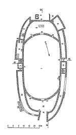
The city underwent four main phases of construction. The oldest finds date back to the mid-1st c. B.C., followed by a systematic development in the early- to mid-Augustan period, with the site on the mountain peak and the district around the Forum. The so-called ‘Representation building’, which above all served as a bath building, lay in the north-west of the Forum. On the north side of the Forum, in the Tiberian period a large prostyle podium temple was constructed on top of a place where iron had earlier been smelted. Between the temple and the baths lay a large court (hypaethral basilica?) with tribunal, possibly the office of the Roman military governor of occupied regnum Noricum. In the south, opposite the temple, was located a hermetically sealed off building complex where gold was melted, an imperial possession. To this complex also belonged a representative building (the so-called Large Villa) with bathing facilities, large bakery, and guest rooms at the south-west of the Forum; the imperial administrators and guards associated with the transportation of gold and rock-crystal may have resided here. On a slope opposite, a building complex identified as the principia or commander’s headquarters was located. In the Augustan period, the east side of the Forum was taken up by a basilical building, which on the basis of numerous wall inscriptions functioned as a market building, but which by the time of the described development of the city under Tiberius no longer existed.
Around the mid-1st c. A.D., just while the Forum temple was being furnished with a ring of columns and a surrounding colonnade, the settlement came to an end, suddenly and permanently, with the construction of the Norican governor’s seat in Virunum, a new foundation in the Glan valley. Independently of whether or not the Magdalensberg-city already had the name ‘Virunum’ or not, she is certainly to be judged as a predecessor of the new ‘capital city’, perhaps together with other settlements in the surrounding region.
According to unanimous scholarly opinion, the relocation of the city was directly related to the substantially more convenient communication routes, and the shortening and simplification of transportation routes. Similar trading posts to that on the Magdalensberg, which however never attained its size or importance, were developed in the Augustan period or even earlier in Nauportus (present day Slovenia) for the trade along the Amber Route, and on the Gurina in the Gail valley. The Gurina constituted an important emporium for wares from and to upper Italy already in the mid-first millenium. A sanctuary here is well-attested by numerous inscriptions in the Venetian language, statues of divinities and dedications from the Iron Age and Roman periods, as well as by a temple of gallo-roman type with central cella and surrounding porticoes; the publication of the excavations which resumed here in 2004 is forthcoming. Therefore, at this time nothing more specific can be stated regarding the precise significance of this site during the transitional period from Celtic to Roman Noricum.
The entire long-distance routes from Noricum to the south led via Emona in the north-east and Iulium Carnicum in northern Italy directly to the major port of Aquileia (near present-day Trieste), where a branch of the Amber Route which led through Dalmatia to Greece also terminated. Actually, the early Norican cities could be viewed as indirect foundations of Aquileia, whose leading trading families, for example the Barbii, also constituted the main contingent of the procuratores active in the provincial trading settlements elevated to the status of municipii.
After the yield from the Norican gold-producing hills in the Hohe Tauern, which demonstrably flowed into the imperial coffers already under Gaius Caesar (known as Caligula, 37-41), the second most important export article from the region – in addition to textile production from sheeps’ wool – remained iron production and its working. The mines (ferrariae Noricae) which were leased from the state apparently remained under the control of the leading traders of Aquileia up until the later 2nd c. A.D. A leading role in the foundation of trading stations was played not only by mining activities in the southern and central Alpine districts to the north of Virunum (above all in Feldkirchen, and in the Görtschitz and Glan valleys) and in the Carinthian lead mines, but also by the production, smelting and commerce of iron ore from beyond the Alps. The town of oppidum Iulium Scarbantia (Sopron), founded under Tiberius (14-37) in what was probably still a Norican region, lies directly in the centre of the iron industry region of Burgenland – western Hungary. Even though archaeological evidence has not yet come to light, the location of the vicus Lauriacum, already by ca. mid-1st c. A.D., at the mouth of the Enns river where it enters the Donau can most probably be explained as a transportation port for iron(ore) from the surrounding Enns-Steyr river system, still known today as ‘Eisenwurzen’. Furthermore, the fact that the Romans took up the Hallstatt settlement again is equally more likely to be related to the smelting of iron than to salt mining, which at that time had been abandoned. Additionally, coming from the north, the so-called inner-Norican route ran at first along the rivers Enns and Steyr, then over the Pyhrnpass (forking off towards Iuvavum in the upper Enns valley) and over Liezen into the Palten valley and onwards into the Mur valley, whence Flavia Solvia could easily be reached, or even Virunum via a few small passes. Scarbantia and Lauriacum in particular attract attention as early exceptions, not only due to their early date but also to their location within the context of Roman settlement in the Danube region.
The administrative reforms of the province of Noricum under Marcus Aurelius (161-180) in the course of the Marcomanni wars signified at the same time an end to old dependencies and alliances. The stationing of the reorganised legio II Italica in Lauriacum, and the subsequent relocation of the governorship to the Danube region, reversed the inner Norican economic cycle. While up until that point almost the entire trade in the region had been conducted through northern Italy, above all via Aquileia, now, with the doubling of the Norican army and the subsequent increase in supply requirements, thousands of soldiers, potential customers, were stationed in the barracks of the Danube region, from the river Inn as far as the Waldviertel. Perhaps already due to the emergency situation caused by the defensive wars against the German hordes, although probably far more likely due to far-reaching strategic economic measures, around 170 A.D. the (south) Norican iron mining and production was placed under direct state control. Aquileia lost an important source of income, and the Norican tradesmen were able to disentangle themselves from their relationships to their earlier ‘regular customers’ in the northern Italian cities, replacing them with trade now oriented primarily to the north and based on the army stationed there. The flowering of the province of Noricum under the Severan emperors (193-235) is illustrated by an in part luxurious rebuilding of the destroyed cities after the devastation carried out by the Marcomanni. The financial background for this heyday was based on the liberation from dependency on Aquileia and other northern Italian cities, and resulted in a new sense of self-confidence on the part of the leading civic classes, who in these decades increasingly developed their own, typically provincial Roman identity. Their conspicuous characteristic is the nostalgic recourse to Celtic-Norican traditionalism.
In all of the Norican cities, excavations carried out in recent decades have brought to light residential buildings – more or less distributed throughout the entire city region – which also fulfilled commercial functions. In particular in the 1st/2nd centuries A.D., agricultural structures which more closely resemble farm buildings than city houses were not uncommon on the borders of the towns (see below in the section on ‘Residential Buildings’).
Particularly recognisable is the working of various metals and alloys, in particular iron, bronze and lead; in the towns that have been well-studied, the entire spectrum of metal products, from building- and agricultural equipment up to jewellery and decorative elements for clothing, is represented. Pottery production is identifiable practically everywhere, although only infrequently were higher quality products, such as Terra Sigillata, attempted, in addition to vessels for daily use and better-quality tableware. To date, individual fragments of the moulds for such Terra Sigillata bowls have only been found in Iuvavum and Cetium. The major share of the wares and provisions produced in the towns was intended for local and regional markets, and for the requirements of the troops stationed along the Danube. Textile production is harder to identify, and is recognised primarily by inscribed lead tags; it certainly, however, played an important role for the Norican export business. Loden fabric made from sheeps’ wool fulling was made into a distinct type of cloak with hood (paenulae), similar to a rain cape or poncho; after the rule of the Severans at the end of the 2nd c., this garment also formed a component of military costume.
Storehouses or sites where goods were stocked have not yet been identified in Noricum, although in Ovilavis, a building which has only partially been excavated has been tentatively identified as fulfilling this function.
In contrast to the traditional view in the scholarship, which held that in the early municipia it was above all the indigenous, originally Celtic nobility, invested with the civitas Romana bestowed ad personam, who had established themselves as the leading classes, and the plebs oppidana only had at their disposal the lower-status ius Latii, nowadays a completely different picture is emerging. An analysis of the names of civic public officials and council members (duumviri iure dicundo, aediles, quaestores, decuriones) reveals that for at least 70 % of these honestiores, a relationship to immigrants from the Italian and Mediterranean regions can be established; this is particularly true for families originating in Aquileia, Iulium Carnicum or Tergeste. Moreover, in these classes, gentile names based on Celtic names or imperial naming formulas (Iulii, Claudii, Flavii) are relatively rare, independent of whether or not citizenship was bestowed based on military duty in auxiliary units, or on other grounds. It is first in the Hadrianic cities of Ovilavis and Cetium in the region beyond the border that ‘Ulpii’ and ‘Aelii’, as well as aristocratic landholders of Celtic descent, become prominent.
A similar situation exists for the overall diffusion of ‘Italian’ gentile names on funerary and dedicatory inscriptions (compare the above-mentioned Barbii), which appear increasingly in the urban central regions and along the main communication routes, whereas Celtic naming forms are more typical for single farmsteads or sporadic settlements in the countryside. This indicates that the Norican aristocracy, even families in which princely names known from coins such as Adnamat or Tinco were handed down over generations, maintained their traditional lifestyles on agricultural estates, and only gradually were able to attain citizenship via service in the auxiliary units of the army, above all in the cavalry units.
 |
 |
 |
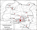
Distribution
of the Sabinii in Noricum.
|
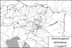
Distribution of the princely name Iantumarus
|
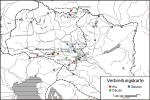
Distribution of the typical norical-celtic names Aiu/Aiuccio und Causo/Couso
|
On these grounds it is understandable why in Noricum, where we have a total of ten known tribal names from differing sources at our disposal, not one single city adopted an ethnic reference in its official titulature. The designation of a communal entity, of a city state, indeed needs to be viewed as the primary and clearest signifier of identity of a settled community. If, therefore, a local colony calls itself colonia Augusta Treverorum (Trier) or Augusta Vindelicum (Augsburg), in spite of all of the Roman immigrants, the identity of the old political grouping (the civitas) has been preserved or knowingly put on display. Although in Noricum in the Imperial period we indeed hear sporadically of an Ambidrabus, Ambisavus, or Uperacus, that is, people who acknowledged their descent from indigenous tribes; and although in the mid-2nd and early 3rd c. A.D. a sacrum Alounarum is attested, that is, a tribal sanctuary of the Alaunoi, as Ptolemaios calls them (2.13.2), in Noricum such designations are absolutely unheard of in the names of the cities. Instead, for the city designations, pre-Roman toponyms, generally indicative of site (Aguntum), landscape (Cetium, from mons Cetius = Wienerwald), and rivers (Iuvavum from Ivarus = Salzach?; for Solva, cf. the present-day river Sulm), or names of sanctuaries (Virunum?), were simply combined with the nomen gentile of the emperor during whose reign the town received civic rights. The leading classes in these cities did not feel themselves to be Norici, Ambisontes or Laianci. These tribal organisations perhaps continued to exist within the territoria, fines or agri of the city for a certain time as particular organisations (civitates or pagi), yet their activities were limited – as the preserved inscriptions show – almost entirely to ‘religious’ assemblies, above all in the scope of the Imperial cult, and, interestingly, in the honouring of prominent persons such as senators and provincial governors who had served the cities as benefactors and patrons.
The fact that the earliest Roman immigrants - whether they came seeking gold or metal ores, or as tradesmen or craftsmen – were generally young, mobile men, meant that, if they settled permanently, they frequently founded families via marriage with the daughters of the indigenous, landholding upper classes. This circumstance held advantages for both sides: on the one hand, the men brought the civitas Romana and its accompanying legal rights, and possibly even political influence, while on the other hand the women brought land and animals as their dowry. In these mixed families, the local religious customs were handed down just as the Norican-Pannonian female costume was, including its particular jewellery and fibula forms, until well into 3rd century A.D.; this led to an expression of civic culture tinged with local colour, a circumstance which is archaeologically attested above all in the various civic cults and via the representation of women on funerary monuments. Even in the leading families, or precisely due to them, Celtic names – in particular for pseudo-cognomina for women – also remained in fashion or became fashionable again in the late 2nd and 3rd centuries. Thus, for example, the names ‘Belatumara’ in Iuvavum, ‘Eliomara’ in Virunum and ‘Litugena’ and ‘Mussa’ in Solva are attested for the wives of council leaders and municipal officials.
Based on the foregoing statements concerning the origin of the Norican-Pannonian city inhabitants – and taking into account the fact that a local, pre-Roman tradition of stone construction did not exist – it is in no way surprising to note that local characteristics are apparent neither in the planning and structure of these towns nor in the form of their public and private buildings; everything is derived from imperial Roman, above all from northern Italian, prototypes.
Although in many towns archaeological research had already begun in the 19th century, for the majority of sites the methods and possibilities offered by the modern city archaeology of the previous 20 years have first led to concrete, if still very provisional, results. In many locations, due to the density of recent development, only small-scale excavations, or rescue excavations necessitated by new construction and taking place within a very short time-frame, have been able to be carried out. Precisely in Virunum and Solva, where to a great extent the ancient civic structures lie in open areas of land, only very limited modern excavations have taken place.
The existence of city walls has until now only been established in the province of Noricum at Aguntum, Celeia and Ovilavis. At Celeia, the west gate of the city has recently been excavated. The city wall of Aguntum represents a peculiarity, as here the walls do not enclose the city, but instead extend as a straight stretch of wall with numerous towers and a main city gate, protected by towers, at its western border. In the scholarship this circumstance has been explained, less than convincingly, as relating to the specific topographical situation of a narrow river valley in the Alpine region, in that the wall basically functioned as a barrier against enemies from east and west, or held back flood waters, or simply only had a representative function. Currently, a date in the 3rd century is favoured. For all of the cities mentioned, the city walls were erected at a relatively late date, rather in the 4th than in the 3rd century; they also cut through older residential buildings and left certain city districts, which had earlier been inhabited, outside their circuit. At Cetium, indications are present for a defensive system with trenches, whose date and function however have not yet been precisely determined.
 |
 |
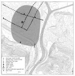
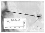
Aguntum:
Aguntum: excavated area
|
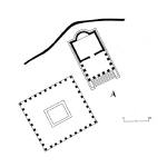
Ovilavis:
location of the Roman city
wall
|
At the moment there is no evidence for aqueducts with large volume capacity, but at Virunum, Iuvavum and Ovilavis, water was piped into the towns from springs in the surrounding regions.
To date, amphitheatres in the Norican cities have only been excavated in Virunum and Solva, while a further one is known from the unnamed vicus at Gleisdorf in Styria. In all cases, the amphitheatres lay at the borders of the towns, somewhat removed from the regular construction of the insulae.
In spite of its form which resembles a circus, the amphitheatre in Virunum, described as such many times in inscriptions, was erected at the earliest after 131 (date of the felling of the trees), and renovated under Emperor Commodus. A building inscription, which is probably datable to 183, mentions plastered walls, main entrance, and gateways. During the co-reign of Septimius Severus and his sons (building inscription from the period 198-211), the amphitheatre was further embellished with wall paintings (picturae). The exterior dimensions totalled 108 x 46.5 m., while the arena covered an area of ca. 99 x 37 m. The amphitheatre at Solva was ca. 105 m long and 50 m. wide. The socle walls of mortared rubble probably supported wooden tribunes. The arena itself possessed dimensions of 80 x 35 m.
Thus both of these amphitheatres were relatively similar in size, and offered seating for approximately 3,000 spectators. It is likely that they were planned at the inception of the towns, as older buildings located beneath them have not been discovered. For the amphitheatre at Virunum, a late Hadrianic building date is certain based on dendrochronology (after 131 A.D.), and it is assumed that the amphitheatre at Solva was probably constructed at roughly the same time.
In addition, Virunum possessed the only theatre building with a stage, traditionally dated to the Hadrianic-early Antonine period, in Noricum; this had a semi-circular area for spectators, with a radius of 35 m. The structure was completed at the top by a covered walkway with a roof supported by piers. The stage was 32.5 wide and 5.8 deep. Behind it lay a 4.5 m. wide colonnade with seven chambers and a two-storey elaborate façade decorated with niches and facing the city.
 |
 |
 |
Amphitheatre
at Solva, ground plan
|
Amphitheatre at Virunum, ground plan
|
Theatre at VirunumVirunum: ground plan
|
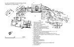
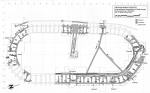
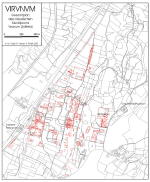
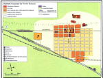
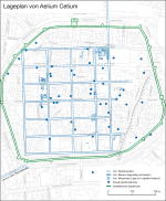
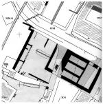
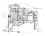
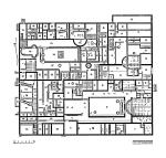
The city plan of Aguntum, which may have already developed during the Augustan period with the earliest settlement location, and which is only known in sections, took a forked intersection as the basis of its construction scheme. Probably a number of the star-shaped routes of the main routes in the Drau valley were connected via cross streets. The city plan of Virunum, on the Zollfeld near Maria Saal, reveals itself even today in the form of streets, field pathways, and borders between land tracts, since after the end of the Roman period the city region was not built over with larger settlement structures. Almost a kilometre to the north of the densely developed city core, which had a regular street grid and an overall area of ca. 1 km², the long distance road which travelled through it divides, with one branch leading off tangentially to the west past the city. The other branch, as the decumanus maximus of the inner urban surveying system, leads axially to the Capitoline temple located at the Forum, and divides the insulae to the north and south of the Forum area into two narrow strips. The cardo maximus runs in an east-west direction between the Capitoline region and the Forum. The residential districts mostly lie between the Forum and the tangential street, the majority of the building blocks of roughly square form having side lengths of about 66-72 m. or almost 100 m., while some of the insulae were significantly smaller or laid out as rectangles. To the east of the Forum, only one more row of insulae is located, and then the land slopes up into the hills. At the edges of the slope, the theatre and amphitheatre are located, while further up can be found a building complex which has been interpreted as the residence of the governor but not further investigated; finally, recently a military camp has been identified on the basis of aerial photography and walking survey.
 |
 |
Virunum,
city plan with overview of
the known structures
|
Virunum:
hypothetical reconstruction
of the city grid
|
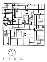
The only municipium in Noricum which was founded in the Flavian period, more specifically during the reign of Emperor Vespasian (69-79 A.D.), Solva, lies on the western bank of the river Mur. According to the current scholarly thinking, the city possessed a densely developed area of almost 600 x 400 m., but may well originally have had a roughly square ground plan; the missing districts in the east, where the Forum and other public buildings were located, must have been destroyed in late antiquity by the Mur river and, in areas, completely washed away. The regularly laid out city blocks, enclosed by walls, were separated by broad streets with a width of from 12 to 20 m. The two central rows of insulae, located on both sides of the long-distance road which entered the city from the north and served as the city’s cardo maximus, were in general ca. 70 m. in length (east-west) and ca. 60 m. in width; to the west followed one city block row of ca. 45 m. in width, and then the scheme of development from here to the edge of the town was relatively uneven, with two additional rows of insulae. Seen from an east-west direction, the two rows in the center, between which the decumanus maximus must have run, display a maximum width of only 40 m., in contrast to the above-described widths of 60 m. Based on parallels with Virunum and other cities, the Forum should have been laid out at the eastern end of these rows. In spite of the fact that parts of the later city appear to have been only temporarily settled, in the Augustan period the city plan represents the result of a uniform plan, one which did not take into account pre-existing pre-urban structures. Securely identified public buildings at Solva include an amphitheatre in the south-west of the city, and a bathing complex.
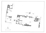
Cetium was laid out in the second quarter of the 2nd c. as a planned city (maximum extension ca. 500 x 500 m.), and probably did not have any significant forerunners. It possessed a grid street system oriented almost exactly to the cardinal points, with insulae with regular north-south dimensions of ca. 66 m., and between 55 and more than 90 m. in width. All of the known streets were 6 m. wide on average, with a cambered gravel surface with side trenches which were generally uncovered; only one cardo was fitted with a walled drain built at a later date and running along its west side. Compared to the rest of the city plan, the orientation of the built structures in the easternmost area of the town appears to have altered direction, seemingly oriented to the edge of a tract of land on the border of the flood plain of the Traisen or to a street which hypothetically ran past here. There is evidence for the location of the Forum, but due to the dense later development, it is not possible to study it in any more detail.
The narrowness of the partially level tract of land available for building, between steeply looming mountains and the sinuous course of the Salzach river, as well as the existence of an Augustan vicus on the route leading to the ford over the river, probably also led to the development of a partially crooked street system at Iuvavum; due to dense urban development in the old city of Salzburg, however, only rudimentary remains have been able to be uncovered.
Even more complicated is the situation at Celeia (Celje) and Ovilavis (Wels), which according to indications so far, seem to have possessed rectangular street systems, but which even so needed to take into account pre-Roman buildings and the course of the river. Recently, the location of the Forum at Celeia has been identified through excavations: it had an overall area of 106.6 x 53.3 m. (180 x 360 Roman feet), with 13.3 m. wide colonnades on its long sides. The discovery of marble reliefs indicates that these colonnades displayed architectural decoration of extremely high quality.
Leaving aside the location of the Forum on the Holzerberg, at Teurnia there is hardly any evidence for the inner city division of land for settlement. Only in the plain at the western perimeter of the city, where a residential quarter of the 1st-3rd centuries has been excavated, a few traces of gravelled roads, irregularly laid out in relation to each other, have been identified.
In conclusion, with regard to the planned form of the Roman cities in Noricum it can be stated that their overall area generally encompassed between 25 ha. and 1 km², indicating a population of ca. 2,500 to 10,000. As far as can be proven, in general, city blocks of from 1,500 up to almost 10,000 m² in one and the same city were created via an irregular checker-board system of streets. In a few of the cities, particularly narrow insulae existed along the decumanus maximus and sometimes at the perimeter of the city; as a rule, though, the insulae took the form of a square, or their sides maintained the proportions of 3 to 5 at maximum. At Solva, where an earlier period of Roman construction within a municipium can be identified, the city surveying programme took no account of these earlier structures, and in fact the alignment of the buildings is clearly quite different. For the sites of Iuvavum, Celeia and Ovilavis, the question of whether or not earlier buildings and streets played a role in the lay-out of the later cities has not yet been clarified. Irregularities in the city plan, and changes in the alignment of streets, are generally ascribed to the course of rivers and other topographical circumstances.
An interior division of the city without a rigid rectangular street system existed only at Lauriacum, due to the pre-existing streets with their reference to the older military camp whose street system determined that of the civilian city, which lay opposite it. With the exception of Teurnia, all of the cities were located on level ground or on a plain, whereby for example at Virunum a hill at the perimeter of the town could be used for the construction of a theatre.
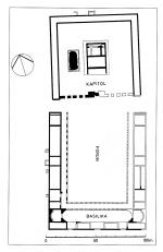
The Forum – more than one public plaza has nowhere yet been attested – lay, as far as is known, with its axes or two of its side borders at a junction of the decumanus maximus or cardo maximus, although not necessarily directly in the centre of the town. Only the fora of Teurnia and Virunum have been to some extent analysed, nevertheless almost 100 years ago. The Forum of Celeia has recently been located with the aid of modern small-scale investigations. In all cases, the Fora seem to have resembled open plazas accompanied on their long sides by colonnades with offices for public officials and shops, with a basilica located at one of the short sides. The second short side apparently remained undeveloped, in order to afford an unobstructed view of the adjoining area sacra with its main temple of the city.
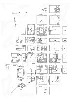
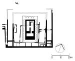
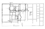
Excavations in around 1910 revealed such an area sacra in Virunum, enframed by a U-form colonnade with cryptoporticus and extending over an entire insula (almost 90 m. long per side) on an artificially elevated piazza (1.8 m. height) adjoining the Forum to the north. In the centre of this plaza stood a podium temple (35.6 x 24.6 m.) with a deep pronaos formed only by columns, and with a tripartite cella (proportions 1 : 2 : 1), which is indentified in the scholarship as a Capitolium. Almost directly to the west of this main temple an additional platform measuring 22.35 x 11.1 m. was uncovered; this was for a long time interpreted as a basis for a monument, but more recently it has been proposed that this formed the substructure of yet another temple.
At Celeia, sections of the Forum and of a sacred area adjoining it – in a similar fashion to that at Virunum – with a monumental temple building have recently been archaeologically investigated; the existence of the sacred area has been known since the 18th century. From the preserved substructure, it can be determined that the temple possessed a tripartite cella with proportions of 3 : 4 : 3 and a pronaos which was nearly as deep as the cella. The podium was apparently 100 Roman feet (29.6 m.) in width and probably 180 feet (53.3 m.) in length, while the temple itself could have been up to 47 m. long and ca. 28 m. wide. A column, discovered in this area already in the 19th century, has a diameter of 1.3 m. Based on the location and the dimensions, which accord with the statements of the Augustan-period architectural theorist, Vitruvius, the temple at Celeia has been assumed to be a Capitolium, as at Virunum. Furthermore, in close proximity to the temple at Celeia, a marble head and additional fragments of a statue, such as hands and knees, as well as part of the hip of a 5 m. tall colossal statue of Apollo were found already in ca. 1900. Such a statue is without parallel in Noricum. It can only have constituted the cult statue of a highly important temple, therefore of this temple. The identification of each of the main temples at Virunum and Celeia as a Capitolium was based entirely on the division of the preserved substructure into three parts, and on the location next to the Forum. The fact, however, that an Apollo head is preserved from Celeia as a cult statue or an element of a cult statuary group, combined with the fact that no inscriptions from Noricum attest to the presence of the Capitoline Triad, beyond such inscriptions from the provincial governorship in Lauriacum, this hypothetical assignment of the main temples to Jupiter, Juno and Minerva needs to be reconsidered. As far as can be dated, the Forum sites and the main temples at Virunum, Teurnia and Celeia, in their known form and decoration, were erected not before the early 2nd c., most likely in the Trajanic-Hadrianic period, therefore more than half a century after the formal city foundation.
 |
 |
 |
Virunum:
Forum and area sacra
|
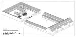
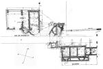
Virunum:
hypothetical reconstruction
of the Forum
|
Celeia:
part of the plan of the main
temple
|
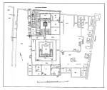
Additional temple buildings which are archaeologically well-documented from the cities of Noricum constitute exceptions. The oldest Roman temple in Noricum is the prostyle podium temple of the Corinthian order, erected during the reign of Emperor Tiberius (14-37 A.D.) on the north side of the Forum of the town on the Magdalensberg. The temple, which probably had two rooms (11.4 x 21.3 m.) stood on a 3 m. tall podium (13.5 x 27 m.) with steps integrated at the façade. Based on the substructures, the cella might have been divided into two, suggesting an identification as a cult structure for divus Augustus and dea Roma, a suggestion which however cannot be proved. A structure dating to the early Claudian period, with a pseudo-peripteral colonnade of 6 x 11 columns affixed to the walls, and with a surrounding colonnade (dimensions of the site: 54.6 x 45.3 m.) was never completed; its columns and entablature elements were probably removed to the new city of Virunum. For an additional temple area near the mountain summit, only such indications as dedicatory inscriptions and antefixes are preserved.
A further unidentified temple on the northern boundary of the city of Virunum is only comprehensible from its substructure. Even further out towards the edge of the city, in the angle at the junction of the main road running past Virunum (the tangential route) and that of the road branching off from it and leading to the so-called Capitolium and Forum, the decumanus maximus, is located an unenclosed area, recognised only from aerial photographs, extending roughly over 130 - 150 m., and with a single structure located almost in its centre. Based on the similarity of this area with one known from Cambodunum in Raetia, it has been interpreted as an ara Noricum, an assembly area for the Norican provincial government complete with Imperial altar. In addition, at Virunum a Dolichenum and at least two Mithraea, attested via inscriptions, are known. About 2.7 km. north of the Forum of Virunum, at the junction of the north-south road leading into the city and an east-west connecting road leading into the Glan valley, a temple precinct built at the vicus which grew up at this intersection has been investigated since 2001. On top of the remains of earlier buildings, which are not necessarily to be identified as having a cultic function, an irregularly formed, enclosed plaza, paved with paving stones and with a total area of 60 x 52 m., was laid out, most probably in the Hadrianic period. The surrounding colonnades in the east and west were fitted with two large exedrae located opposite each other, to which were adjoined taberna-form chambers open to the outside. The two-roomed podium temple (16.8 x 9.6 m.) oriented to the south, possessed an axially-located altar with socle dimensions of 3.6 x 2.7 m. Fragments of two votive altars, a votive column, and a bronze statue of the type of Hercules bibax (drunken Hercules) indicate that this temple was dedicated to Hercules.
On Miklavski hrb (Nikolausberg) on the edge of the city of Celeia, another temple area has been uncovered and conserved. A podium temple oriented to the east (19 x 8.50 m.), with cella and pronaos in approximate ratio of 2 : 1, was relatively tightly enclosed by colonnades on three sides. The southern colonnade had three exedrae, in one of which fragments of a life-size statue of Hercules were found; on the basis of this, the temple – probably incorrectly – received its name ‘Sanctuary of Hercules.’ Only a toe from the significantly larger cult statue has been found.
The only temples of gallo-roman type which have to date been discovered in the environs of any city in Noricum were first excavated in 2004 in Celeia and have not yet been published. They were erected in the 2nd c. A.D. inside a sacred area which already served a cultic function in the late Latène period. In Teurnia, no urban sanctuaries have yet been excavated, but the existence of a sacred precinct of Apollo Grannus is attested on the evidence of a building inscription found in the area around the Forum. Here, the temple is described as navale.
At Iuvavum, in addition to a sanctuary of Mercury known from inscriptions, only one temple structure probably erected in its final form during the Severan period is known archaeologically. Here were found the foundations of a peripteral temple, with exterior dimensions of 45.4 x 29.6 m. This cult building, so far unique in all of Noricum in terms of its form, was oriented east-west and possessed only one undivided inner room of ca. 32 x 16 m., according to the results of investigations so far. Based on finds of statuettes and a dedicatory inscription, the temple was dedicated to Asclepius; the only parallel for an Asclepius temple in the north-west provinces is at the site of Trier.
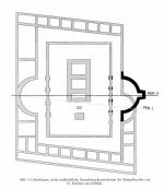
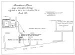
Within the urban framework of the remaining cities of Noricum, there are to date no secure finds relating to public temple precincts. Near Flavia Solva, however, an important sanctuary lay outside the urban area, on the high ground of the Frauenberg located within sight of the town. The mountain preserves intensive traces of a Bronze Age and Iron Age settlement; on one of its projecting spurs is a late Latène period sanctuary, only partially excavated, in the form of a circular ditch. Its period of use ended at the latest under Emperor Claudius, probably when the region became an official Roman province and when Celtic cult practices, connected with human sacrifice, were proscribed. As the successor to this site, a temple (exterior dimensions 23.5 x 13.5 m.) dedicated to Isis on the basis of fragments of the building inscription was erected on the highest point of the mountain, probably in the late Flavian period. The cella, which was roughly the same size as the pronaos, possessed a wide apse. In the entrance area, the excavations carried out between 1951– 1953 brought to light an altar for burnt offerings, which has however been called into question today. The exterior appearance of the temple probably took the form of an open row of columns in the area of the pronaos, with half-columns engaged to the cella wall. Neighbouring this temple to the south-west lay the walls of a slightly distorted square area with exterior dimensions of ca. 7.4 x 8.9, erected – according to the opinion of the excavators – in the Claudian-Neronian period. Surrounding this, a second square enclosure with exterior dimensions of ca. 24.3 x 22.7 was laid out in the Flavian period, whereby an originally free-standing single-roomed cult building was converted into a temple of gallo-roman type. After the late 1st century A.D., however, the cult activities were relocated to the neighbouring Isis temple. In late antiquity, the temple with surrounding colonnade was converted into a private residence.
 |
 |
Spatial
relationship between Solva and the temple precinct on the Frauenberg
|
Frauenberg near Solva: ground plan
of the Iseum
|
In conclusion, it can be stated that the podium temple, usually with a pronaos decorated with columns on three sides, constitutes the most common temple type in Noricum by far. In general, the temple stood in the middle of a precinct enclosed on three sides by colonnades.
It is hardly coincidental that the peripteral temple in Iuvavum was dedicated to the Greek god Asclepius. The temples with surrounding colonnades at Celeia are, to date, exceptions in an urban context and were built on top of a Latène period cultic area. The identification of the Grannus temple at Teurnia as a temple of gallo-roman type is also equally probable, due to its designation as navale (meaning uncertain), for which the only parallel is the Latobius temple in the Lavant valley in eastern Carinthia.
In practically every city in Noricum there is evidence for public and smaller private baths; it has only been possible, however, to investigate a few of these in large area. Most of these excavations were carried out at a relatively early date, and secure construction sequences as well as reliable ground plans can hardly be produced.
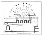
At the city on the Magdalensberg, already in the Augustan – Tiberian period a public bath with changing room and bathing room with apse was constructed within a larger building complex (the so-called Representation House), while a second one was located in the imperial lodging quarters (so-called Large Villa) near the goldsmithy. The decoration with wall paintings and black-and-white mosaics indicated the wealth of this trading city in Noricum, which at that time had only recently become a Roman possession.
 |
 |
Magdalensberg:
Bathing complex
|
Magdalensberg:
Lodging quarters of
the imperial goldsmithy
|
At Aguntum, the first building phase of a public bath complex of simple Row Type was first carried out in the Augustan period or shortly thereafter, on top of a demolished residential building. During a second building phase (late 1st century A.D.) the building was enlarged and functionally changed its axis by 90 degrees. In the course of the 2nd century, the baths were further enlarged and received additional small side rooms, after the room sequence of apodyterium (changing room) – frigidarium (cold baths) – tepidarium (lukewarm baths) – caldarium (warm baths).
At Celeia, the plan of a bathing complex conforming to the Block Type in the eastern sector of the town is only preserved in the form of a sketch made by the excavator in 1889. The decoration of the structure, in the form of frescoes on a red background and at least one black-and-white and one polychrome floor mosaic point to a Hadrianic date. A bath complex in the western sector of the city is equally to be dated to the 2nd century A.D.; this was partially excavated in the early 20th century, and two apsidal rooms with underfloor heating are known. The axes of these rooms are perpendicular to each other, and they were separated by a corridor.
 |
 |
Celeia:
Bathing complex in the east
of the city
|
Celeia,
Bathing complex in the west
of the city
|
The best-known private baths in Noricum are found in Virunum. These belonged to a larger building complex which took up all of Insula I neighbouring the Forum. The preserved decorative scheme with the well-known Dionysus mosaic and a re-used ensemble of marble statues of divinities must, however, first date to the 3rd century. For the less well-investigated insulae of Virunum which contained residential structures, similar private baths, nearly all with two apsidal rooms, are frequently encountered.
 |
 |
Virunum,
so-called Bathing District
|
Solva:
Insula V with peristyle houses
|
More of such private baths can also be identified in the peristyle houses in the centre of Solva (insulae V and IX). A probable public bathing complex, with a large recreation area nearby, was located in insula XXX. In insula XXII in the city’s core, an establishment with numerous rooms equipped with hypocaust heating, apses and mosaics has been seen as the main bathing complex for the city in the 3rd/4th centuries. Laid out from east to west and separated by corridors, the frigidarium, tepidarium and caldarium followed the heated apodyterium.
 |
 |
Solva:
Insula XXI with the public baths
|
Lauriacum:Baths of the Row Type
|
A simple bathing establishment belonging to the Row Type, with changing room and the series of three bathing rooms, has also been excavated in the so-called civilian town of Lauriacum.
In general, it can be stated that the Block- or Row Type of bathing establishment, with the sequence of bathing rooms for the three levels of heating laid out either in a ring or in a row, constitutes without exception the type of bath in the Norican towns. The significantly more expensive Imperial type, with its doubled units organised symmetrically, attached gymnasia and peristyle courtyards, designed to impress and taking up substantially more space, is not attested to date.
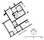
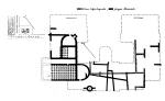
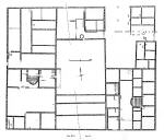
Examples of all of the known types of Roman houses are to be found in the Norican cities. The atrium-peristyle house at Aguntum, built in the mid-1st century A.D., constitutes a unique example for the northern provinces, with a total area of 3,000 m², courtyards, gardens, and probably also a bathing unit.
The main tract (ca. 61 x 30.5 m.) was oriented north-south, and possessed three large individual units: at the north, during building phase 1 (mid- to second-half of the 1st c. A.D.), a central rectangular atrium with impluvium was flanked at each side by three living rooms, each having an inner area of 50-70 m². In the 2nd c. A.D., an entrance room was separated off from the atrium and the western row of rooms was rebuilt for a different purpose: a heated passage now led past four markedly smaller rooms, the northernmost one now fitted with a hypocaust heating system. In the central section of the house, a roughly square garden peristyle covered the entire width of the house; this had a central water basin (15.5 x 17 m.) with watertight floor and walls of marble slabs. An additional row of rooms containing a triclinium constituted the southern termination. Connected to the east, and with approximately the same area as the imposing residential tract, additional heated rooms lay to the north, one of which had an apsis and which has until now been identified as a private bath.
Peristyle houses with 1,000 m² or more of built area are, however, also known from Virunum, Iuvavum and Flavia Solva. Nevertheless, their ground plans are either not completely apprehended, or the excavations took place before the Second World War, and the excavation methods and documentation left many questions of detail unanswered.
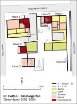
A significantly more modest form of house is represented by the type with a living tract closed off and set back from the street by courtyards for commercial use, and with an inner court open to the rear and surrounded by colonnades on three sides; such a house, dating to the 2nd/3rd c., is known from Cetium. This structure (Klostergarten, House 1) encompassed a total unwalled area of 28.4 x 12.2 m. To the north, at the street corner, were two open courtyards for commercial use, one of which was furnished with a cistern and a furnace. The living tract, with an area of 60 m² in the ground floor, divided into two large rooms and three small chambers, was relatively modest; an upper storey can however be assumed. The southern courtyard (total area 11.2 x 9.8 m.), which was surrounded on three sides by a 1.5 – 1.8 m. deep portico, was, by contrast, almost twice as large. An unwalled garden formed the southern limitation of the property.
 |
 |
 |
Cetium,
Klostergarten
|
Iuvavum:
Residential building with furnace
|
Iuvavum:
Residential Building with potter’s kiln
|
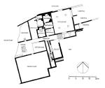
Similar houses on property of between 300 to 600 m², serving multiple functions as spaces for living, goods production, and commerce, and possessing one or more courtyards, small garden areas and a living tract of between three and five rooms (per storey) represent the majority of the houses in Noricum; particularly good examples of this type come from the latest excavations in Iuvavum.
The type of house with central corridor, particularly favoured in country areas and in some canabae settlements and limes towns, seems to have been less prevalent in the Norican cities. The structures in Flavia Solva which until now have been recognised as large residences of this type, are perhaps better explained as market buildings, hospitals, or industrial buildings.
At the edges of the city, the building density and the quality of decoration is generally reduced. Here, modest dwellings with at most three or four living rooms in a row, next to or behind each other, structurally separated commercial units with open sheds, and cellars either walled or provided with earth walls, are located in large court- and garden-areas, which fulfilled commercial purposes. A typical example is Insula XLI in Flavia Solva (2nd c. A.D.), or the construction on the residential terraces in Teurnia.
 |
 |
 |
Solva,
Insula LXI at the town border
|
Cetium,
western border
|
Teurnia,
esidential terraces
|
Particularly popular at the edges of the towns were houses related in type to the Row house, which had a single row of rooms standing within a piece of land. These generally had widths of 5.5 to 7 m., and lengths of 18 to 22 m. Numerous examples of this type are found in Cetium.
The urban periphery seems first to have been more densely developed in the Severan period, as new excavations in Virunum illustrate. Here, an area in the west of the city was extensively built up first in the late 2nd century, when the houses were provided with underfloor heating, bathing facilities, and in part even decoration with wall paintings.
Regarding construction techniques, it can be established that in all of the cities the foundation phase was dominated by wooden structures, mostly of half-timbered technique. Almost everywhere, this type of construction, or a mixed construction form, was freqently found at the limits of the town, but not exclusively throughout the entire Imperial period. Most of the houses in the peripheral districts, although also occasionally those closer to the town centre, appear to have had only a walled stone socle of 0.3 to 1.1 m. in height; above this, the construction technique was generally half-timbered. These more simple houses were only seldom decorated with wall paintings, but they almost always had stable concrete floors. In general, at least one upper storey can be assumed. Mosaics appear to have been laid down in any great extent first in the Severan period, and almost exclusively in houses which had peristyle courts. Underfloor heating systems constituted, in the 1st century and well into the 2nd century, rather the exception. If at all, only individual rooms were heated. Beginning first after the Severan period, more extensive heating systems came into use, and also at this time the number of private bathing establishments increased suddenly.
In conclusion, it can be observed that building construction in the private realm first achieved its full floruit in the years around 200 A.D., when the largest and most elaborate residences, and the most intensive construction activity, took place in the towns.
P. Scherrer
G. Alföldy, Noricum (1974).
H. Dolenz, Die Stadt auf dem Magdalensberg – das römische Zentrum Noricums, in: F. Humer (Hrsg.), Legionsadler und Druidenstab. Vom Legionslager zur Donaumetropole, Sonderausstellung aus Anlass des Jubiläums "2000 Jahre Carnuntum", Textband (Horn 2006) 122–129 (with extensive bibliography).
Th. Fischer, Noricum, Orbis Provinziarum (2002).
Th. Fischer, Beispiele zur Entstehung römischer Städte in den Nordwestprovinzen, in: Genese, Struktur und Entwicklung römischer Städte im 1. Jahrhundert n. Chr. in Nieder- und Obergermanien, hrsg. v. G. Precht, Xantener Berichte 9 (2001) 11–16.
V. Gassner – S. Jilek – S. Ladstätter, Am Rande des Reiches. Die Römer in Österreich, Österreichische Geschichte 15 v. Chr. – 378 n. Chr. (2002).
M. Harding – G. Jacobsen, Die Bedeutung der zivilen Zuwanderung aus Norditalien für die Entwicklung der Städte in Noricum und Pannonia, Classica et Mediaevalia 39, 1988, 117–206.
P. Jablonka, Die Siedlung auf der Gurina, Kärnten: Veneter – Kelten – Römer, in: Die Kelten in den Alpen und an der Donau. Akten des 1. Internat. Symp., St. Pölten, 14.–18. Okt. 1992, hrsg. von E. Jerem – A. Krenn-Leeb – J.-W. Neugebauer – O.H. Urban, Archaeolingua – Studien zur Eisenzeit im Ostalpenraum 1 (1996) 267–281.
G. Piccottini, Zu den augusteischen Ehreninschriften vom Magdalensberg, in: : "Eine ganz normale Inschrift" .... und ähnliches zum Geburtstag von Ekkehard Weber, hrsg. v. F. Beutler und W. Hameter, Althistorisch-Epigraphische Studien 5 (Wien 2005) 389–402.
G. Piccottini – H. Vetters, Führer durch die Ausgrabungen auf dem Magdalensberg6 (2002).
P. Scherrer, Vom regnum Noricum zur römischen Provinz: Grundlagen und Mechanismen der Urbanisierung, in: M. Šašel Kos — P. Scherrer (Hrsg.), The Autonomous Towns in Noricum and Pannonia – Die autonomen Städte in Noricum und Pannonien: Noricum, Situla 40 (2002) 11–70.
R. Wedenig, Epigraphische Quellen zur städtischen Administration in Noricum, Aus Forschung und Kunst 31 (1997).
For additional bibliographical references, see also the chapters on the individual towns, and the chapter on temples and cults in Noricum